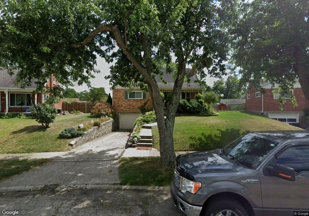
6934 Terrylynn Ln Cincinnati, OH 45239
Estimated Value: $213,000 - $234,000
4
Beds
2
Baths
1,785
Sq Ft
$127/Sq Ft
Est. Value
About This Home
This home is located at 6934 Terrylynn Ln, Cincinnati, OH 45239 and is currently estimated at $227,176, approximately $127 per square foot. 6934 Terrylynn Ln is a home located in Hamilton County with nearby schools including North College Hill Elementary School, North College Hill Middle School, and North College Hill High School.
Ownership History
Date
Name
Owned For
Owner Type
Purchase Details
Closed on
Mar 4, 1998
Sold by
Schmeisser Molly L
Bought by
Armstrong Fred W and Schmeisser Molly L
Current Estimated Value
Home Financials for this Owner
Home Financials are based on the most recent Mortgage that was taken out on this home.
Original Mortgage
$87,000
Interest Rate
7.15%
Create a Home Valuation Report for This Property
The Home Valuation Report is an in-depth analysis detailing your home's value as well as a comparison with similar homes in the area
Home Values in the Area
Average Home Value in this Area
Purchase History
| Date | Buyer | Sale Price | Title Company |
|---|---|---|---|
| Armstrong Fred W | -- | -- |
Source: Public Records
Mortgage History
| Date | Status | Borrower | Loan Amount |
|---|---|---|---|
| Closed | Armstrong Fred W | $87,000 |
Source: Public Records
Tax History
| Year | Tax Paid | Tax Assessment Tax Assessment Total Assessment is a certain percentage of the fair market value that is determined by local assessors to be the total taxable value of land and additions on the property. | Land | Improvement |
|---|---|---|---|---|
| 2025 | $2,878 | $61,601 | $8,894 | $52,707 |
| 2023 | $2,697 | $61,601 | $8,894 | $52,707 |
| 2022 | $2,972 | $41,979 | $7,497 | $34,482 |
| 2021 | $2,898 | $41,979 | $7,497 | $34,482 |
| 2020 | $2,939 | $41,979 | $7,497 | $34,482 |
| 2019 | $2,633 | $35,575 | $6,353 | $29,222 |
| 2018 | $2,634 | $35,575 | $6,353 | $29,222 |
| 2017 | $2,486 | $35,575 | $6,353 | $29,222 |
| 2016 | $2,356 | $33,534 | $6,265 | $27,269 |
| 2015 | $2,370 | $33,534 | $6,265 | $27,269 |
| 2014 | $2,369 | $33,534 | $6,265 | $27,269 |
| 2013 | $2,619 | $38,543 | $7,200 | $31,343 |
Source: Public Records
Map
Nearby Homes
- 2268 Deblin Dr
- 2391 Deblin Dr
- 2424 Banning Rd
- 2342 Banning Rd
- 2405 Amelia Ct
- 2427 Crosley Meadow
- 2031 Emerson Ave
- 2030 Emerson Ave
- 2125 Mckinley Ave
- 2027 Sundale Ave
- 7170 Longwood Ct
- 2048 4th Ave
- 2503 Flanigan Ct
- 1936 Cordova Ave
- 2757 Banning Rd
- 1938 Waltham Ave
- 1913 Sterling Ave
- 1944 Dallas Ave
- 6254 Betts Ave
- 2820 Geraldine Dr
- 6928 Terrylynn Ln
- 6940 Terrylynn Ln
- 6871 Kenbyrne Ct
- 6861 Kenbyrne Ct
- 6922 Terrylynn Ln
- 6881 Kenbyrne Ct
- 6851 Kenbyrne Ct
- 6948 Terrylynn Ln
- 6891 Kenbyrne Ct
- 2277 Deblin Dr
- 6929 Terrylynn Ln
- 6839 Kenbyrne Ct
- 2275 Deblin Dr
- 6916 Terrylynn Ln
- 6949 Terrylynn Ln
- 6827 Kenbyrne Ct
- 6921 Terrylynn Ln
- 6899 Kenbyrne Ct
- 2287 Deblin Dr
- 6815 Kenbyrne Ct
Your Personal Tour Guide
Ask me questions while you tour the home.