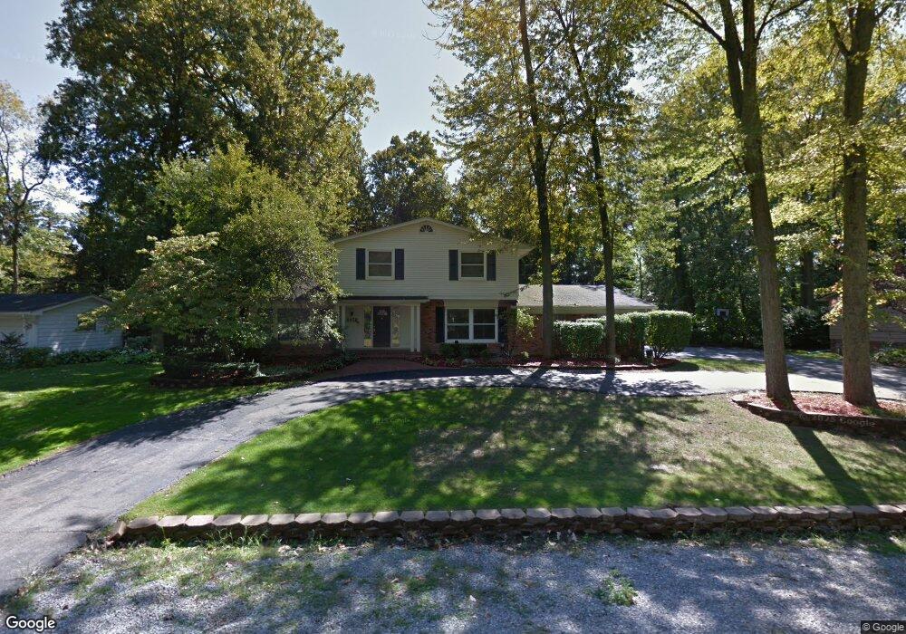
6938 Woodside Trail West Bloomfield, MI 48322
Estimated Value: $481,179 - $650,000
4
Beds
4
Baths
2,808
Sq Ft
$192/Sq Ft
Est. Value
About This Home
This home is located at 6938 Woodside Trail, West Bloomfield, MI 48322 and is currently estimated at $539,045, approximately $191 per square foot. 6938 Woodside Trail is a home located in Oakland County with nearby schools including Wylie E. Groves High School, West Maple Elementary School, and Berkshire Middle School.
Ownership History
Date
Name
Owned For
Owner Type
Purchase Details
Closed on
May 18, 2015
Sold by
Silverman David H and Feld Rochelle M
Bought by
Feld Rochelle M
Current Estimated Value
Purchase Details
Closed on
Dec 5, 2003
Sold by
Abel Bruce J and Abel Lori
Bought by
Silverman David H and Feld Rochelle M
Create a Home Valuation Report for This Property
The Home Valuation Report is an in-depth analysis detailing your home's value as well as a comparison with similar homes in the area
Home Values in the Area
Average Home Value in this Area
Purchase History
| Date | Buyer | Sale Price | Title Company |
|---|---|---|---|
| Feld Rochelle M | -- | None Available | |
| Silverman David H | $380,500 | First American Title |
Source: Public Records
Tax History Compared to Growth
Tax History
| Year | Tax Paid | Tax Assessment Tax Assessment Total Assessment is a certain percentage of the fair market value that is determined by local assessors to be the total taxable value of land and additions on the property. | Land | Improvement |
|---|---|---|---|---|
| 2024 | $2,498 | $213,290 | $0 | $0 |
| 2022 | $2,397 | $204,130 | $47,500 | $156,630 |
| 2021 | $3,975 | $175,230 | $0 | $0 |
| 2020 | $2,261 | $166,660 | $39,310 | $127,350 |
| 2018 | $3,917 | $161,150 | $27,300 | $133,850 |
| 2015 | -- | $108,720 | $0 | $0 |
| 2014 | -- | $101,460 | $0 | $0 |
| 2011 | -- | $87,560 | $0 | $0 |
Source: Public Records
Map
Nearby Homes
- 5312 Cambourne Place
- 7209 Stonebrook Rd
- 5241 S Pebblecreek Rd
- 6882 Post Oak Dr
- 6545 Post Oak Dr
- 7477 Gramercy Cir Unit 17
- 7479 Gramercy Cir Unit 16
- 6564 Alderley Way
- 7251 N Briarcliff Knoll Dr
- 7507 Gramercy Cir
- 7431 N Briarcliff Knoll Dr
- 7335 Coach Ln
- 2189 Colony Club Ct
- 32615 Briarcrest Knoll
- 32336 Tareyton St
- 30515 W 14 Mile Rd
- 2014 Waldons Ct
- 30475 W 14 Mile Rd Unit 80
- 32500 Rock Ridge Ln
- 7421 Heather Heath
- 6926 Woodside Trail
- 6950 Woodside Trail
- 6943 Woodside Trail
- 5252 N Pebblecreek Rd
- 5252 N Pebblecreek Rd
- 6925 Woodside Trail
- 6914 Woodside Trail
- 5240 N Pebblecreek Rd
- 5264 N Pebblecreek Rd
- 6962 Woodside Trail
- 6957 Woodside Trail
- 6911 Woodside Trail
- 5228 N Pebblecreek Rd
- 5276 N Pebblecreek Rd
- 6920 Candlewood Trail
- 6872 Woodside Trail
- 6936 Candlewood Trail
- 6850 Candlewood Trail
- 7043 Riverstone Rd
- 5216 N Pebblecreek Rd