Estimated Value: $79,096 - $233,000
4
Beds
1
Bath
1,192
Sq Ft
$108/Sq Ft
Est. Value
About This Home
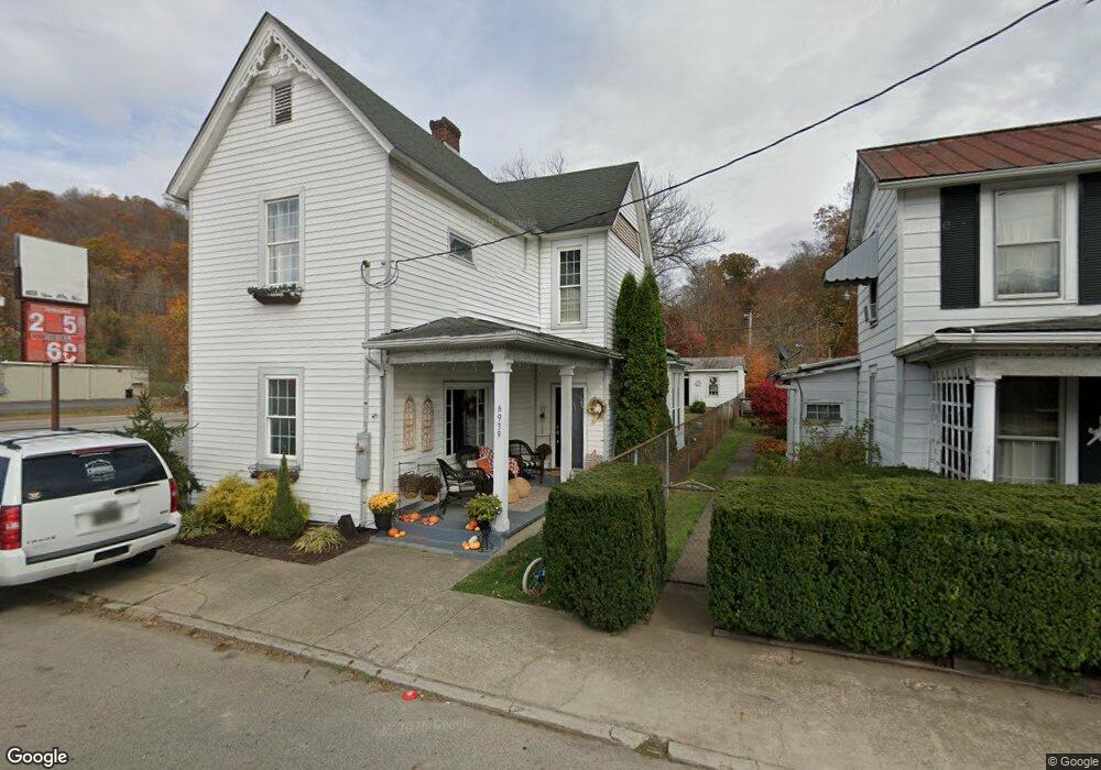
This home is located at 6939 State Route 73, Otway, OH 45657 and is currently estimated at $128,274, approximately $107 per square foot. 6939 State Route 73 is a home located in Scioto County with nearby schools including Northwest Elementary School, Northwest Middle School, and Northwest High School.
Ownership History
Date
Name
Owned For
Owner Type
Purchase Details
Closed on
Jul 27, 2004
Sold by
Enz Eugene
Bought by
Enz Eugene + Valerie J and Enz S
Current Estimated Value
Purchase Details
Closed on
May 23, 2004
Sold by
Eugene Eugene
Bought by
Enz Valerie
Purchase Details
Closed on
May 1, 2002
Sold by
Enz-Doss Valerie
Bought by
Enz Eugene
Purchase Details
Closed on
Apr 10, 2001
Sold by
Doss Valerie K + John
Bought by
Enz-Doss Valerie
Purchase Details
Closed on
Feb 26, 1999
Sold by
Mason Terri
Bought by
Doss Valerie K + John
Create a Home Valuation Report for This Property
The Home Valuation Report is an in-depth analysis detailing your home's value as well as a comparison with similar homes in the area
Home Values in the Area
Average Home Value in this Area
Purchase History
| Date | Buyer | Sale Price | Title Company |
|---|---|---|---|
| Enz Eugene + Valerie J | -- | -- | |
| Enz Valerie | -- | -- | |
| Enz Eugene | $40,000 | -- | |
| Enz-Doss Valerie | -- | -- | |
| Doss Valerie K + John | $25,000 | -- |
Source: Public Records
Tax History Compared to Growth
Tax History
| Year | Tax Paid | Tax Assessment Tax Assessment Total Assessment is a certain percentage of the fair market value that is determined by local assessors to be the total taxable value of land and additions on the property. | Land | Improvement |
|---|---|---|---|---|
| 2024 | $787 | $15,650 | $710 | $14,940 |
| 2023 | $787 | $15,650 | $710 | $14,940 |
| 2022 | $783 | $15,650 | $710 | $14,940 |
| 2021 | $628 | $12,500 | $610 | $11,890 |
| 2020 | $612 | $12,500 | $610 | $11,890 |
| 2019 | $536 | $12,500 | $610 | $11,890 |
| 2018 | $607 | $12,500 | $610 | $11,890 |
| 2017 | $607 | $12,500 | $610 | $11,890 |
| 2016 | $555 | $11,490 | $610 | $10,880 |
| 2015 | $555 | $11,490 | $610 | $10,880 |
| 2013 | $499 | $11,490 | $610 | $10,880 |
Source: Public Records
Map
Nearby Homes
- 613 Curtis Smith Rd
- Ohio 348
- 2840 Henley Comstock Rd
- 3566 Henley Comstock Rd
- 1956 Conley Rd
- 3887 Knoxel Hill-Bracken Ridge Rd
- 7085 Big Spruce Little Bear Ck
- 6581 Big Spruce-Little Bear Rd
- 0 Oppy Hill Rd
- 12259 Ohio 348
- Oppy Hill Rd Lot Unit Wp001
- 525 Martin Cemetery Rd
- 12808 Ohio 348
- 948 Big Bear Creek Rd
- 2800 Beech Fork Rd
- van Crabtree Cemetery Road Lot Unit Wp001
- 0 Bear Creek Rarden Rd
- 12705
- 0 van Crabtree Road Lot Unit Wp001
- 3111 Big Bear Creek Rd
- 6945 State Route 73
- 6989 State Route 73
- 6979 St Rt 73
- 31 31 Mt Hope
- 6480 State Route 348
- 9811 Ohio 348
- 6958 State Route 73
- 2263 Ohio 73
- 73 Sr
- 6942 State Route 73
- 6942 State Route 73
- 6993 State Route 73
- 6893 State Route 73
- 6995 State Route 73
- 81 Newman Alley
- 0 Newman Alley Unit 1311130
- 7007 State Route 73
- 7007 Ohio 73
- 6528 Ohio 348
- 6528 State Route 348