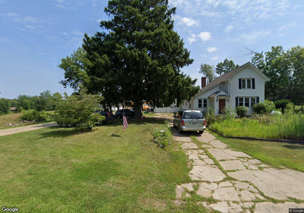
6945 Springport Rd Jackson, MI 49201
Estimated Value: $274,542 - $390,000
3
Beds
2
Baths
1,768
Sq Ft
$181/Sq Ft
Est. Value
About This Home
This home is located at 6945 Springport Rd, Jackson, MI 49201 and is currently estimated at $319,847, approximately $180 per square foot. 6945 Springport Rd is a home located in Jackson County with nearby schools including Northwest Early Elementary School, Northwest Elementary School, and Northwest Middle School.
Ownership History
Date
Name
Owned For
Owner Type
Purchase Details
Closed on
Apr 2, 2019
Sold by
Ranck Ronda R
Bought by
Ranck Dwight M
Current Estimated Value
Home Financials for this Owner
Home Financials are based on the most recent Mortgage that was taken out on this home.
Original Mortgage
$134,000
Outstanding Balance
$117,810
Interest Rate
4.3%
Mortgage Type
New Conventional
Estimated Equity
$202,037
Purchase Details
Closed on
Jan 1, 1994
Bought by
Ranck
Create a Home Valuation Report for This Property
The Home Valuation Report is an in-depth analysis detailing your home's value as well as a comparison with similar homes in the area
Purchase History
| Date | Buyer | Sale Price | Title Company |
|---|---|---|---|
| Ranck Dwight M | -- | None Available | |
| Ranck | -- | -- |
Source: Public Records
Mortgage History
| Date | Status | Borrower | Loan Amount |
|---|---|---|---|
| Open | Ranck Dwight M | $134,000 |
Source: Public Records
Tax History
| Year | Tax Paid | Tax Assessment Tax Assessment Total Assessment is a certain percentage of the fair market value that is determined by local assessors to be the total taxable value of land and additions on the property. | Land | Improvement |
|---|---|---|---|---|
| 2025 | $2,205 | $121,800 | $0 | $0 |
| 2024 | $11 | $101,800 | $0 | $0 |
| 2023 | $1,033 | $87,200 | $0 | $0 |
| 2022 | $2,000 | $80,500 | $0 | $0 |
| 2021 | $1,968 | $78,200 | $0 | $0 |
| 2020 | $1,951 | $75,600 | $0 | $0 |
| 2019 | $1,903 | $71,100 | $0 | $0 |
| 2018 | $1,881 | $70,100 | $0 | $0 |
| 2017 | $1,773 | $63,600 | $0 | $0 |
| 2016 | $1,694 | $64,688 | $64,688 | $0 |
| 2015 | $1,694 | $65,061 | $65,061 | $0 |
| 2014 | $1,694 | $68,834 | $0 | $0 |
| 2013 | -- | $68,834 | $68,834 | $0 |
Source: Public Records
Map
Nearby Homes
- 6631 Springport Rd
- 4350 Bailey Rd
- 5331 Stepladder Rd
- 6750 County Farm Rd
- 0 Carlson Rd
- 2770 N Dearing Rd
- 0 Michigan 50
- 3891 Wellman Rd
- 3990 Wellman Rd
- 4131 York Ln
- 8900 County Farm Rd
- 177 Old Wagon Trail
- 151 Old Wagon Trail
- 8706 Abbey Rd
- 2431 N Dearing Rd
- 4845 Firethorne Dr
- 4048 Knightsbridge Ln
- 3249 Hendee Rd
- 6067 Leora Ln
- 2001 N Harrington Rd
- 6946 Springport Rd
- 6900 Springport Rd
- 6946 Springport Rd
- 6946 Springport Rd
- 6920 Springport Rd
- 6920 Springport Rd
- 6745 Springport Rd
- 5990 N Sandstone Rd
- 5998 N Sandstone Rd
- 5955 N Sandstone Rd
- 7155 Springport Rd
- 7170 Springport Rd
- 6760 Springport Rd
- 6100 N Sandstone Rd
- 5995 N Sandstone Rd
- 6810 Springport Rd
- 6810 Springport Rd
- 6810 Springport Rd
- 7247 Springport Rd
- 6710 Springport Rd
Your Personal Tour Guide
Ask me questions while you tour the home.