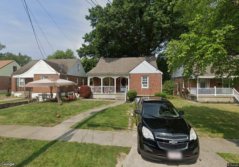
6947 Gloria Dr Cincinnati, OH 45239
Estimated Value: $221,000 - $247,000
4
Beds
2
Baths
2,081
Sq Ft
$112/Sq Ft
Est. Value
About This Home
This home is located at 6947 Gloria Dr, Cincinnati, OH 45239 and is currently estimated at $233,254, approximately $112 per square foot. 6947 Gloria Dr is a home located in Hamilton County with nearby schools including North College Hill Elementary School, North College Hill Middle School, and North College Hill High School.
Ownership History
Date
Name
Owned For
Owner Type
Purchase Details
Closed on
Jun 28, 2010
Sold by
Sprong Lawrence N and Sprong Julia A
Bought by
Adams Vie N
Current Estimated Value
Home Financials for this Owner
Home Financials are based on the most recent Mortgage that was taken out on this home.
Original Mortgage
$97,190
Outstanding Balance
$67,051
Interest Rate
5.5%
Mortgage Type
FHA
Estimated Equity
$166,203
Purchase Details
Closed on
Jul 3, 2004
Sold by
Sprong Julia A
Bought by
Sprong Lawrence N and Sprong Julia A
Create a Home Valuation Report for This Property
The Home Valuation Report is an in-depth analysis detailing your home's value as well as a comparison with similar homes in the area
Home Values in the Area
Average Home Value in this Area
Purchase History
| Date | Buyer | Sale Price | Title Company |
|---|---|---|---|
| Adams Vie N | $98,500 | Attorney | |
| Sprong Lawrence N | -- | -- |
Source: Public Records
Mortgage History
| Date | Status | Borrower | Loan Amount |
|---|---|---|---|
| Open | Adams Vie N | $97,190 |
Source: Public Records
Tax History Compared to Growth
Tax History
| Year | Tax Paid | Tax Assessment Tax Assessment Total Assessment is a certain percentage of the fair market value that is determined by local assessors to be the total taxable value of land and additions on the property. | Land | Improvement |
|---|---|---|---|---|
| 2024 | $2,684 | $53,047 | $6,080 | $46,967 |
| 2023 | $2,708 | $53,047 | $6,080 | $46,967 |
| 2022 | $2,137 | $29,880 | $4,977 | $24,903 |
| 2021 | $2,091 | $29,880 | $4,977 | $24,903 |
| 2020 | $1,835 | $29,880 | $4,977 | $24,903 |
| 2019 | $1,796 | $26,209 | $4,365 | $21,844 |
| 2018 | $1,796 | $26,209 | $4,365 | $21,844 |
| 2017 | $1,695 | $26,209 | $4,365 | $21,844 |
| 2016 | $1,980 | $32,407 | $6,304 | $26,103 |
| 2015 | $1,985 | $32,407 | $6,304 | $26,103 |
| 2014 | $1,983 | $32,407 | $6,304 | $26,103 |
| 2013 | $2,047 | $34,475 | $6,706 | $27,769 |
Source: Public Records
Map
Nearby Homes
- 6942 Gloria Dr
- 6943 Mulberry St
- 6941 Mulberry St
- 2943 Pin Oak Dr
- 1850 Bising Ave
- 1842 Bising Ave
- 1841 Bising Ave
- 8729 Morningstar Ln
- 8515 Pollux Ct
- 2033 Sundale Ave
- 2029 Sundale Ave
- 6842 Grace Ave
- 1917 Dallas Ave
- 2439 Pin Ct
- 1835 Dallas Ave
- 1818 Dallas Ave
- 2422 Bluelark Dr
- 8265 Haskell Dr
- 1623 Norcol Ln
- 2390 Golf Dr
- 6945 Gloria Dr
- 6949 Gloria Dr
- 6943 Gloria Dr
- 6951 Gloria Dr
- 6953 Gloria Dr
- 6941 Gloria Dr
- 6946 Mar Bev Dr
- 6944 Mar Bev Dr
- 6942 Mar Bev Dr
- 6948 Mar Bev Dr
- 6939 Gloria Dr
- 6950 Mar Bev Dr
- 6940 Mar Bev Dr
- 6948 Gloria Dr
- 6950 Gloria Dr
- 6946 Gloria Dr
- 6944 Gloria Dr
- 6952 Gloria Dr
- 6937 Gloria Dr
- 6954 Gloria Dr