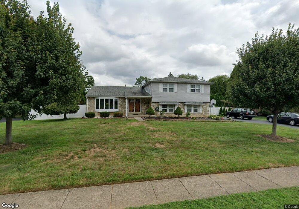
695 Killdeer Ln Huntingdon Valley, PA 19006
Lower Moreland NeighborhoodEstimated Value: $604,000 - $689,000
4
Beds
3
Baths
2,488
Sq Ft
$259/Sq Ft
Est. Value
About This Home
This home is located at 695 Killdeer Ln, Huntingdon Valley, PA 19006 and is currently estimated at $644,913, approximately $259 per square foot. 695 Killdeer Ln is a home located in Montgomery County with nearby schools including Pine Road Elementary School, Murray Avenue School, and Lower Moreland High School.
Ownership History
Date
Name
Owned For
Owner Type
Purchase Details
Closed on
Oct 18, 2012
Sold by
Abraham Thomas and Thomas Marykutty
Bought by
Abraham Thoma and Thomas Marykutty
Current Estimated Value
Home Financials for this Owner
Home Financials are based on the most recent Mortgage that was taken out on this home.
Original Mortgage
$171,000
Interest Rate
3.42%
Mortgage Type
New Conventional
Purchase Details
Closed on
Sep 30, 2003
Sold by
Lee Sang G and Lee Jung S
Bought by
Thomas Marykutty and Abraham Thomas
Home Financials for this Owner
Home Financials are based on the most recent Mortgage that was taken out on this home.
Original Mortgage
$272,000
Interest Rate
6.43%
Create a Home Valuation Report for This Property
The Home Valuation Report is an in-depth analysis detailing your home's value as well as a comparison with similar homes in the area
Home Values in the Area
Average Home Value in this Area
Purchase History
| Date | Buyer | Sale Price | Title Company |
|---|---|---|---|
| Abraham Thoma | -- | None Available | |
| Thomas Marykutty | $340,000 | -- |
Source: Public Records
Mortgage History
| Date | Status | Borrower | Loan Amount |
|---|---|---|---|
| Closed | Abraham Thoma | $171,000 | |
| Previous Owner | Thomas Marykutty | $272,000 |
Source: Public Records
Tax History Compared to Growth
Tax History
| Year | Tax Paid | Tax Assessment Tax Assessment Total Assessment is a certain percentage of the fair market value that is determined by local assessors to be the total taxable value of land and additions on the property. | Land | Improvement |
|---|---|---|---|---|
| 2025 | $9,864 | $195,380 | $61,070 | $134,310 |
| 2024 | $9,864 | $195,380 | $61,070 | $134,310 |
| 2023 | $9,427 | $195,380 | $61,070 | $134,310 |
| 2022 | $9,150 | $195,380 | $61,070 | $134,310 |
| 2021 | $8,963 | $195,380 | $61,070 | $134,310 |
| 2020 | $8,696 | $195,380 | $61,070 | $134,310 |
| 2019 | $8,566 | $195,380 | $61,070 | $134,310 |
| 2018 | $1,859 | $195,380 | $61,070 | $134,310 |
| 2017 | $8,079 | $195,380 | $61,070 | $134,310 |
| 2016 | $8,003 | $195,380 | $61,070 | $134,310 |
| 2015 | $7,519 | $195,380 | $61,070 | $134,310 |
| 2014 | $7,519 | $195,380 | $61,070 | $134,310 |
Source: Public Records
Map
Nearby Homes
- 1581 Heather Rd
- 215 Gravel Hill Rd
- 3990 Berton Rd
- 247 Gravel Hill Rd
- 3660 Spring Run Rd
- 408 County Line Rd
- 468 Long Ln
- 1035 Wright Dr
- 1745 Brandywine Dr
- 3750 Wheatsheaf Rd
- 3567 Oriole Dr
- 1782 Brandywine Dr
- 523 Jason Dr
- 985 Milkweed Ln
- 3574 Glen Way
- 1011 Milkweed Rd
- 543 Jason Dr
- 3450 Woodward Rd
- 1018 Corn Crib Dr
- 3617 Sipler Ln
- 683 Killdeer Ln
- 703 Killdeer Ln
- 696 Killdeer Ln
- 704 Killdeer Ln
- 684 Killdeer Ln
- 11 Cameron Rd
- 671 Killdeer Ln
- 717 Killdeer Ln
- 1467 County Line Rd
- 21 Cameron Rd
- 718 Killdeer Ln
- 12 Stephenson Way
- 672 Killdeer Ln
- 697 Bobwhite Ln
- 705 Bobwhite Ln
- 659 Killdeer Ln
- 731 Killdeer Ln
- 685 Bobwhite Ln
- 719 Bobwhite Ln
- 22 Stephenson Way Unit 11