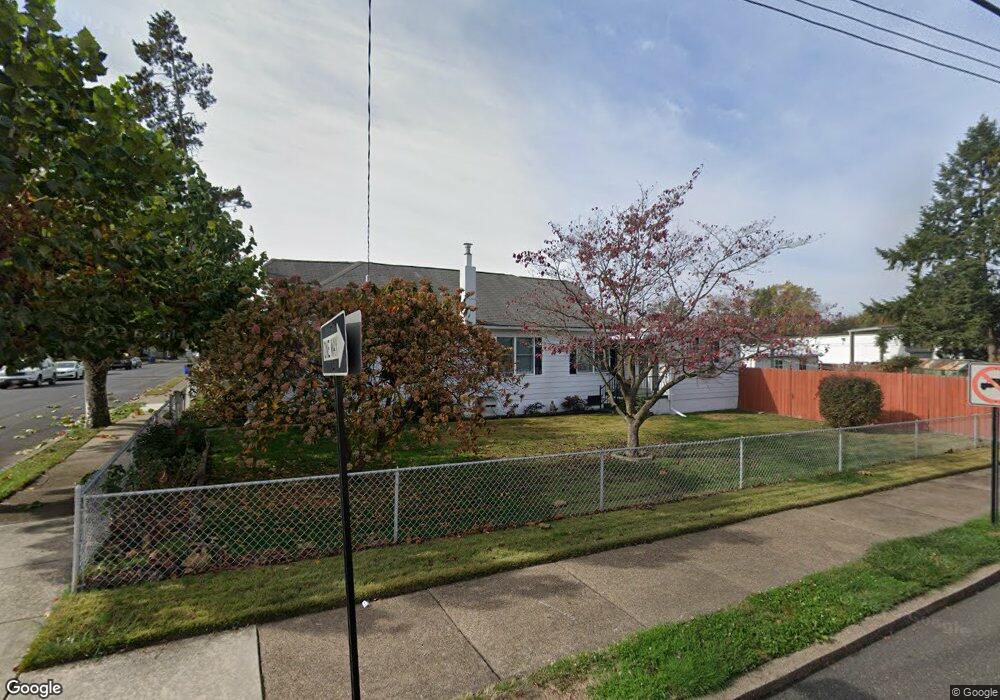
695 Spring St Bristol, PA 19007
Estimated Value: $261,115 - $370,000
--
Bed
2
Baths
1,546
Sq Ft
$206/Sq Ft
Est. Value
About This Home
This home is located at 695 Spring St, Bristol, PA 19007 and is currently estimated at $318,279, approximately $205 per square foot. 695 Spring St is a home located in Bucks County with nearby schools including Snyder-Girotti Elementary School, Bristol High School, and St. Mark Elementary School.
Ownership History
Date
Name
Owned For
Owner Type
Purchase Details
Closed on
Apr 5, 2021
Sold by
Warsheski Joseph E and Estate Of Joseph E Warsheski
Bought by
Warsheski Michael
Current Estimated Value
Purchase Details
Closed on
Mar 24, 2017
Sold by
Warsheski Louise and Warsheski Joseph E
Bought by
Warsheski Joseph E
Purchase Details
Closed on
May 30, 1986
Sold by
Warsheski Louise
Bought by
Warsheski Louise and Warsheski Joseph E
Create a Home Valuation Report for This Property
The Home Valuation Report is an in-depth analysis detailing your home's value as well as a comparison with similar homes in the area
Home Values in the Area
Average Home Value in this Area
Purchase History
| Date | Buyer | Sale Price | Title Company |
|---|---|---|---|
| Warsheski Michael | -- | Abramson Harvey | |
| Warsheski Joseph E | -- | None Available | |
| Warsheski Louise | -- | -- |
Source: Public Records
Tax History Compared to Growth
Tax History
| Year | Tax Paid | Tax Assessment Tax Assessment Total Assessment is a certain percentage of the fair market value that is determined by local assessors to be the total taxable value of land and additions on the property. | Land | Improvement |
|---|---|---|---|---|
| 2025 | $3,912 | $16,800 | $5,280 | $11,520 |
| 2024 | $3,912 | $16,800 | $5,280 | $11,520 |
| 2023 | $3,878 | $16,800 | $5,280 | $11,520 |
| 2022 | $3,878 | $16,800 | $5,280 | $11,520 |
| 2021 | $3,878 | $16,800 | $5,280 | $11,520 |
| 2020 | $3,987 | $16,800 | $5,280 | $11,520 |
| 2019 | $3,971 | $16,800 | $5,280 | $11,520 |
| 2018 | $3,971 | $16,800 | $5,280 | $11,520 |
| 2017 | $3,950 | $16,800 | $5,280 | $11,520 |
| 2016 | $3,950 | $16,800 | $5,280 | $11,520 |
| 2015 | -- | $16,800 | $5,280 | $11,520 |
| 2014 | -- | $16,800 | $5,280 | $11,520 |
Source: Public Records
Map
Nearby Homes
- 637 Spruce St
- 646 Spruce St
- 623 Spruce St
- 702 Fairview Ave
- 224 Buckley St
- 418 Jefferson Ave Unit 10
- 418 Jefferson Ave Unit 4
- 612 Pond St
- 446 Pond St
- 348 Jefferson Ave
- 114 Mifflin St
- 580 Bath St
- 4510 Fayette Dr
- 327 Wood St
- 900 Tower Rd
- 566 Swain St
- 216 Dorrance St
- 566 Linden St
- 209 Dorrance St
- 523 Swain St