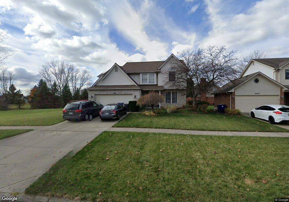
6951 Weatherfield Way Canton, MI 48187
Sunflower Village NeighborhoodEstimated Value: $530,000 - $552,000
--
Bed
3
Baths
2,569
Sq Ft
$213/Sq Ft
Est. Value
About This Home
This home is located at 6951 Weatherfield Way, Canton, MI 48187 and is currently estimated at $546,015, approximately $212 per square foot. 6951 Weatherfield Way is a home located in Wayne County with nearby schools including Canton High School, Plymouth High School, and Salem High School.
Ownership History
Date
Name
Owned For
Owner Type
Purchase Details
Closed on
Nov 18, 2021
Sold by
Edno Hiroyuki and Endo Heather C
Bought by
Edno Hiroyuki
Current Estimated Value
Home Financials for this Owner
Home Financials are based on the most recent Mortgage that was taken out on this home.
Original Mortgage
$296,000
Outstanding Balance
$271,608
Interest Rate
3.09%
Mortgage Type
New Conventional
Estimated Equity
$274,407
Purchase Details
Closed on
Jul 28, 1999
Sold by
Jozefowicz Debra M
Bought by
Endo Heather C
Create a Home Valuation Report for This Property
The Home Valuation Report is an in-depth analysis detailing your home's value as well as a comparison with similar homes in the area
Home Values in the Area
Average Home Value in this Area
Purchase History
| Date | Buyer | Sale Price | Title Company |
|---|---|---|---|
| Edno Hiroyuki | -- | Transtar National Title | |
| Endo Heather C | $292,000 | -- |
Source: Public Records
Mortgage History
| Date | Status | Borrower | Loan Amount |
|---|---|---|---|
| Open | Edno Hiroyuki | $296,000 |
Source: Public Records
Tax History Compared to Growth
Tax History
| Year | Tax Paid | Tax Assessment Tax Assessment Total Assessment is a certain percentage of the fair market value that is determined by local assessors to be the total taxable value of land and additions on the property. | Land | Improvement |
|---|---|---|---|---|
| 2025 | $3,237 | $274,200 | $0 | $0 |
| 2024 | $3,237 | $260,400 | $0 | $0 |
| 2023 | $3,086 | $247,900 | $0 | $0 |
| 2022 | $6,687 | $222,500 | $0 | $0 |
| 2021 | $6,490 | $211,100 | $0 | $0 |
| 2020 | $6,410 | $204,200 | $0 | $0 |
| 2019 | $6,292 | $196,100 | $0 | $0 |
| 2018 | $2,623 | $188,440 | $0 | $0 |
| 2017 | $6,355 | $183,600 | $0 | $0 |
| 2016 | $5,717 | $180,900 | $0 | $0 |
| 2015 | $14,412 | $165,690 | $0 | $0 |
| 2013 | $13,962 | $149,940 | $0 | $0 |
| 2010 | -- | $150,270 | $59,977 | $90,293 |
Source: Public Records
Map
Nearby Homes
- 7225 Camelia Ct
- 46500 E Oak Manor Ct
- 6844 Woodmere Dr
- 47691 Royal Pointe Dr
- 7040 Royal Villa Ct Unit 6
- 6596 Chadwick Dr
- 45900 Gainsborough Dr
- 6750 N Canton Center Rd
- 00000 Maben Rd
- 6680 Kings Mill Dr
- 47582 Fox Ct
- 50782 Ross St
- 48590 Ford Rd
- 48107 Hanford Rd
- 6894 Kings Mill Dr
- 8140 N Pointe Ct
- 45412 Embassy Ct
- 45812 Bartlett Dr
- 0 N Beck Rd
- 5872 Meadowview Dr
- 6969 Weatherfield Way
- 6950 Weathersfield Way
- 46291 Briargate Dr
- 46309 Briargate Dr
- 6950 Weatherfield Way
- 7005 Weatherfield Way
- 6932 Weatherfield Way
- 6968 Weatherfield Way
- 6914 Weatherfield Way
- 46292 Briargate Dr
- 46315 Briargate Dr
- 6986 Weatherfield Way
- 7023 Weatherfield Way
- 7004 Weathersfield Way
- 7004 Weatherfield Way
- 46310 Briargate Dr
- 46321 Briargate Dr
- 7041 Weatherfield Way
- 7022 Weatherfield Way
- 7056 Oakleaf Ct