Estimated Value: $300,313 - $476,000
3
Beds
2
Baths
1,486
Sq Ft
$236/Sq Ft
Est. Value
About This Home
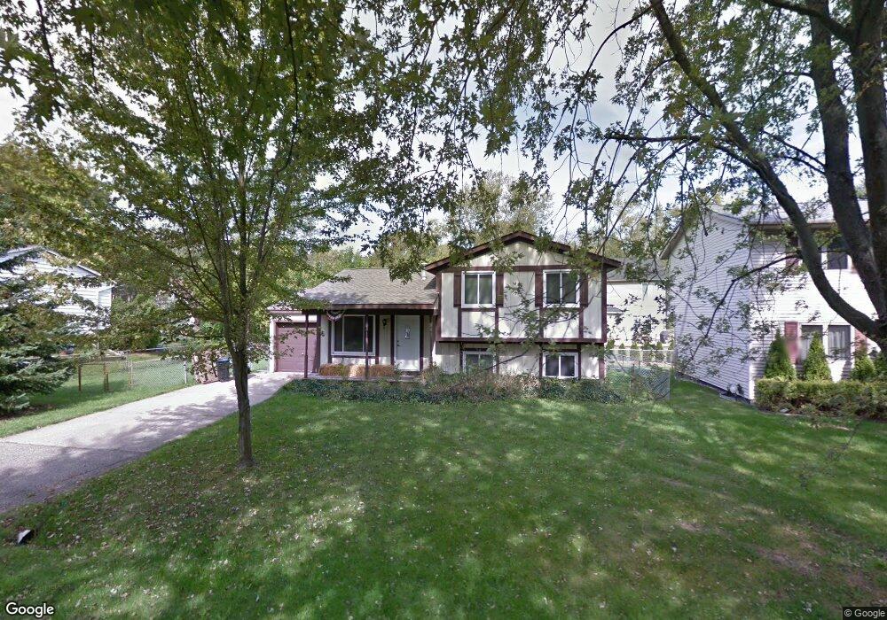
This home is located at 6960 Abbott, West Bloomfield, MI 48323 and is currently estimated at $350,078, approximately $235 per square foot. 6960 Abbott is a home located in Oakland County with nearby schools including Walled Lake Central High School, The Susan And Rabbi Harold Loss Ecc, and Brookfield Academy - West Bloomfield.
Ownership History
Date
Name
Owned For
Owner Type
Purchase Details
Closed on
Oct 1, 2024
Sold by
Oakland County
Bought by
Hp Foreclosure Solution Llc
Current Estimated Value
Purchase Details
Closed on
Dec 23, 1996
Sold by
Arthur Beschky Tr
Bought by
Musial Mitchell M
Home Financials for this Owner
Home Financials are based on the most recent Mortgage that was taken out on this home.
Original Mortgage
$13,100
Interest Rate
7.66%
Create a Home Valuation Report for This Property
The Home Valuation Report is an in-depth analysis detailing your home's value as well as a comparison with similar homes in the area
Home Values in the Area
Average Home Value in this Area
Purchase History
| Date | Buyer | Sale Price | Title Company |
|---|---|---|---|
| Hp Foreclosure Solution Llc | $170,098 | None Listed On Document | |
| Musial Mitchell M | $138,000 | -- |
Source: Public Records
Mortgage History
| Date | Status | Borrower | Loan Amount |
|---|---|---|---|
| Previous Owner | Musial Mitchell M | $13,100 |
Source: Public Records
Tax History
| Year | Tax Paid | Tax Assessment Tax Assessment Total Assessment is a certain percentage of the fair market value that is determined by local assessors to be the total taxable value of land and additions on the property. | Land | Improvement |
|---|---|---|---|---|
| 2025 | $4,276 | $132,460 | $36,070 | $96,390 |
| 2024 | $1,984 | $121,400 | $0 | $0 |
| 2022 | $1,871 | $113,900 | $36,070 | $77,830 |
| 2021 | $3,800 | $109,380 | $0 | $0 |
| 2020 | $1,802 | $104,910 | $36,070 | $68,840 |
| 2018 | $3,649 | $92,090 | $36,070 | $56,020 |
| 2015 | -- | $79,010 | $0 | $0 |
| 2014 | -- | $73,710 | $0 | $0 |
| 2011 | -- | $68,150 | $0 | $0 |
Source: Public Records
Map
Nearby Homes
- 4405 Green Lake Rd
- 4383 Green Lake Rd
- 4335 Crestdale Ave
- 6980 Hambro St
- 6978 Colony Dr
- 4212 Greendale Ave
- 3991 Fieldview Ave
- 3965 Carrick Ave
- 6790 Grassland Ave
- 3765 Woodview Ave
- 4765 Woodbine Cir
- 3666 Walnut
- 6885 Aeroview St
- 3575 Knollview Ave
- 7555 Windgate Cir
- 7369 Sweetbriar
- 7545/7585 Pontiac Trail
- 7585/7548 Pontiac Trail
- 6100 Pontiac Trail
- 6140 Pontiac Trail
- 6952 Abbott
- 6974 Abbott
- 6947 Manderson Terrace
- 6935 Manderson Terrace
- 6939 Abbott
- 6967 Abbott
- 6953 Manderson Terrace
- 6923 Manderson Terrace
- 6979 Abbott Trail
- 6979 Abbott
- 6982 Abbott
- 4416 Welland Dr
- 6930 Abbott
- 6907 Manderson Terrace
- 6934 Manderson Terrace
- 6952 Manderson Terrace
- 6969 Manderson Terrace
- 6993 Abbott
- 6900 Abbott
- 6920 Manderson Terrace
Your Personal Tour Guide
Ask me questions while you tour the home.