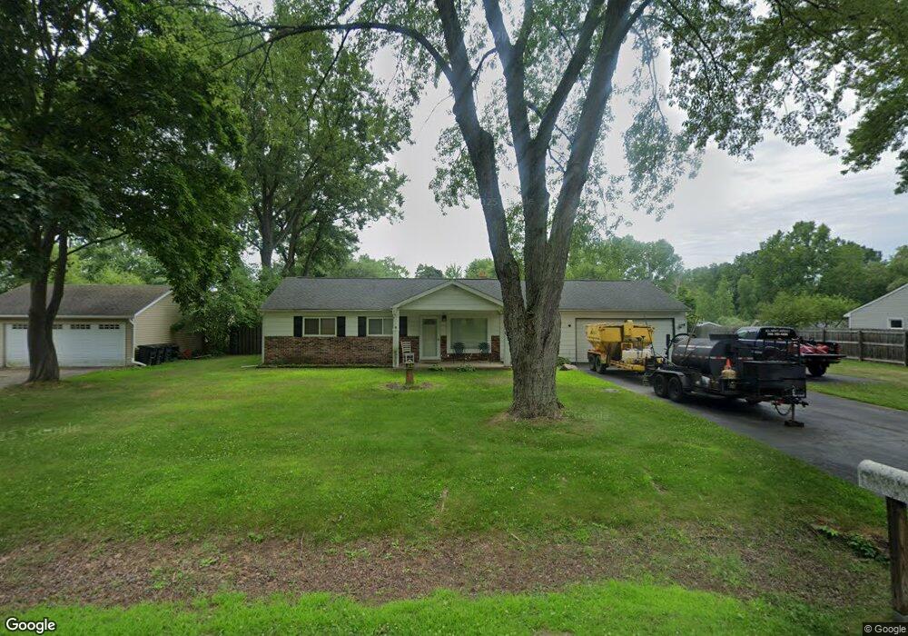
6961 Tappon Dr Clarkston, MI 48346
Estimated Value: $309,000 - $337,000
3
Beds
2
Baths
1,559
Sq Ft
$204/Sq Ft
Est. Value
About This Home
This home is located at 6961 Tappon Dr, Clarkston, MI 48346 and is currently estimated at $317,572, approximately $203 per square foot. 6961 Tappon Dr is a home located in Oakland County with nearby schools including Springfield Christian Academy, Our Lady Of The Lakes Catholic School, and Everest Academy.
Ownership History
Date
Name
Owned For
Owner Type
Purchase Details
Closed on
Nov 23, 2010
Sold by
Gaffney Saunders Jr Thomas F and Gaffney Saunders Janice
Bought by
Saunders Thomas F and Saunders Dustin Thomas
Current Estimated Value
Purchase Details
Closed on
Jul 7, 2005
Sold by
Davis Steven M and Davis Patricia M
Bought by
Saunders Thomas F
Purchase Details
Closed on
Nov 20, 2003
Sold by
Collier David M and Collier Mary Lorraine
Bought by
Davis Steven M and Davis Patricia M
Home Financials for this Owner
Home Financials are based on the most recent Mortgage that was taken out on this home.
Original Mortgage
$157,753
Interest Rate
6.1%
Mortgage Type
FHA
Create a Home Valuation Report for This Property
The Home Valuation Report is an in-depth analysis detailing your home's value as well as a comparison with similar homes in the area
Home Values in the Area
Average Home Value in this Area
Purchase History
| Date | Buyer | Sale Price | Title Company |
|---|---|---|---|
| Saunders Thomas F | -- | None Available | |
| Saunders Thomas F | $169,950 | Multiple | |
| Davis Steven M | $159,000 | Lawyers Title |
Source: Public Records
Mortgage History
| Date | Status | Borrower | Loan Amount |
|---|---|---|---|
| Previous Owner | Davis Steven M | $157,753 |
Source: Public Records
Tax History Compared to Growth
Tax History
| Year | Tax Paid | Tax Assessment Tax Assessment Total Assessment is a certain percentage of the fair market value that is determined by local assessors to be the total taxable value of land and additions on the property. | Land | Improvement |
|---|---|---|---|---|
| 2024 | $1,284 | $115,300 | $33,500 | $81,800 |
| 2023 | $1,731 | $102,700 | $28,100 | $74,600 |
| 2022 | $2,299 | $93,300 | $25,500 | $67,800 |
| 2021 | $2,300 | $88,800 | $23,200 | $65,600 |
| 2020 | $1,121 | $81,800 | $21,300 | $60,500 |
| 2018 | $2,185 | $75,100 | $15,000 | $60,100 |
| 2015 | -- | $51,200 | $0 | $0 |
| 2014 | -- | $47,000 | $0 | $0 |
| 2011 | -- | $62,500 | $0 | $0 |
Source: Public Records
Map
Nearby Homes
- 6832 Northcrest Way E Unit 31
- 7314 Village Park Dr Unit 47
- 5021 Paula Ave
- 6830 Dixie Hwy
- 9457 Dixie Hwy
- 7509 Maple Ridge Dr
- 4973 Parview Dr
- The Franklin II Plan at Park Ridge at Stonewood
- 7116 Oak Ridge Ct
- V/L Dixie Hwy
- 6940 Stonewood Place Dr
- 6920 Stonewood Place Unit 42
- 6944 Stonewood Place Unit 36
- 7541 Maple Ridge Dr
- 6788 Balmoral Terrace
- 7513 Maple Ridge Dr
- 6583 Ridgeview Dr
- 6535 Ridgeview Dr
- 6024 Overlook
- 5025 Timberway Trail