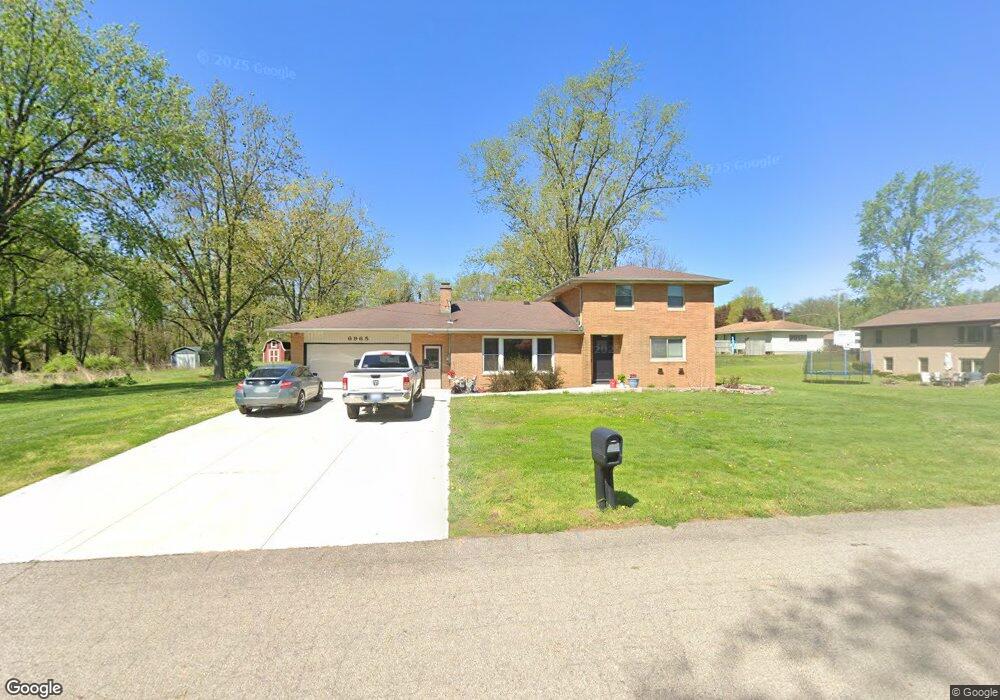
6965 Maple Ave Jenison, MI 49428
Estimated Value: $355,000 - $396,000
3
Beds
2
Baths
2,039
Sq Ft
$183/Sq Ft
Est. Value
About This Home
This home is located at 6965 Maple Ave, Jenison, MI 49428 and is currently estimated at $374,080, approximately $183 per square foot. 6965 Maple Ave is a home located in Ottawa County with nearby schools including Bursley School, Jenison Junior High School, and Jenison High School.
Ownership History
Date
Name
Owned For
Owner Type
Purchase Details
Closed on
Sep 11, 2019
Sold by
Busscher Gary L and Busscher Paul E
Bought by
Brown Rachel L and Brown Calvin
Current Estimated Value
Home Financials for this Owner
Home Financials are based on the most recent Mortgage that was taken out on this home.
Original Mortgage
$172,900
Outstanding Balance
$151,756
Interest Rate
3.7%
Mortgage Type
New Conventional
Estimated Equity
$222,324
Purchase Details
Closed on
Mar 1, 2016
Sold by
Busscher Johanna A and Busscher Arthur S
Bought by
Busscher Johanna A and Busscher Gary L
Create a Home Valuation Report for This Property
The Home Valuation Report is an in-depth analysis detailing your home's value as well as a comparison with similar homes in the area
Home Values in the Area
Average Home Value in this Area
Purchase History
| Date | Buyer | Sale Price | Title Company |
|---|---|---|---|
| Brown Rachel L | $182,000 | None Available | |
| Busscher Johanna A | -- | Attorney |
Source: Public Records
Mortgage History
| Date | Status | Borrower | Loan Amount |
|---|---|---|---|
| Open | Brown Rachel L | $172,900 |
Source: Public Records
Tax History
| Year | Tax Paid | Tax Assessment Tax Assessment Total Assessment is a certain percentage of the fair market value that is determined by local assessors to be the total taxable value of land and additions on the property. | Land | Improvement |
|---|---|---|---|---|
| 2025 | $2,579 | $181,300 | $0 | $0 |
| 2024 | $25 | $161,900 | $0 | $0 |
| 2023 | $2,367 | $155,600 | $0 | $0 |
| 2022 | $2,598 | $122,000 | $0 | $0 |
| 2021 | $2,523 | $112,900 | $0 | $0 |
| 2020 | $2,495 | $100,200 | $0 | $0 |
| 2019 | $2,139 | $92,200 | $0 | $0 |
| 2018 | $1,995 | $98,200 | $0 | $0 |
| 2017 | $1,960 | $97,000 | $0 | $0 |
| 2016 | $1,948 | $88,200 | $0 | $0 |
| 2015 | $1,859 | $78,400 | $0 | $0 |
| 2014 | $1,859 | $78,800 | $0 | $0 |
Source: Public Records
Map
Nearby Homes
- 7341 Pinegrove Dr
- 7373 Pinegrove Dr Unit 109
- 2111 Timberlane Dr
- 7439 Eastlane Ave
- 7425 Boulder Bluff Dr Unit 112
- 7425 Pinegrove Dr Unit 98
- 6352 Livingston Ct
- 7350 Glendora Ave
- 1634 Laramy Ln
- 9067 Hollace Ct
- 7391 Terrace Ln
- 2272 Baldwin St
- 1519 Eagle Shore Ct
- 6181 Gleneagle Highlands Dr
- 7522 Melody Ln
- 6325 8th Ave SW
- 1941 Newcastle Dr
- 6724 28th Ave
- 8148 Greenridge Dr
- 1468 Maplewood Dr Unit 9
- 6949 Maple Ave
- 1656 Rosewood St
- 1674 Rosewood St
- 1684 Rosewood St
- 6931 Maple Ave
- 6948 Maple Ave
- 1634 Rosewood St
- 1710 Rosewood St
- 6930 Maple Ave
- 1641 Rosewood St
- 1665 Rosewood St
- 1677 Rosewood St
- 6905 Maple Ave
- 1653 Rosewood St
- 1689 Rosewood St
- 1596 Rosewood St
- 1720 Rosewood St
- 6910 Maple Ave
- 7023 Eastwood Ave
- 1705 Rosewood St
Your Personal Tour Guide
Ask me questions while you tour the home.