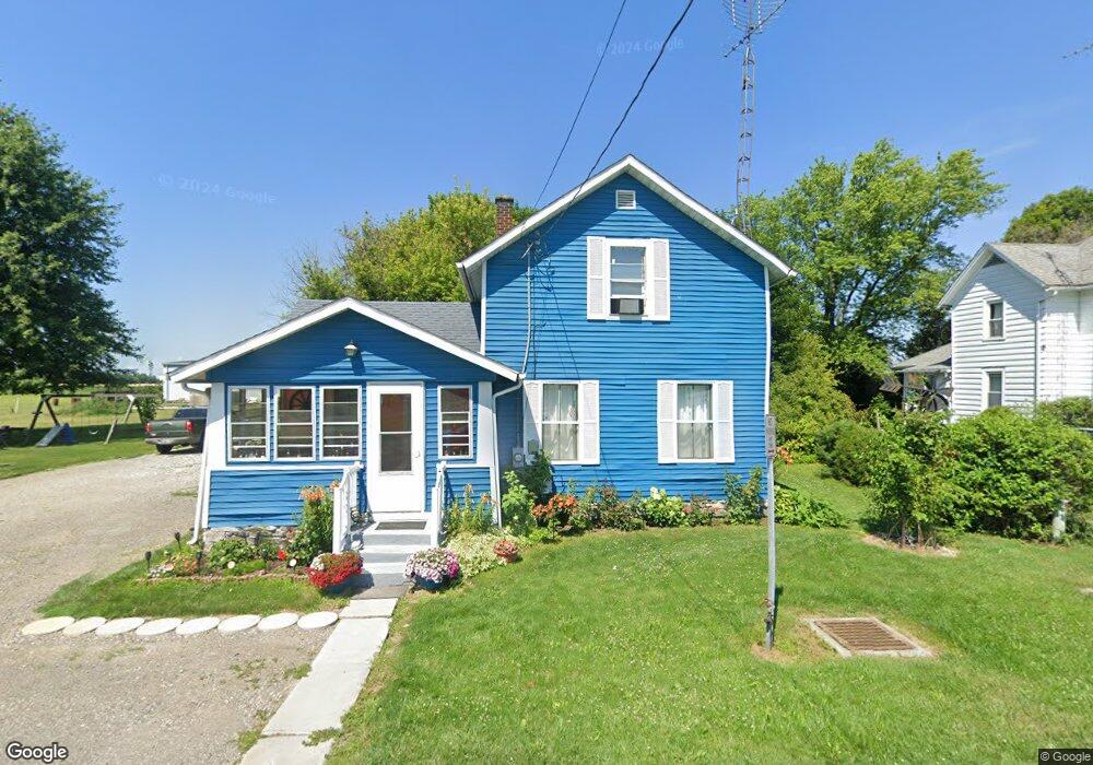
6965 State Route 66 Archbold, OH 43502
Estimated Value: $134,000 - $158,000
3
Beds
1
Bath
1,427
Sq Ft
$103/Sq Ft
Est. Value
About This Home
This home is located at 6965 State Route 66, Archbold, OH 43502 and is currently estimated at $147,452, approximately $103 per square foot. 6965 State Route 66 is a home located in Fulton County with nearby schools including Archbold Elementary School, Archbold Middle School, and Archbold High School.
Ownership History
Date
Name
Owned For
Owner Type
Purchase Details
Closed on
Nov 2, 2016
Sold by
The Secretary Of Housing & Urban Develop
Bought by
Zendejo Gonzalo Hernandez and Dehernandez Idalia Izaguirre
Current Estimated Value
Purchase Details
Closed on
Jan 13, 2015
Sold by
Wells Fargo Bank Na
Bought by
Secretary Of Housing & Urban Development
Purchase Details
Closed on
Dec 17, 2014
Sold by
Winchester Toni S
Bought by
Wells Fargo Bank Na
Purchase Details
Closed on
Nov 30, 2005
Sold by
Cline Jerry L and Cline Beatriz C
Bought by
Winchester Melvon and Winchester Toni
Purchase Details
Closed on
Jan 1, 1990
Bought by
Cline Jerry L and Cline Beatriz
Create a Home Valuation Report for This Property
The Home Valuation Report is an in-depth analysis detailing your home's value as well as a comparison with similar homes in the area
Purchase History
| Date | Buyer | Sale Price | Title Company |
|---|---|---|---|
| Zendejo Gonzalo Hernandez | $28,400 | Attorney | |
| Secretary Of Housing & Urban Development | -- | Old Republic | |
| Wells Fargo Bank Na | $43,333 | None Available | |
| Winchester Melvon | $58,000 | -- | |
| Cline Jerry L | -- | -- |
Source: Public Records
Tax History
| Year | Tax Paid | Tax Assessment Tax Assessment Total Assessment is a certain percentage of the fair market value that is determined by local assessors to be the total taxable value of land and additions on the property. | Land | Improvement |
|---|---|---|---|---|
| 2024 | $2,752 | $30,660 | $4,550 | $26,110 |
| 2023 | $2,707 | $30,660 | $4,550 | $26,110 |
| 2022 | $2,299 | $23,870 | $3,780 | $20,090 |
| 2021 | $2,451 | $23,870 | $3,780 | $20,090 |
| 2020 | $2,020 | $23,870 | $3,780 | $20,090 |
| 2019 | $2,073 | $20,550 | $3,780 | $16,770 |
| 2018 | $1,780 | $20,550 | $3,780 | $16,770 |
| 2017 | $1,815 | $20,550 | $3,780 | $16,770 |
| 2016 | $1,466 | $17,710 | $3,780 | $13,930 |
| 2015 | $1,576 | $17,710 | $3,780 | $13,930 |
| 2014 | $1,319 | $17,710 | $3,780 | $13,930 |
| 2013 | $1,610 | $20,270 | $3,500 | $16,770 |
Source: Public Records
Map
Nearby Homes
- 433 Primrose Ln
- 23161 County Road Jk
- 301 N Pointe Dr
- 408 Ditto St
- 800 Walnut St
- 208 Vine St
- 0 Lafayette St
- 808 West St
- 18857 U S 20a
- 226 Burke St
- 202 Short-Buehrer Rd
- 22227 Us Highway 20a
- 4427 County Road 19
- 224 Hawthorn Dr
- 285 Cherry St
- 902 E Church St
- 21530 County Road A
- Lot 35 of Rehn Dr
- 35 Rehn Dr
- 17830 County Road C
- 6977 State Route 66
- 6951 State Route 66
- 6956 State Route 66
- 6956 Ohio 66
- 23061 Us Highway 20a
- 22989 Monroe St
- 22959 Us Highway 20a
- 6904 State Route 66
- 6904 Ohio 66
- 22951 Monroe St
- 6886 State Route 66
- 22783 Monroe St
- 22923 Us Highway 20a
- 22923 U S 20a
- 23117 Us Highway 20a
- 22923 Monroe St
- 22895 Monroe St
- 7051 County Road 23
- 6878 Washington St
- 7109 County Road 23
Your Personal Tour Guide
Ask me questions while you tour the home.