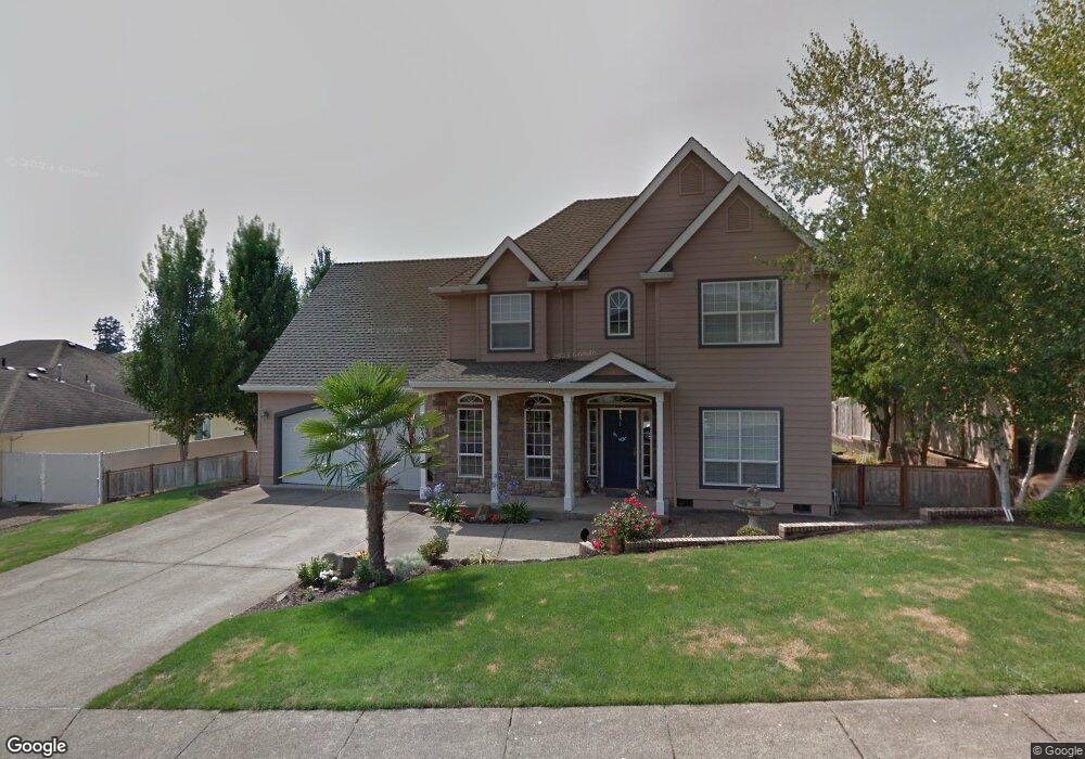
697 NW Allen Ct McMinnville, OR 97128
Estimated Value: $629,000 - $705,000
5
Beds
3
Baths
2,265
Sq Ft
$293/Sq Ft
Est. Value
About This Home
This home is located at 697 NW Allen Ct, McMinnville, OR 97128 and is currently estimated at $662,596, approximately $292 per square foot. 697 NW Allen Ct is a home located in Yamhill County with nearby schools including Newby Elementary School, Duniway Middle School, and McMinnville High School.
Ownership History
Date
Name
Owned For
Owner Type
Purchase Details
Closed on
Oct 15, 2007
Sold by
Sandlin Ernest H and Sandlin Jean E
Bought by
Schoof Aaron T and Schoof Trevalee
Current Estimated Value
Home Financials for this Owner
Home Financials are based on the most recent Mortgage that was taken out on this home.
Original Mortgage
$266,800
Outstanding Balance
$168,388
Interest Rate
6.42%
Mortgage Type
Purchase Money Mortgage
Estimated Equity
$494,208
Create a Home Valuation Report for This Property
The Home Valuation Report is an in-depth analysis detailing your home's value as well as a comparison with similar homes in the area
Home Values in the Area
Average Home Value in this Area
Purchase History
| Date | Buyer | Sale Price | Title Company |
|---|---|---|---|
| Schoof Aaron T | $333,500 | Ticor Title Insurance Co |
Source: Public Records
Mortgage History
| Date | Status | Borrower | Loan Amount |
|---|---|---|---|
| Open | Schoof Aaron T | $266,800 |
Source: Public Records
Tax History Compared to Growth
Tax History
| Year | Tax Paid | Tax Assessment Tax Assessment Total Assessment is a certain percentage of the fair market value that is determined by local assessors to be the total taxable value of land and additions on the property. | Land | Improvement |
|---|---|---|---|---|
| 2024 | $6,816 | $392,158 | -- | -- |
| 2023 | $6,435 | $380,736 | $0 | $0 |
| 2022 | $6,096 | $369,647 | $0 | $0 |
| 2021 | $5,952 | $358,881 | $0 | $0 |
| 2020 | $5,905 | $348,428 | $0 | $0 |
| 2019 | $5,745 | $338,280 | $0 | $0 |
| 2018 | $5,631 | $328,427 | $0 | $0 |
| 2017 | $5,435 | $318,861 | $0 | $0 |
| 2016 | $5,240 | $309,574 | $0 | $0 |
| 2015 | $5,113 | $300,559 | $0 | $0 |
| 2014 | $4,837 | $291,806 | $0 | $0 |
Source: Public Records
Map
Nearby Homes
- 2598 NW Meadows Dr
- 525 NW Hillcrest Loop
- 130 SW West Hills Dr
- 2317 SW Peggy St
- 197 SW Howard Dr
- 1924 NW Wallace Rd
- 2683 NW Mt Hood Dr
- 280 NW Country Ct
- 11790 SW Fox Ridge Rd
- 2650 NW Mt Ashland Dr
- 1276 NW Meadows Dr
- 361 SW Howard Dr
- 295 SW Mount Saint Helens St
- 2036 NW Woodland Dr
- 348 SW Mt Rainier St
- 459 SW Howard Dr
- 1795 NW Wallace Rd
- 177 SW Mt Mazama St
- 2805 NW Mount Ashland Ln
- 398 SW Mt Mazama St
- 671 NW Allen Ct
- 721 NW Allen Ct
- 700 NW Wintergreen Dr
- 678 NW Wintergreen Dr
- 684 NW Allen Ct
- 724 NW Wintergreen Dr
- 649 NW Allen Ct
- 753 NW Allen Ct
- 642 NW Wintergreen Dr
- 766 NW Allen Ct
- 762 NW Wintergreen Dr
- 2255 NW Horizon Dr
- 2225 NW Horizon Dr
- 2269 NW Horizon Dr
- 2287 NW Horizon Dr
- 2312 NW Wintergreen Ct
- 836 NW Wintergreen Dr
- 2309 NW Wintergreen Ct
- 812 NW Wintergreen Dr
- 747 NW Wintergreen Dr