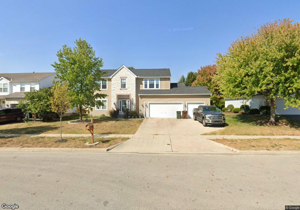
6975 Pearce Ln Canal Winchester, OH 43110
Estimated Value: $411,116 - $428,000
4
Beds
3
Baths
2,178
Sq Ft
$192/Sq Ft
Est. Value
About This Home
This home is located at 6975 Pearce Ln, Canal Winchester, OH 43110 and is currently estimated at $417,779, approximately $191 per square foot. 6975 Pearce Ln is a home located in Franklin County with nearby schools including Winchester Trail Elementary School, Indian Trail Elementary School, and Canal Winchester Middle School.
Ownership History
Date
Name
Owned For
Owner Type
Purchase Details
Closed on
Apr 27, 2011
Sold by
Fannie Mae
Bought by
Dunlevy Michael
Current Estimated Value
Home Financials for this Owner
Home Financials are based on the most recent Mortgage that was taken out on this home.
Original Mortgage
$143,273
Outstanding Balance
$99,062
Interest Rate
4.77%
Mortgage Type
FHA
Estimated Equity
$318,717
Purchase Details
Closed on
Jan 20, 2011
Sold by
Rossette Jennifer A and Rossette Michael J
Bought by
Federal National Mortgage Association
Purchase Details
Closed on
Mar 2, 2007
Sold by
W B Real Estate Vii Ltd
Bought by
Rossette Michael J and Rossette Jennifer A
Home Financials for this Owner
Home Financials are based on the most recent Mortgage that was taken out on this home.
Original Mortgage
$214,500
Interest Rate
6.27%
Mortgage Type
Purchase Money Mortgage
Purchase Details
Closed on
Jul 21, 2004
Sold by
Eastside Properties Partnership
Bought by
W B Real Estate Vii Ltd
Create a Home Valuation Report for This Property
The Home Valuation Report is an in-depth analysis detailing your home's value as well as a comparison with similar homes in the area
Home Values in the Area
Average Home Value in this Area
Purchase History
| Date | Buyer | Sale Price | Title Company |
|---|---|---|---|
| Dunlevy Michael | $147,000 | Nova Title | |
| Federal National Mortgage Association | $136,000 | None Available | |
| Rossette Michael J | $214,500 | Attorney | |
| W B Real Estate Vii Ltd | $35,000 | Stewart Tit |
Source: Public Records
Mortgage History
| Date | Status | Borrower | Loan Amount |
|---|---|---|---|
| Open | Dunlevy Michael | $143,273 | |
| Previous Owner | Rossette Michael J | $214,500 |
Source: Public Records
Tax History Compared to Growth
Tax History
| Year | Tax Paid | Tax Assessment Tax Assessment Total Assessment is a certain percentage of the fair market value that is determined by local assessors to be the total taxable value of land and additions on the property. | Land | Improvement |
|---|---|---|---|---|
| 2024 | $6,616 | $118,690 | $34,510 | $84,180 |
| 2023 | $6,578 | $118,685 | $34,510 | $84,175 |
| 2022 | $5,441 | $82,780 | $11,800 | $70,980 |
| 2021 | $5,498 | $82,780 | $11,800 | $70,980 |
| 2020 | $5,485 | $82,780 | $11,800 | $70,980 |
| 2019 | $5,444 | $70,150 | $9,840 | $60,310 |
| 2018 | $5,069 | $70,150 | $9,840 | $60,310 |
| 2017 | $5,069 | $70,150 | $9,840 | $60,310 |
| 2016 | $4,793 | $58,240 | $9,100 | $49,140 |
| 2015 | $4,806 | $58,240 | $9,100 | $49,140 |
| 2014 | $4,498 | $58,240 | $9,100 | $49,140 |
| 2013 | $2,340 | $61,320 | $9,590 | $51,730 |
Source: Public Records
Map
Nearby Homes
- 6430 Rossmore Ln
- 6469 Tallman Ct
- 6185 Dietz Dr
- 6571 Hemmingford Dr
- 6558 Hemmingford Dr
- 6535 Hemmingford Dr
- 7191 Rosemount Way
- 7250 Old Creek Ln
- 6216 Meriden Ct
- 0 Groveport Rd
- 7362 Bromfield Dr
- 7265 Bromfield Dr
- 7288 Bromfield Dr
- 525 Gender Rd
- 7412 Connor Ct
- 963 Groveport Rd
- 180 Woodsview Dr
- 6910 Canal St
- 185 Groveport Pike Unit 11A
- 185 Groveport Pike Unit 14D
- 6979 Pearce Ln
- 6969 Pearce Ln
- 6401 Rossmore Ln
- 6409 Rossmore Ln
- 6391 Rossmore Ln
- 6965 Pearce Ln
- 6978 Pearce Ln
- 7002 Abercorn Place
- 6383 Rossmore Ln
- 6423 Rossmore Ln
- 6982 Pearce Ln
- 6987 Pearce Ln
- 7003 Bromont Place
- 6373 Rossmore Ln
- 7012 Abercorn Place
- 7002 Pearce Ln
- 6991 Pearce Ln
- 7011 Abercorn Place
- 6406 Rossmore Ln
- 7015 Bromont Place