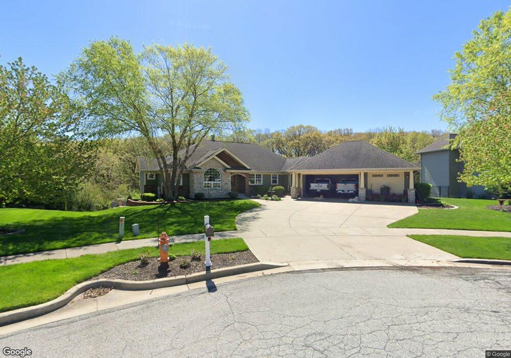
699 Pennock Cir Crown Point, IN 46307
Estimated Value: $562,000 - $793,000
4
Beds
3
Baths
2,380
Sq Ft
$296/Sq Ft
Est. Value
About This Home
This home is located at 699 Pennock Cir, Crown Point, IN 46307 and is currently estimated at $704,399, approximately $295 per square foot. 699 Pennock Cir is a home located in Lake County with nearby schools including Lake Street Elementary School, Robert Taft Middle School, and Crown Point High School.
Ownership History
Date
Name
Owned For
Owner Type
Purchase Details
Closed on
Sep 9, 2011
Sold by
Vandernoord Douglas R and Vandernoord Kristin
Bought by
Hlebasko Gregory A and Hlebasko Tracie M
Current Estimated Value
Home Financials for this Owner
Home Financials are based on the most recent Mortgage that was taken out on this home.
Original Mortgage
$414,100
Outstanding Balance
$282,689
Interest Rate
4.5%
Mortgage Type
FHA
Estimated Equity
$421,710
Create a Home Valuation Report for This Property
The Home Valuation Report is an in-depth analysis detailing your home's value as well as a comparison with similar homes in the area
Home Values in the Area
Average Home Value in this Area
Purchase History
| Date | Buyer | Sale Price | Title Company |
|---|---|---|---|
| Hlebasko Gregory A | -- | Fidelity Scher |
Source: Public Records
Mortgage History
| Date | Status | Borrower | Loan Amount |
|---|---|---|---|
| Open | Hlebasko Gregory A | $414,100 |
Source: Public Records
Tax History
| Year | Tax Paid | Tax Assessment Tax Assessment Total Assessment is a certain percentage of the fair market value that is determined by local assessors to be the total taxable value of land and additions on the property. | Land | Improvement |
|---|---|---|---|---|
| 2025 | $7,636 | $683,100 | $121,900 | $561,200 |
| 2024 | $16,779 | $668,500 | $121,900 | $546,600 |
| 2023 | $7,591 | $610,500 | $104,500 | $506,000 |
| 2022 | $7,340 | $582,200 | $104,500 | $477,700 |
| 2021 | $5,337 | $475,600 | $81,300 | $394,300 |
| 2020 | $5,266 | $469,300 | $81,300 | $388,000 |
| 2019 | $5,361 | $473,700 | $81,300 | $392,400 |
| 2018 | $7,141 | $478,000 | $81,300 | $396,700 |
| 2017 | $6,479 | $433,600 | $81,300 | $352,300 |
| 2016 | $6,458 | $427,700 | $81,300 | $346,400 |
| 2014 | $5,546 | $393,000 | $81,300 | $311,700 |
| 2013 | $5,387 | $379,200 | $81,300 | $297,900 |
Source: Public Records
Map
Nearby Homes
- 817 Mary Ellen Dr
- 804 Shannon Dr
- 815 Hayfield Dr
- 964 Ryan Ct
- 802 Hayfield Dr
- 914 Lillian Russell Ct
- 3709 W 121st Ave
- 437 Fairview Ave
- 460 O'Hagan Dr
- 1089 George Ade Ct
- 780 Williams Ct
- 217 Crestview Ln
- 745 Huey Dr
- 629 W South St
- 1140 Hyde Park
- 1002 Gordon Ct
- 123 Elmwood Place
- 109 Elmwood Place
- 3516 W 123rd Place
- 903 S Main St
Your Personal Tour Guide
Ask me questions while you tour the home.