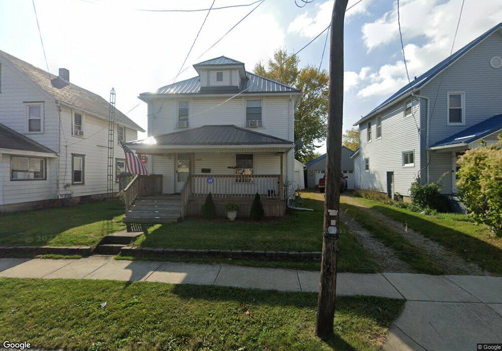
699 Woodrow Ave Marion, OH 43302
Estimated Value: $119,928 - $156,000
3
Beds
1
Bath
1,248
Sq Ft
$110/Sq Ft
Est. Value
About This Home
This home is located at 699 Woodrow Ave, Marion, OH 43302 and is currently estimated at $136,982, approximately $109 per square foot. 699 Woodrow Ave is a home located in Marion County with nearby schools including William McKinley Elementary School, Ulysses S. Grant Middle School, and Harding High School.
Ownership History
Date
Name
Owned For
Owner Type
Purchase Details
Closed on
Jan 8, 2007
Sold by
Maynard Michael
Bought by
Pennington Sheryl L and Pennington Michael D
Current Estimated Value
Home Financials for this Owner
Home Financials are based on the most recent Mortgage that was taken out on this home.
Original Mortgage
$67,500
Outstanding Balance
$46,591
Interest Rate
9.2%
Mortgage Type
Assumption
Estimated Equity
$90,391
Purchase Details
Closed on
Feb 3, 2003
Bought by
Pennington Sheryl L and Pennington Michael D
Create a Home Valuation Report for This Property
The Home Valuation Report is an in-depth analysis detailing your home's value as well as a comparison with similar homes in the area
Home Values in the Area
Average Home Value in this Area
Purchase History
| Date | Buyer | Sale Price | Title Company |
|---|---|---|---|
| Pennington Sheryl L | $59,000 | 21St Century Title Agency | |
| Pennington Sheryl L | $26,000 | -- |
Source: Public Records
Mortgage History
| Date | Status | Borrower | Loan Amount |
|---|---|---|---|
| Open | Pennington Sheryl L | $67,500 |
Source: Public Records
Tax History Compared to Growth
Tax History
| Year | Tax Paid | Tax Assessment Tax Assessment Total Assessment is a certain percentage of the fair market value that is determined by local assessors to be the total taxable value of land and additions on the property. | Land | Improvement |
|---|---|---|---|---|
| 2024 | $952 | $25,390 | $2,640 | $22,750 |
| 2023 | $952 | $25,390 | $2,640 | $22,750 |
| 2022 | $882 | $25,390 | $2,640 | $22,750 |
| 2021 | $764 | $19,790 | $2,290 | $17,500 |
| 2020 | $765 | $19,790 | $2,290 | $17,500 |
| 2019 | $764 | $19,790 | $2,290 | $17,500 |
| 2018 | $752 | $19,510 | $2,270 | $17,240 |
| 2017 | $762 | $19,510 | $2,270 | $17,240 |
| 2016 | $757 | $19,510 | $2,270 | $17,240 |
| 2015 | $757 | $19,080 | $2,160 | $16,920 |
| 2014 | $759 | $19,080 | $2,160 | $16,920 |
| 2012 | $772 | $19,290 | $1,750 | $17,540 |
Source: Public Records
Map
Nearby Homes
- 720 Woodrow Ave
- 757 Merkle Ave
- 772 Sheridan Rd
- 0 Bellefontaine Ave
- 786 Sheridan Rd
- 796 Woodrow Ave
- 716 Uncapher Ave
- 681 Davids St
- 668 Uncapher Ave
- 824 Oak Grove Ave
- 645 Henry St
- 981 Davids St
- 989 Davids St
- 889 Oak Grove Ave
- 625 Rochelle Dr
- 579 Henry St
- 950 Oak Grove Ave
- 4 Poppy Place
- 512 Henry St
- 545 Blaine Ave
- 705 Woodrow Ave
- 693 Woodrow Ave
- 709 Woodrow Ave
- 716 Woodrow Ave(p)
- 806 Uncapher Ave
- 700 Woodrow Ave
- 721 Woodrow Ave
- 694 Woodrow Ave
- 704 Woodrow Ave
- 812 Uncapher Ave
- 710 Woodrow Ave
- 682 Woodrow Ave
- 716 Woodrow Ave
- 846 Bellefontaine Ave
- 818 Uncapher Ave
- 854 Bellefontaine Ave
- 674 Woodrow Ave
- 733 Woodrow Ave
- 824 Uncapher Ave
- 805 Uncapher Ave