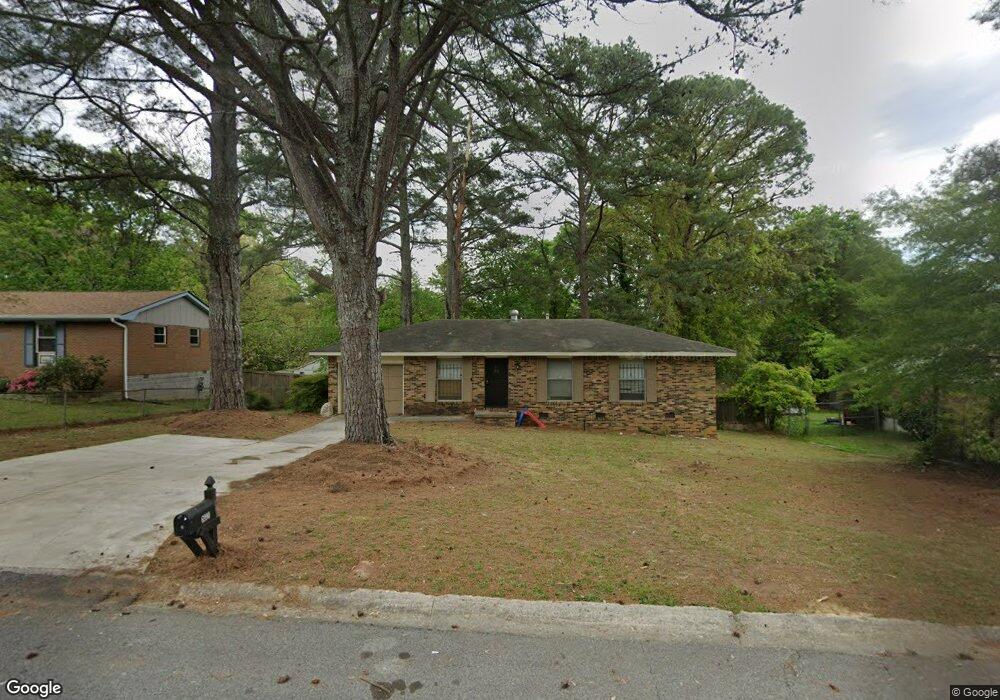
6990 Adel Ln Riverdale, GA 30274
Estimated Value: $177,780 - $219,000
3
Beds
1
Bath
1,092
Sq Ft
$181/Sq Ft
Est. Value
About This Home
This home is located at 6990 Adel Ln, Riverdale, GA 30274 and is currently estimated at $198,195, approximately $181 per square foot. 6990 Adel Ln is a home located in Clayton County with nearby schools including Riverdale Elementary School, Sequoyah Middle School, and Charles R. Drew High School.
Ownership History
Date
Name
Owned For
Owner Type
Purchase Details
Closed on
Jan 12, 2021
Sold by
Ritt Corp Ceo Ronnie Holt
Bought by
Rttt Corp
Current Estimated Value
Purchase Details
Closed on
Dec 30, 2011
Sold by
The Ronnie Holt Stanby & D
Bought by
Corp Rttt
Purchase Details
Closed on
Feb 27, 2002
Sold by
Kent Antionett
Bought by
Holt Bonnie
Home Financials for this Owner
Home Financials are based on the most recent Mortgage that was taken out on this home.
Original Mortgage
$74,250
Interest Rate
8.7%
Mortgage Type
New Conventional
Purchase Details
Closed on
Apr 28, 1997
Sold by
Mcdougal Suzanne S
Bought by
Kent Antionete
Home Financials for this Owner
Home Financials are based on the most recent Mortgage that was taken out on this home.
Original Mortgage
$62,534
Interest Rate
7.95%
Mortgage Type
FHA
Create a Home Valuation Report for This Property
The Home Valuation Report is an in-depth analysis detailing your home's value as well as a comparison with similar homes in the area
Home Values in the Area
Average Home Value in this Area
Purchase History
| Date | Buyer | Sale Price | Title Company |
|---|---|---|---|
| Rttt Corp | -- | -- | |
| Corp Rttt | -- | -- | |
| Holt Bonnie | $85,200 | -- | |
| Kent Antionete | $63,000 | -- |
Source: Public Records
Mortgage History
| Date | Status | Borrower | Loan Amount |
|---|---|---|---|
| Previous Owner | Holt Bonnie | $74,250 | |
| Previous Owner | Kent Antionete | $62,534 |
Source: Public Records
Tax History Compared to Growth
Tax History
| Year | Tax Paid | Tax Assessment Tax Assessment Total Assessment is a certain percentage of the fair market value that is determined by local assessors to be the total taxable value of land and additions on the property. | Land | Improvement |
|---|---|---|---|---|
| 2024 | $2,243 | $56,600 | $6,400 | $50,200 |
| 2023 | $1,438 | $51,160 | $6,400 | $44,760 |
| 2022 | $1,599 | $39,840 | $6,400 | $33,440 |
| 2021 | $1,342 | $33,080 | $6,400 | $26,680 |
| 2020 | $1,107 | $26,814 | $6,400 | $20,414 |
| 2019 | $1,010 | $24,012 | $5,600 | $18,412 |
| 2018 | $926 | $21,946 | $5,600 | $16,346 |
| 2017 | $782 | $18,350 | $5,600 | $12,750 |
| 2016 | $790 | $18,562 | $5,600 | $12,962 |
| 2015 | $867 | $0 | $0 | $0 |
| 2014 | $825 | $19,854 | $5,600 | $14,254 |
Source: Public Records
Map
Nearby Homes
- 6977 Eunice Dr
- 378 Brookview Dr
- 7053 Eunice Dr
- 7112 Brookview Way
- 150 Brookview Dr
- 7109 Brookview Way
- 175 Slicky Rock Ct
- 255 Tara Woods Dr
- 6847 Oak View Ct
- 239 Slicky Rock Ct
- 7086 Williamsburg Dr
- 290 Valley Hill Rd SW
- 7087 Apache Ln
- 242 Shenandoah Dr
- 295 Valley Hill Rd SW
- 6888 Mountain Cir
- 7103 Apache Ln
- 7157 Williamsburg Dr
- 7190 Williamsburg Dr
- 6860 Mountain Cir