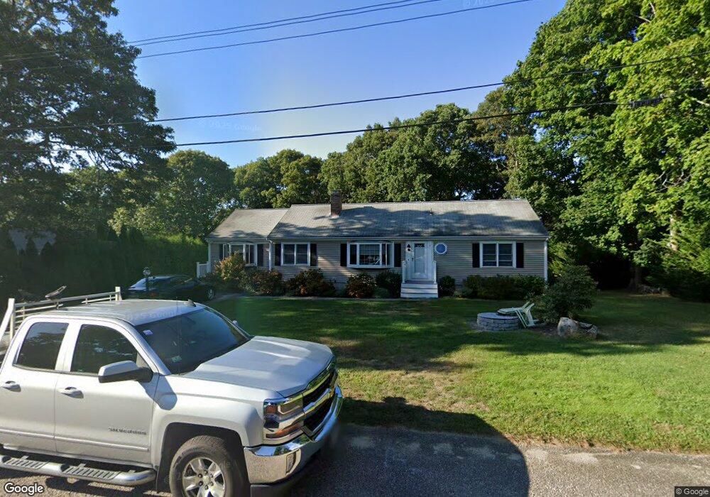
7 Anchor Ln Dennis, MA 02638
East Dennis NeighborhoodEstimated Value: $718,432 - $839,000
3
Beds
2
Baths
1,201
Sq Ft
$644/Sq Ft
Est. Value
About This Home
This home is located at 7 Anchor Ln, Dennis, MA 02638 and is currently estimated at $773,358, approximately $643 per square foot. 7 Anchor Ln is a home located in Barnstable County with nearby schools including Dennis-Yarmouth Regional High School.
Ownership History
Date
Name
Owned For
Owner Type
Purchase Details
Closed on
Jun 4, 2004
Sold by
Decelles David G and Decelles Marjorie M
Bought by
Stone Nancy M
Current Estimated Value
Purchase Details
Closed on
Jan 3, 1994
Sold by
Forbes Russell
Bought by
Decelles David G and Decelles Marjorie M
Create a Home Valuation Report for This Property
The Home Valuation Report is an in-depth analysis detailing your home's value as well as a comparison with similar homes in the area
Home Values in the Area
Average Home Value in this Area
Purchase History
| Date | Buyer | Sale Price | Title Company |
|---|---|---|---|
| Stone Nancy M | $395,000 | -- | |
| Decelles David G | $125,000 | -- |
Source: Public Records
Mortgage History
| Date | Status | Borrower | Loan Amount |
|---|---|---|---|
| Previous Owner | Decelles David G | $132,000 | |
| Previous Owner | Decelles David G | $68,000 | |
| Previous Owner | Decelles David G | $102,600 | |
| Previous Owner | Decelles David G | $20,000 |
Source: Public Records
Tax History
| Year | Tax Paid | Tax Assessment Tax Assessment Total Assessment is a certain percentage of the fair market value that is determined by local assessors to be the total taxable value of land and additions on the property. | Land | Improvement |
|---|---|---|---|---|
| 2025 | $2,899 | $669,600 | $184,800 | $484,800 |
| 2024 | $2,799 | $637,600 | $177,700 | $459,900 |
| 2023 | $2,708 | $579,800 | $161,600 | $418,200 |
| 2022 | $2,549 | $455,100 | $145,500 | $309,600 |
| 2021 | $6,441 | $402,400 | $142,700 | $259,700 |
| 2020 | $2,309 | $378,500 | $142,700 | $235,800 |
| 2019 | $2,237 | $362,500 | $152,600 | $209,900 |
| 2018 | $2,147 | $338,700 | $145,300 | $193,400 |
| 2017 | $1,971 | $320,500 | $133,200 | $187,300 |
| 2016 | $2,033 | $311,300 | $151,300 | $160,000 |
| 2015 | $1,992 | $311,300 | $151,300 | $160,000 |
| 2014 | $1,862 | $293,200 | $133,200 | $160,000 |
Source: Public Records
Map
Nearby Homes
- 58 Terrace Hill Dr
- 61 Terrace Hill Dr
- 930 Old Bass River Rd
- 31 High Head Rd
- 276 Scargo Hill Rd
- 32 Captain Walsh Dr
- 35 Crown Grant Dr
- 102 Prince Way
- 15 Signal Hill Dr
- 6 Thomas Ct
- 645 Main St Back Lot
- 1354 Route 134
- 39 Whittier Dr
- 26 S West Dr
- 19 Deacon Joseph Ln
- 480 Main St
- 59 Hope Ln
- 268 Main St
- 1706 Massachusetts 6a Unit 18
- 1706 Route 6a Unit 18
Your Personal Tour Guide
Ask me questions while you tour the home.