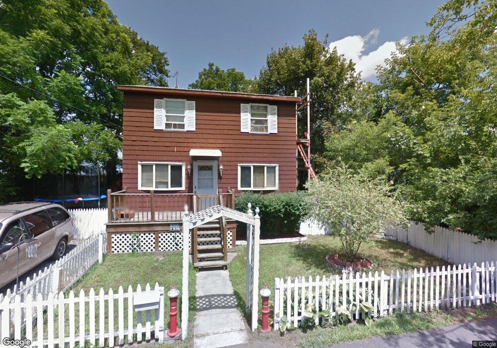
7 Ann St Warwick, RI 02889
Oakland Beach NeighborhoodEstimated Value: $330,060 - $368,000
3
Beds
1
Bath
1,000
Sq Ft
$351/Sq Ft
Est. Value
About This Home
This home is located at 7 Ann St, Warwick, RI 02889 and is currently estimated at $350,515, approximately $350 per square foot. 7 Ann St is a home located in Kent County with nearby schools including Saint Kevin School and Bishop Hendricken High School.
Ownership History
Date
Name
Owned For
Owner Type
Purchase Details
Closed on
Jun 12, 1990
Sold by
Maquire Edward
Bought by
Venticinque Vincent T
Current Estimated Value
Home Financials for this Owner
Home Financials are based on the most recent Mortgage that was taken out on this home.
Original Mortgage
$34,910
Interest Rate
10.39%
Mortgage Type
Purchase Money Mortgage
Create a Home Valuation Report for This Property
The Home Valuation Report is an in-depth analysis detailing your home's value as well as a comparison with similar homes in the area
Home Values in the Area
Average Home Value in this Area
Purchase History
| Date | Buyer | Sale Price | Title Company |
|---|---|---|---|
| Venticinque Vincent T | $54,000 | -- | |
| Venticinque Vincent T | $54,000 | -- |
Source: Public Records
Mortgage History
| Date | Status | Borrower | Loan Amount |
|---|---|---|---|
| Open | Venticinque Vincent T | $145,000 | |
| Closed | Venticinque Vincent T | $110,000 | |
| Closed | Venticinque Vincent T | $34,910 |
Source: Public Records
Tax History
| Year | Tax Paid | Tax Assessment Tax Assessment Total Assessment is a certain percentage of the fair market value that is determined by local assessors to be the total taxable value of land and additions on the property. | Land | Improvement |
|---|---|---|---|---|
| 2025 | $3,513 | $276,600 | $113,000 | $163,600 |
| 2024 | $3,272 | $226,100 | $98,300 | $127,800 |
| 2023 | $3,208 | $226,100 | $98,300 | $127,800 |
| 2022 | $2,957 | $157,900 | $56,900 | $101,000 |
| 2021 | $2,957 | $157,900 | $56,900 | $101,000 |
| 2020 | $2,957 | $157,900 | $56,900 | $101,000 |
| 2019 | $2,957 | $157,900 | $56,900 | $101,000 |
| 2018 | $2,783 | $133,800 | $56,900 | $76,900 |
| 2017 | $2,708 | $133,800 | $56,900 | $76,900 |
| 2016 | $2,708 | $133,800 | $56,900 | $76,900 |
| 2015 | $2,793 | $134,600 | $54,400 | $80,200 |
| 2014 | $2,700 | $134,600 | $54,400 | $80,200 |
| 2013 | $2,664 | $134,600 | $54,400 | $80,200 |
Source: Public Records
Map
Nearby Homes
- 15 Center Ct
- 53 Marblehead St
- 43 Beaver Ave
- 357 Warwick Neck Ave
- 9 Chelmsford Ave
- 30 White Rock Rd
- 96 Burgoyne Dr
- 31 Oakhurst Ave
- 00 Grove Ave
- 47 Clara Ave
- 19 Beatrice Ave
- 71 Pinehurst Ave
- 14 Beatrice Ave
- 299 Palmer Ave
- 75 Northup St
- 320 Palmer Ave
- 9 Kenneth Ave
- 86 Glen Dr
- 123 Payton Ave
- 66 Medford St