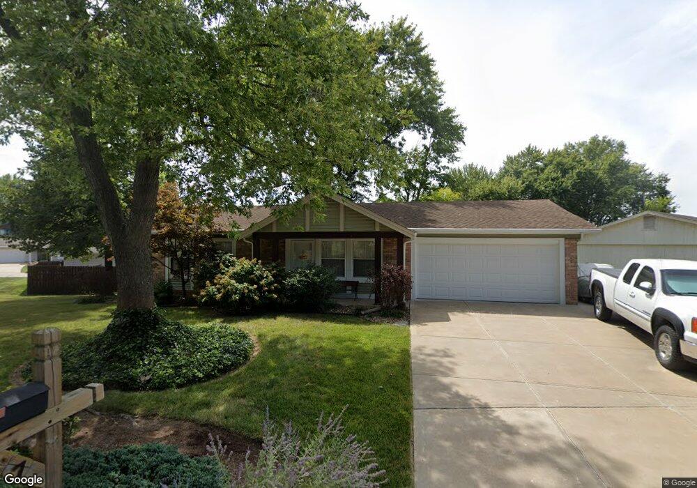
7 Avocado Tree Cir Saint Peters, MO 63376
Estimated Value: $270,000 - $283,000
3
Beds
2
Baths
1,026
Sq Ft
$268/Sq Ft
Est. Value
About This Home
This home is located at 7 Avocado Tree Cir, Saint Peters, MO 63376 and is currently estimated at $274,709, approximately $267 per square foot. 7 Avocado Tree Cir is a home located in St. Charles County with nearby schools including Hawthorn Elementary School, Dr. Bernard J. Dubray Middle School, and Fort Zumwalt East High School.
Ownership History
Date
Name
Owned For
Owner Type
Purchase Details
Closed on
Dec 6, 2002
Sold by
Williams Wanda L
Bought by
Schaefer Harold J
Current Estimated Value
Home Financials for this Owner
Home Financials are based on the most recent Mortgage that was taken out on this home.
Original Mortgage
$102,000
Outstanding Balance
$43,214
Interest Rate
6.05%
Estimated Equity
$231,495
Purchase Details
Closed on
Sep 16, 2002
Sold by
Liv Williams Wanda L and Liv Wanda L Williams Revocable
Bought by
Williams Wanda L
Purchase Details
Closed on
Jul 13, 2001
Sold by
Williams Wanda L
Bought by
Liv Williams Wanda L and Liv Wanda L Williams Revocable
Create a Home Valuation Report for This Property
The Home Valuation Report is an in-depth analysis detailing your home's value as well as a comparison with similar homes in the area
Home Values in the Area
Average Home Value in this Area
Purchase History
| Date | Buyer | Sale Price | Title Company |
|---|---|---|---|
| Schaefer Harold J | $127,500 | -- | |
| Williams Wanda L | -- | -- | |
| Liv Williams Wanda L | -- | -- |
Source: Public Records
Mortgage History
| Date | Status | Borrower | Loan Amount |
|---|---|---|---|
| Open | Schaefer Harold J | $102,000 | |
| Closed | Schaefer Harold J | $12,750 |
Source: Public Records
Tax History
| Year | Tax Paid | Tax Assessment Tax Assessment Total Assessment is a certain percentage of the fair market value that is determined by local assessors to be the total taxable value of land and additions on the property. | Land | Improvement |
|---|---|---|---|---|
| 2025 | $2,568 | $39,105 | -- | -- |
| 2023 | $2,565 | $35,822 | $0 | $0 |
| 2022 | $2,349 | $30,708 | $0 | $0 |
| 2021 | $2,345 | $30,708 | $0 | $0 |
| 2020 | $2,291 | $29,072 | $0 | $0 |
| 2019 | $2,285 | $29,072 | $0 | $0 |
| 2018 | $2,053 | $25,054 | $0 | $0 |
| 2017 | $2,044 | $25,054 | $0 | $0 |
| 2016 | $1,828 | $22,330 | $0 | $0 |
| 2015 | $1,713 | $22,330 | $0 | $0 |
| 2014 | $1,705 | $21,795 | $0 | $0 |
Source: Public Records
Map
Nearby Homes
- 100 Gailwood Dr
- 758 Delray Dr Unit H
- 796 Delray Dr Unit J
- 88 Spencer Trail
- 4011 Kathleen Place
- 1824 Elm Tree St
- 1359 Ticonderoga Dr
- 26 Vanguard Dr
- 1504 Ticonderoga Dr
- 12 Voyager Dr
- 148 Brighton Park Dr
- 537 Sgt Pepper Dr
- 404 Kaliedoscope Ln
- 182 S Brighton Park Ct
- 13 Greenfield Dr
- 101 Woodline Ct
- 268 Spencer Place
- 914 Blake Ct
- 22 Shadow Creek Dr
- 537 Ryehill Dr
- 9 Avocado Tree Cir
- 66 Bartley St
- 9 Avocado Tree Cir
- 68 Bartley St
- 8 Avocado Tree Cir
- 11 Avocado Tree Cir
- 4 Avocado Tree Cir
- 10 Avocado Tree Cir
- 12 Avocado Tree Cir
- 70 Bartley St
- 62 Bartley St
- 13 Avocado Tree Cir
- 67 Bartley St
- 85 Avocado Tree Cir
- 14 Lemon Tree Dr
- 69 Bartley St
- 87 Avocado Tree Cir
- 65 Bartley St
- 16 Lemon Tree Dr
- 12 Lemon Tree Dr
Your Personal Tour Guide
Ask me questions while you tour the home.