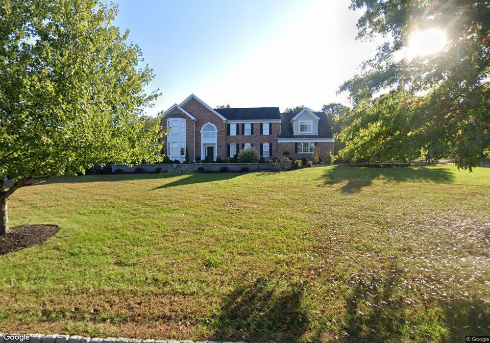
7 Carhart Ct Pittstown, NJ 08867
Estimated Value: $948,000 - $1,199,000
--
Bed
--
Bath
4,227
Sq Ft
$245/Sq Ft
Est. Value
About This Home
This home is located at 7 Carhart Ct, Pittstown, NJ 08867 and is currently estimated at $1,037,098, approximately $245 per square foot. 7 Carhart Ct is a home located in Hunterdon County with nearby schools including Union Township Elementary School, Union Township Middle School, and North Hunterdon High School.
Ownership History
Date
Name
Owned For
Owner Type
Purchase Details
Closed on
Dec 21, 1998
Sold by
Fallone At Highland Ridge Llc
Bought by
Palumbo Gennaro and Palumbo Diane
Current Estimated Value
Home Financials for this Owner
Home Financials are based on the most recent Mortgage that was taken out on this home.
Original Mortgage
$185,000
Outstanding Balance
$42,095
Interest Rate
6.8%
Estimated Equity
$995,003
Create a Home Valuation Report for This Property
The Home Valuation Report is an in-depth analysis detailing your home's value as well as a comparison with similar homes in the area
Home Values in the Area
Average Home Value in this Area
Purchase History
| Date | Buyer | Sale Price | Title Company |
|---|---|---|---|
| Palumbo Gennaro | $365,900 | -- |
Source: Public Records
Mortgage History
| Date | Status | Borrower | Loan Amount |
|---|---|---|---|
| Open | Palumbo Gennaro | $185,000 |
Source: Public Records
Tax History Compared to Growth
Tax History
| Year | Tax Paid | Tax Assessment Tax Assessment Total Assessment is a certain percentage of the fair market value that is determined by local assessors to be the total taxable value of land and additions on the property. | Land | Improvement |
|---|---|---|---|---|
| 2025 | $15,973 | $753,800 | $189,000 | $564,800 |
| 2024 | $16,063 | $753,800 | $189,000 | $564,800 |
| 2023 | $16,063 | $753,800 | $189,000 | $564,800 |
| 2022 | $14,866 | $484,700 | $135,800 | $348,900 |
| 2021 | $13,853 | $484,700 | $135,800 | $348,900 |
| 2020 | $14,211 | $484,700 | $135,800 | $348,900 |
| 2019 | $13,853 | $484,700 | $135,800 | $348,900 |
| 2018 | $13,271 | $484,700 | $135,800 | $348,900 |
| 2017 | $12,830 | $484,700 | $135,800 | $348,900 |
| 2016 | $12,607 | $484,700 | $135,800 | $348,900 |
| 2015 | $12,772 | $484,700 | $135,800 | $348,900 |
| 2014 | $12,845 | $484,700 | $135,800 | $348,900 |
Source: Public Records
Map
Nearby Homes
- 58 Oakwood Blvd
- 759 County Road 625
- Esquire Place Plan at Rolling Hills Estates
- 31 Sam Bonnell Dr
- 22 Sam Bonnell Dr Unit C0204
- 745 County Road 625
- 9 Evergreen Dr
- 19 Crossway Unit 2611A
- 6 Race St
- 89 N Slope
- 140 Driftway E
- 60 Perryville Rd
- 35 Lingert Ave
- 92 Country Acres Dr
- 4 Lingert Ave
- 18 Union Rd
- 0 Baptist Church Rd
- 54 W Main St
- 634 County Road 579
- 69 Baptist Church Rd