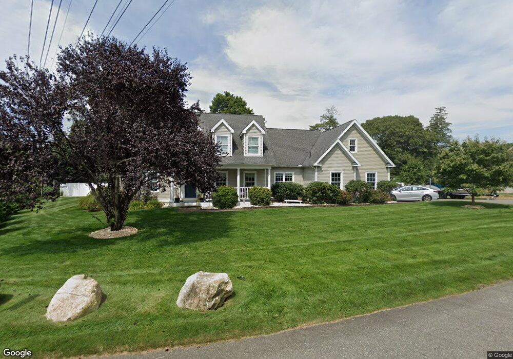
7 Channelside Dr Old Saybrook, CT 06475
Estimated Value: $886,000 - $1,136,000
4
Beds
3
Baths
3,226
Sq Ft
$313/Sq Ft
Est. Value
About This Home
This home is located at 7 Channelside Dr, Old Saybrook, CT 06475 and is currently estimated at $1,010,429, approximately $313 per square foot. 7 Channelside Dr is a home located in Middlesex County with nearby schools including Kathleen E. Goodwin School, Old Saybrook Middle School, and Old Saybrook Senior High School.
Ownership History
Date
Name
Owned For
Owner Type
Purchase Details
Closed on
Dec 7, 2011
Sold by
Schrang Richard A and Schrang Freda
Bought by
Lane Michael and Lane Michelle
Current Estimated Value
Purchase Details
Closed on
Oct 7, 2003
Sold by
Channelside Llc
Bought by
Chapps Christopher and Chapps Kerri
Purchase Details
Closed on
Dec 21, 1992
Sold by
Czaja Stephen T and Czaja Deborah K
Bought by
Lane Michael and Lane Kristen
Create a Home Valuation Report for This Property
The Home Valuation Report is an in-depth analysis detailing your home's value as well as a comparison with similar homes in the area
Home Values in the Area
Average Home Value in this Area
Purchase History
| Date | Buyer | Sale Price | Title Company |
|---|---|---|---|
| Lane Michael | $380,000 | -- | |
| Chapps Christopher | $157,000 | -- | |
| Lane Michael | $150,000 | -- |
Source: Public Records
Mortgage History
| Date | Status | Borrower | Loan Amount |
|---|---|---|---|
| Open | Lane Michael | $432,000 | |
| Closed | Lane Michael | $55,000 | |
| Closed | Lane Michael | $384,000 |
Source: Public Records
Tax History
| Year | Tax Paid | Tax Assessment Tax Assessment Total Assessment is a certain percentage of the fair market value that is determined by local assessors to be the total taxable value of land and additions on the property. | Land | Improvement |
|---|---|---|---|---|
| 2025 | $8,937 | $576,600 | $103,100 | $473,500 |
| 2024 | $8,764 | $576,600 | $103,100 | $473,500 |
| 2023 | $7,362 | $360,000 | $73,300 | $286,700 |
| 2022 | $7,229 | $360,000 | $73,300 | $286,700 |
| 2021 | $7,218 | $360,000 | $73,300 | $286,700 |
| 2020 | $7,218 | $360,000 | $73,300 | $286,700 |
| 2019 | $7,110 | $360,000 | $73,300 | $286,700 |
| 2018 | $6,613 | $337,400 | $69,300 | $268,100 |
| 2017 | $6,690 | $340,300 | $72,200 | $268,100 |
| 2016 | $6,554 | $340,300 | $72,200 | $268,100 |
| 2015 | $6,395 | $340,000 | $72,200 | $267,800 |
| 2014 | $5,602 | $302,800 | $72,200 | $230,600 |
Source: Public Records
Map
Nearby Homes
- 175 Ferry Rd Unit 4
- 96 Ayers Point Rd
- 6 Parkman Place
- 12 Hill Rd
- 62-14,15,16 Middlesex Turnpike
- 1 Huntley Rd
- 1 & 3 Neck Rd
- 0 Middlesex Turnpike
- 8 Lieutenant River Ln
- 3 Ferry Rd
- 34 Lyme St
- 60 Lyme St
- 41 Watrous Point Rd
- Lot 2 - 160 Saybrook Rd
- 11 Essex Hills Dr
- 5 Wyckford Ln Unit 5
- 9 Essex Hills Dr
- 11 Coulter St Unit 28
- 25 Pond Rd
- 125 Main St
Your Personal Tour Guide
Ask me questions while you tour the home.