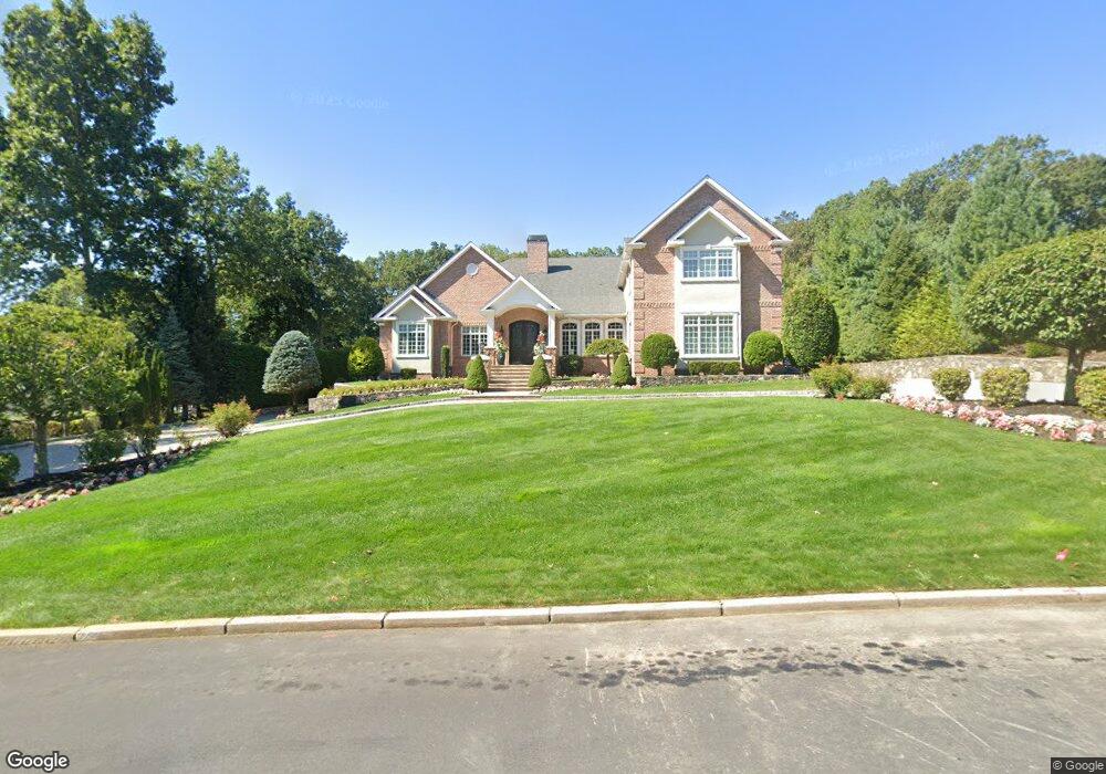
7 Christopher Dr Lincoln, RI 02865
Central Lincoln NeighborhoodEstimated Value: $1,573,000 - $1,710,000
5
Beds
6
Baths
4,712
Sq Ft
$347/Sq Ft
Est. Value
About This Home
This home is located at 7 Christopher Dr, Lincoln, RI 02865 and is currently estimated at $1,634,717, approximately $346 per square foot. 7 Christopher Dr is a home with nearby schools including Lincoln Senior High School, Blackstone Valley Prep Upper Elementary School, and Bishop Keough Regional High School.
Ownership History
Date
Name
Owned For
Owner Type
Purchase Details
Closed on
Mar 6, 2012
Sold by
Grieco Michael A
Bought by
Grieco Domenic R
Current Estimated Value
Home Financials for this Owner
Home Financials are based on the most recent Mortgage that was taken out on this home.
Original Mortgage
$600,000
Interest Rate
3.86%
Create a Home Valuation Report for This Property
The Home Valuation Report is an in-depth analysis detailing your home's value as well as a comparison with similar homes in the area
Home Values in the Area
Average Home Value in this Area
Purchase History
| Date | Buyer | Sale Price | Title Company |
|---|---|---|---|
| Grieco Domenic R | -- | -- |
Source: Public Records
Mortgage History
| Date | Status | Borrower | Loan Amount |
|---|---|---|---|
| Open | Grieco Domenic R | $600,000 | |
| Closed | Grieco Domenic R | $600,000 |
Source: Public Records
Tax History
| Year | Tax Paid | Tax Assessment Tax Assessment Total Assessment is a certain percentage of the fair market value that is determined by local assessors to be the total taxable value of land and additions on the property. | Land | Improvement |
|---|---|---|---|---|
| 2025 | $20,894 | $1,545,400 | $316,700 | $1,228,700 |
| 2024 | $19,399 | $1,118,100 | $301,400 | $816,700 |
| 2023 | $18,437 | $1,118,100 | $301,400 | $816,700 |
| 2022 | $18,393 | $1,118,100 | $301,400 | $816,700 |
| 2021 | $21,345 | $1,052,000 | $243,600 | $808,400 |
| 2020 | $21,187 | $1,052,000 | $243,600 | $808,400 |
| 2018 | $20,636 | $923,300 | $167,400 | $755,900 |
| 2017 | $20,220 | $923,300 | $167,400 | $755,900 |
| 2016 | $19,943 | $923,300 | $167,400 | $755,900 |
| 2015 | $21,057 | $894,900 | $162,500 | $732,400 |
| 2014 | $17,199 | $729,700 | $162,500 | $567,200 |
Source: Public Records
Map
Nearby Homes
- 0 Paddock Dr
- 27 Woodward Rd
- 0 Diesel Dr
- 38 Stone Trail Unit D
- 1445 Old Louisquisset Pike Unit 2A
- 1445 Old Louisquisset Pike Unit 3B
- 1445 Old Louisquisset Pike Unit 4B
- 1445 Old Louisquisset Pike Unit 1B
- 1445 Old Louisquisset Pike Unit 4A
- 1445 Old Louisquisset Pike Unit 2B
- 1445 Old Louisquisset Pike Unit 5A
- 1445 Old Louisquisset Pike Unit 3A
- 48 Arnold Ct Unit A
- 15 Nipmuc Trail Unit A
- 36 Stone Trail Unit C
- 58 Needle Grove Point Unit D
- 18 Pond Ct Unit C
- 72 Hilltop Dr Unit F
- 104 Palmer Dr
- 136 Cobble Hill Rd
Your Personal Tour Guide
Ask me questions while you tour the home.