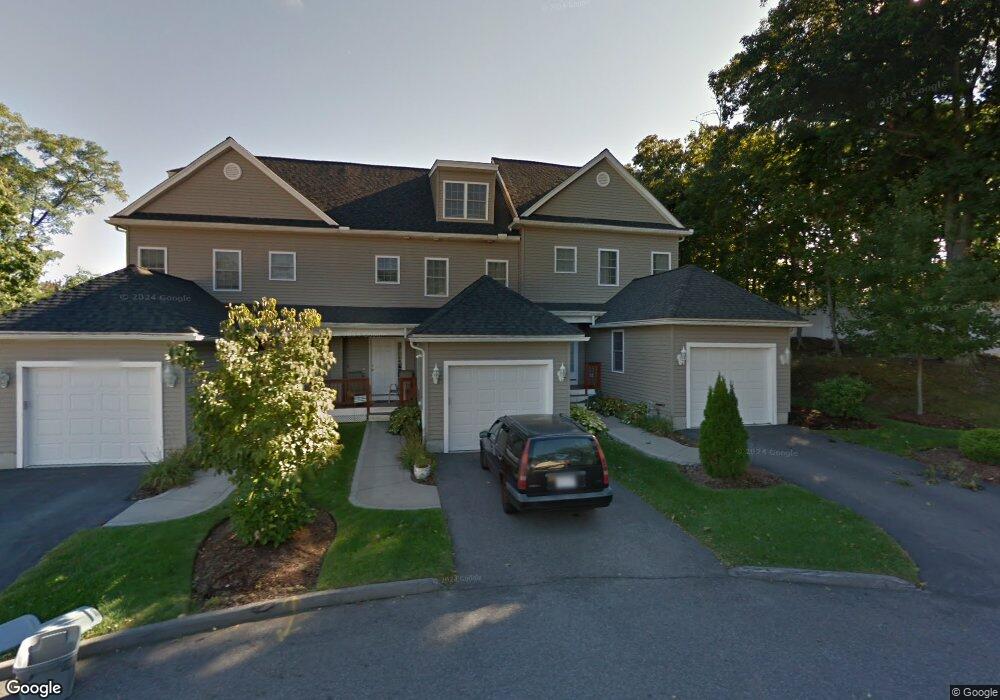
7 Christopher st St Stoneham, MA 02180
Colonial Park NeighborhoodEstimated Value: $362,000 - $594,000
2
Beds
3
Baths
1,723
Sq Ft
$254/Sq Ft
Est. Value
About This Home
This home is located at 7 Christopher st St, Stoneham, MA 02180 and is currently estimated at $436,952, approximately $253 per square foot. 7 Christopher st St is a home located in Middlesex County with nearby schools including Stoneham High School, St. Patrick Elementary School, and Melrose Montessori School.
Ownership History
Date
Name
Owned For
Owner Type
Purchase Details
Closed on
Mar 11, 2016
Sold by
Fucci Joyce A
Bought by
Sokolova Elena
Current Estimated Value
Home Financials for this Owner
Home Financials are based on the most recent Mortgage that was taken out on this home.
Original Mortgage
$156,000
Outstanding Balance
$124,045
Interest Rate
3.79%
Mortgage Type
New Conventional
Estimated Equity
$312,907
Create a Home Valuation Report for This Property
The Home Valuation Report is an in-depth analysis detailing your home's value as well as a comparison with similar homes in the area
Home Values in the Area
Average Home Value in this Area
Purchase History
| Date | Buyer | Sale Price | Title Company |
|---|---|---|---|
| Sokolova Elena | $174,000 | -- |
Source: Public Records
Mortgage History
| Date | Status | Borrower | Loan Amount |
|---|---|---|---|
| Open | Sokolova Elena | $156,000 |
Source: Public Records
Tax History
| Year | Tax Paid | Tax Assessment Tax Assessment Total Assessment is a certain percentage of the fair market value that is determined by local assessors to be the total taxable value of land and additions on the property. | Land | Improvement |
|---|---|---|---|---|
| 2025 | $2,653 | $259,300 | $0 | $259,300 |
| 2024 | $2,623 | $247,700 | $0 | $247,700 |
| 2023 | $2,620 | $236,000 | $0 | $236,000 |
| 2022 | $2,376 | $228,200 | $0 | $228,200 |
| 2021 | $2,344 | $216,600 | $0 | $216,600 |
| 2020 | $2,337 | $216,600 | $0 | $216,600 |
| 2019 | $2,289 | $204,000 | $0 | $204,000 |
| 2018 | $2,061 | $176,000 | $0 | $176,000 |
| 2017 | $2,027 | $163,600 | $0 | $163,600 |
| 2016 | $1,995 | $157,100 | $0 | $157,100 |
| 2015 | $2,024 | $156,200 | $0 | $156,200 |
| 2014 | $2,014 | $149,300 | $0 | $149,300 |
Source: Public Records
Map
Nearby Homes
- 33 Lake Ave
- 159 Franklin St Unit D2
- 159 Franklin St Unit C2
- 159 Franklin St Unit E6
- 53 Perkins St
- 17 Franklin St
- 11 Ludlow Ave
- 137 Franklin St Unit 102
- 5 Chapel Way
- 601 Franklin St Unit 2
- 35 Maple Rd
- 12 Lovis Ave
- 9 Lovis Ave
- 51 Spring St
- 24 Ellsworth Ave
- 23 Ellsworth Ave
- 43-51 Albion St Unit C9
- 34-36 W Highland Ave
- 51 Melrose St Unit 1C
- 51 Melrose St Unit 1A
- 6 Christopher St Unit 6
- 8 Christopher st St
- 6 Christopher st St
- 3 Christopher st St
- 2 Christopher st St
- 1 Christopher st St
- 5 Christopher st St
- 4 Christopher st St
- 5 Christopher St Unit 5
- 7 Walsh Ave
- 9 Walsh Ave
- 0 Christopher St Unit 6 70368539
- 0 Christopher St Unit 5 70368531
- 0 Christopher St Unit 8 70368541
- 0 Christopher St Unit 3 70367546
- 0 Christopher St Unit 4
- 5 Columbus Ave
- 3 Columbus Ave
- 11 Walsh Ave
- 5 Walsh Ave
Your Personal Tour Guide
Ask me questions while you tour the home.