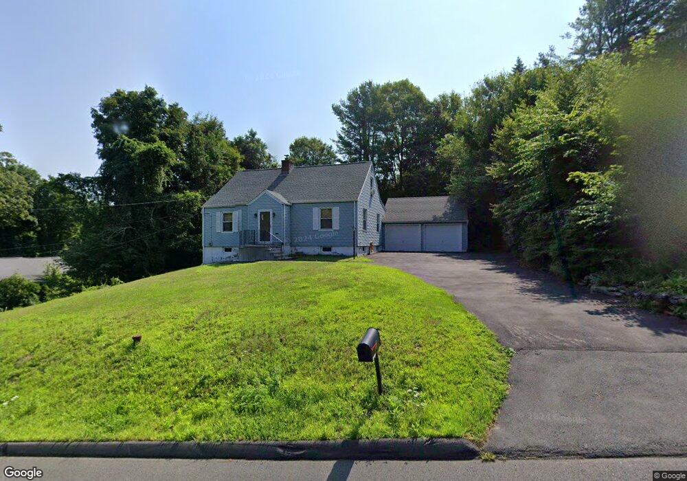
7 Colony Rd Seymour, CT 06483
Estimated Value: $423,000 - $444,000
5
Beds
2
Baths
1,664
Sq Ft
$260/Sq Ft
Est. Value
About This Home
This home is located at 7 Colony Rd, Seymour, CT 06483 and is currently estimated at $432,415, approximately $259 per square foot. 7 Colony Rd is a home located in New Haven County with nearby schools including Seymour Middle School, Seymour High School, and Assumption School.
Ownership History
Date
Name
Owned For
Owner Type
Purchase Details
Closed on
Jun 20, 2018
Sold by
Cedrone Jeffrey
Bought by
Cedrone Amanda
Current Estimated Value
Purchase Details
Closed on
Jul 30, 2007
Sold by
Tenbrink Arthur
Bought by
Cedrone Jeffrey M and Cedrone Amanda R
Home Financials for this Owner
Home Financials are based on the most recent Mortgage that was taken out on this home.
Original Mortgage
$234,000
Interest Rate
6.5%
Mortgage Type
Purchase Money Mortgage
Purchase Details
Closed on
Nov 7, 2003
Sold by
Barilovich Doris Est
Bought by
Tenbrink Arthur R and Tenbrink Christine E
Create a Home Valuation Report for This Property
The Home Valuation Report is an in-depth analysis detailing your home's value as well as a comparison with similar homes in the area
Home Values in the Area
Average Home Value in this Area
Purchase History
| Date | Buyer | Sale Price | Title Company |
|---|---|---|---|
| Cedrone Amanda | -- | -- | |
| Cedrone Jeffrey M | $292,500 | -- | |
| Tenbrink Arthur R | $230,000 | -- | |
| Cedrone Amanda | -- | -- | |
| Cedrone Jeffrey M | $292,500 | -- | |
| Tenbrink Arthur R | $230,000 | -- |
Source: Public Records
Mortgage History
| Date | Status | Borrower | Loan Amount |
|---|---|---|---|
| Previous Owner | Tenbrink Arthur R | $234,000 | |
| Previous Owner | Tenbrink Arthur R | $43,875 |
Source: Public Records
Tax History Compared to Growth
Tax History
| Year | Tax Paid | Tax Assessment Tax Assessment Total Assessment is a certain percentage of the fair market value that is determined by local assessors to be the total taxable value of land and additions on the property. | Land | Improvement |
|---|---|---|---|---|
| 2025 | $7,476 | $269,710 | $46,480 | $223,230 |
| 2024 | $6,643 | $180,320 | $39,480 | $140,840 |
| 2023 | $6,488 | $180,320 | $39,480 | $140,840 |
| 2022 | $6,418 | $180,320 | $39,480 | $140,840 |
| 2021 | $6,259 | $180,320 | $39,480 | $140,840 |
| 2020 | $5,690 | $158,060 | $46,410 | $111,650 |
| 2019 | $5,690 | $158,060 | $46,410 | $111,650 |
| 2018 | $5,690 | $158,060 | $46,410 | $111,650 |
| 2017 | $5,690 | $158,060 | $46,410 | $111,650 |
| 2016 | $5,690 | $158,060 | $46,410 | $111,650 |
| 2015 | $5,392 | $155,890 | $48,720 | $107,170 |
| 2014 | $5,306 | $155,890 | $48,720 | $107,170 |
Source: Public Records
Map
Nearby Homes
- 9 Omar St
- 17 Patton Ave
- 25 Oakwood Dr
- 50 Bellevue Terrace
- 57 Bellevue Terrace
- 169 Derby Ave
- 61 Moss Ave
- 22 Pheasant Dr
- 50 Bissell Place
- 4 Nickel Mine Dr
- 3 Deer Run Dr
- 36 Bungay Terrace
- 17 Warren Dr
- 9 Wooster St
- 77 S Main St
- 129 Old Ansonia Rd
- 72D Walnut St
- 148 Bungay Rd
- 37-14, 49-1, 79-2, 7 Balance Rock Rd
- 26-28 S Main St