Estimated Value: $475,000 - $520,000
3
Beds
1
Bath
936
Sq Ft
$529/Sq Ft
Est. Value
About This Home
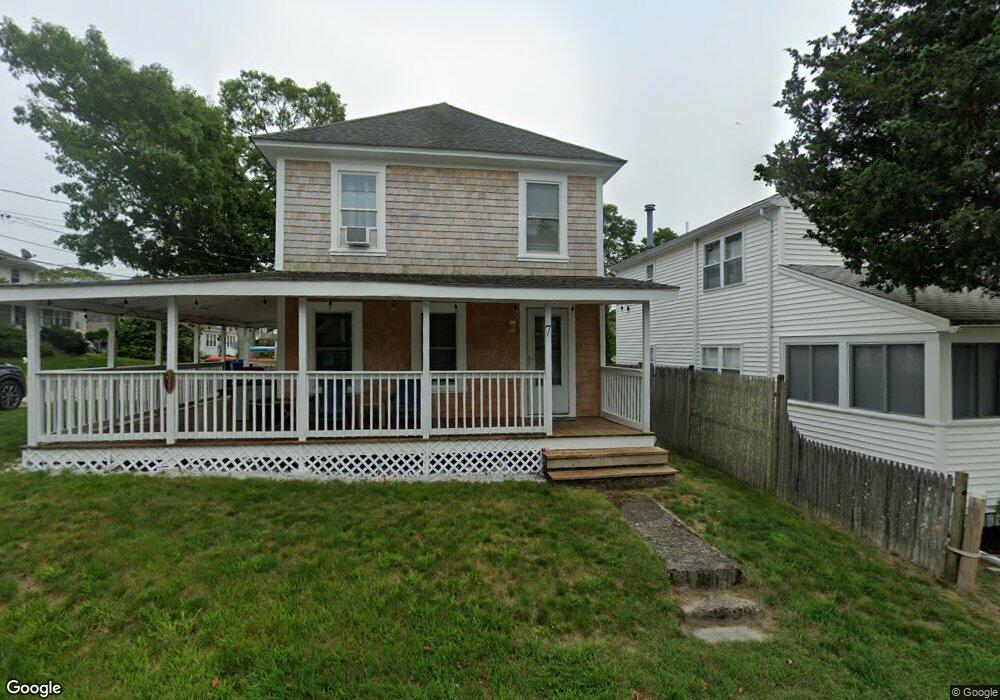
This home is located at 7 Cottonwood Ave, Onset, MA 02558 and is currently estimated at $495,331, approximately $529 per square foot. 7 Cottonwood Ave is a home.
Ownership History
Date
Name
Owned For
Owner Type
Purchase Details
Closed on
Jan 20, 2022
Sold by
Kaipainen John J
Bought by
Manza David J and Mcgraw-Manza Shannon
Current Estimated Value
Home Financials for this Owner
Home Financials are based on the most recent Mortgage that was taken out on this home.
Original Mortgage
$312,000
Outstanding Balance
$286,368
Interest Rate
3.11%
Mortgage Type
Purchase Money Mortgage
Estimated Equity
$208,963
Purchase Details
Closed on
Jan 11, 2013
Sold by
Casey Cheryl and Kaipainen John J
Bought by
Kaipainen John J
Create a Home Valuation Report for This Property
The Home Valuation Report is an in-depth analysis detailing your home's value as well as a comparison with similar homes in the area
Home Values in the Area
Average Home Value in this Area
Purchase History
| Date | Buyer | Sale Price | Title Company |
|---|---|---|---|
| Manza David J | $390,000 | None Available | |
| Manza David J | $390,000 | None Available | |
| Kaipainen John J | -- | -- | |
| Kaipainen John J | -- | -- |
Source: Public Records
Mortgage History
| Date | Status | Borrower | Loan Amount |
|---|---|---|---|
| Open | Manza David J | $312,000 | |
| Closed | Manza David J | $312,000 |
Source: Public Records
Tax History Compared to Growth
Tax History
| Year | Tax Paid | Tax Assessment Tax Assessment Total Assessment is a certain percentage of the fair market value that is determined by local assessors to be the total taxable value of land and additions on the property. | Land | Improvement |
|---|---|---|---|---|
| 2025 | $4,735 | $431,200 | $165,400 | $265,800 |
| 2024 | $4,426 | $378,900 | $121,300 | $257,600 |
| 2023 | $4,140 | $336,600 | $110,300 | $226,300 |
| 2022 | $2,885 | $211,800 | $106,700 | $105,100 |
| 2021 | $2,757 | $196,900 | $106,700 | $90,200 |
| 2020 | $2,645 | $192,900 | $106,700 | $86,200 |
| 2019 | $2,484 | $183,200 | $100,500 | $82,700 |
| 2018 | $2,397 | $170,700 | $100,500 | $70,200 |
| 2017 | $2,479 | $177,300 | $100,500 | $76,800 |
| 2016 | $2,163 | $153,500 | $85,300 | $68,200 |
| 2015 | $2,080 | $151,800 | $85,300 | $66,500 |
| 2014 | $1,990 | $149,700 | $73,100 | $76,600 |
Source: Public Records
Map
Nearby Homes
- 35 Locust St
- 35 Locust St
- 12 Grove St
- 0 Broad St Off Unit 72362523
- 17 Carleton St Unit 17
- 12 Beacon St Unit 84
- 46 Kins Ct
- 45 Kins Ct
- 38 Amos Way
- 26 Highland Ave
- 52 Starboard Dr Unit 36H
- 2 Beacon St Unit 77
- 9 10th St
- 6 Unit 74
- 10 Beacon St Unit 83
- 11 22nd St
- 9 22nd St
- 8 Beacon St Unit 80
- 6 Beacon St Unit 79
- 22 Bay View Ave
- 11 Cottonwood Ave
- 11 Cottonwood Ave
- 13 Cottonwood Ave
- 6 Cottonwood Ave
- 12 Cottonwood Ave
- 4 Dale Ave
- 11 Cottonwood Ave (Summer Weekly)
- 14 Wood St
- 4 Dale Ave
- 15 Dogwood Ln
- 6 Dale Ave Unit 1&2
- 15 Cottonwood Ave
- 4 Locust St
- 6 Dogwood Ln
- 15 Cottonwood Ave
- 16 Cottonwood Ave
- 17 Dogwood Ln
- 8 Dale Ave
- 5 Dale Ave
- 13 Dogwood Ln