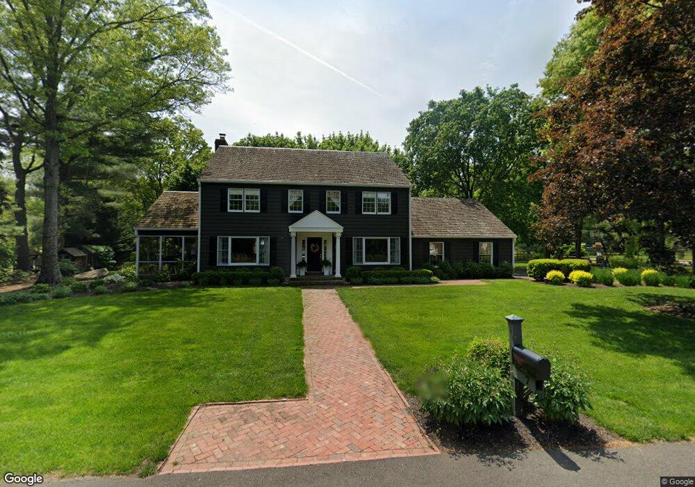
7 Devon Dr New Hope, PA 18938
Estimated Value: $1,060,360 - $1,364,000
4
Beds
5
Baths
3,253
Sq Ft
$372/Sq Ft
Est. Value
About This Home
This home is located at 7 Devon Dr, New Hope, PA 18938 and is currently estimated at $1,209,787, approximately $371 per square foot. 7 Devon Dr is a home located in Bucks County with nearby schools including Sol Feinstone Elementary School, Newtown Middle School, and Council Rock High School North.
Ownership History
Date
Name
Owned For
Owner Type
Purchase Details
Closed on
Jun 23, 1997
Sold by
Lewin Bernard and Lewin Karyn Bangel
Bought by
Malzone John and Malzone Colleen
Current Estimated Value
Home Financials for this Owner
Home Financials are based on the most recent Mortgage that was taken out on this home.
Original Mortgage
$270,000
Interest Rate
8.35%
Create a Home Valuation Report for This Property
The Home Valuation Report is an in-depth analysis detailing your home's value as well as a comparison with similar homes in the area
Home Values in the Area
Average Home Value in this Area
Purchase History
| Date | Buyer | Sale Price | Title Company |
|---|---|---|---|
| Malzone John | $337,500 | T A Title Insurance Company |
Source: Public Records
Mortgage History
| Date | Status | Borrower | Loan Amount |
|---|---|---|---|
| Previous Owner | Malzone John | $270,000 |
Source: Public Records
Tax History
| Year | Tax Paid | Tax Assessment Tax Assessment Total Assessment is a certain percentage of the fair market value that is determined by local assessors to be the total taxable value of land and additions on the property. | Land | Improvement |
|---|---|---|---|---|
| 2025 | $11,290 | $66,000 | $13,080 | $52,920 |
| 2024 | $11,290 | $66,000 | $13,080 | $52,920 |
| 2023 | $10,980 | $66,000 | $13,080 | $52,920 |
| 2022 | $10,923 | $66,000 | $13,080 | $52,920 |
| 2021 | $10,776 | $66,000 | $13,080 | $52,920 |
| 2020 | $10,517 | $66,000 | $13,080 | $52,920 |
| 2019 | $10,274 | $66,000 | $13,080 | $52,920 |
| 2018 | $10,082 | $66,000 | $13,080 | $52,920 |
| 2017 | $9,806 | $66,000 | $13,080 | $52,920 |
| 2016 | $9,954 | $66,000 | $13,080 | $52,920 |
| 2015 | -- | $66,000 | $13,080 | $52,920 |
| 2014 | -- | $66,000 | $13,080 | $52,920 |
Source: Public Records
Map
Nearby Homes
- 14 Devon Dr
- 1324 River Rd
- 1556- 1556A River Rd
- 1556 River Rd
- 10 Bailey Dr
- 38 Lenape Dr
- 1486 River Rd
- 62 Woodside Ln
- 63 Woodside Ln
- 1470 River Rd
- 108 Beaumont Dr
- 1596 River Rd
- 47 Bowmans Dr Unit W
- 104 Dispatch Dr Unit 28A
- 98 Mcconkey Dr
- 1789 Wrightstown Rd
- 1112 General Saint Claire Rd
- 1659 Wrightstown Rd
- 6 Mount View Ct
- 1066 Washington Crossing Rd
Your Personal Tour Guide
Ask me questions while you tour the home.