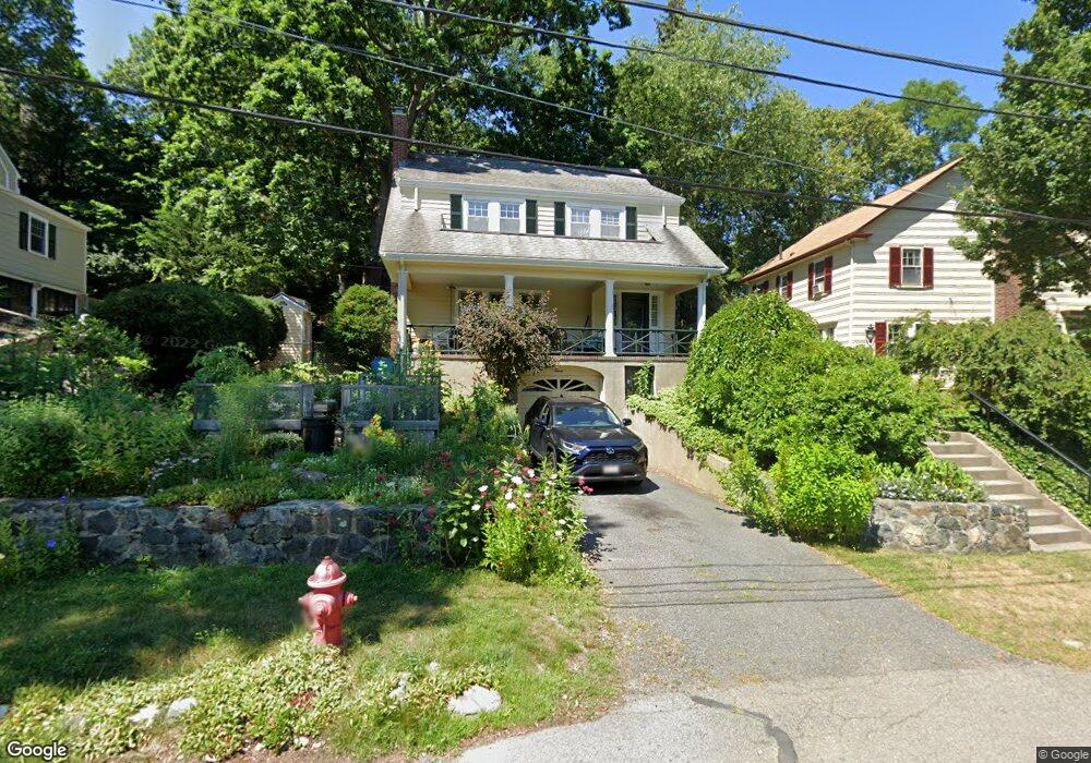
7 Dexter Rd Newtonville, MA 02460
Newtonville NeighborhoodEstimated Value: $1,332,000 - $1,529,000
4
Beds
4
Baths
2,148
Sq Ft
$675/Sq Ft
Est. Value
About This Home
This home is located at 7 Dexter Rd, Newtonville, MA 02460 and is currently estimated at $1,449,053, approximately $674 per square foot. 7 Dexter Rd is a home located in Middlesex County with nearby schools including Cabot Elementary School, F.A. Day Middle School, and Newton North High School.
Ownership History
Date
Name
Owned For
Owner Type
Purchase Details
Closed on
Apr 7, 2025
Sold by
Model Barbara
Bought by
Model Ft and Model
Current Estimated Value
Purchase Details
Closed on
Dec 27, 2018
Sold by
Model Ann Est
Bought by
Model Barbara
Create a Home Valuation Report for This Property
The Home Valuation Report is an in-depth analysis detailing your home's value as well as a comparison with similar homes in the area
Home Values in the Area
Average Home Value in this Area
Purchase History
| Date | Buyer | Sale Price | Title Company |
|---|---|---|---|
| Model Ft | -- | None Available | |
| Model Ft | -- | None Available | |
| Model Barbara | -- | -- | |
| Model Barbara | -- | -- |
Source: Public Records
Tax History Compared to Growth
Tax History
| Year | Tax Paid | Tax Assessment Tax Assessment Total Assessment is a certain percentage of the fair market value that is determined by local assessors to be the total taxable value of land and additions on the property. | Land | Improvement |
|---|---|---|---|---|
| 2025 | $11,672 | $1,191,000 | $1,097,800 | $93,200 |
| 2024 | $11,285 | $1,156,300 | $1,065,800 | $90,500 |
| 2023 | $10,613 | $1,042,500 | $800,700 | $241,800 |
| 2022 | $10,155 | $965,300 | $741,400 | $223,900 |
| 2021 | $9,799 | $910,700 | $699,400 | $211,300 |
| 2020 | $9,508 | $910,700 | $699,400 | $211,300 |
| 2019 | $9,240 | $884,200 | $679,000 | $205,200 |
| 2018 | $8,867 | $819,500 | $618,600 | $200,900 |
| 2017 | $8,597 | $773,100 | $583,600 | $189,500 |
| 2016 | $8,222 | $722,500 | $545,400 | $177,100 |
| 2015 | $7,839 | $675,200 | $509,700 | $165,500 |
Source: Public Records
Map
Nearby Homes
- 61 Lakeview Ave
- 34 Morton Rd
- 887 Commonwealth Ave
- 22 Walnut Place Unit 1
- 300 Cabot St
- 3 Cedar St
- 127-129 Withington Rd Unit 1
- 10 Washington Park
- 10 Washington Park Unit 2
- 10 Washington Park Unit 1
- 110 Harvard St Unit A
- 97 Valentine St
- 123-125 Mount Vernon St
- 123 Mount Vernon St Unit 2
- 44 Blake St Unit 2
- 911 Washington St
- 935 Washington St Unit 8
- 957 Washington St Unit 1
- 308 Prince St
- 73 Elmore St
- 44 Hull St
- 15 Dexter Rd
- 48 Hull St
- 42 Prospect Park
- 10 Dexter Rd Unit 12
- 10 Dexter Rd Unit 2
- 34 Prospect Park
- 54 Hull St
- 54 Hull St
- 20 Dexter Rd
- 58 Prospect Park Unit 58
- 58 Prospect Park Unit 60
- 58 Prospect Park Unit 2
- 26 Dexter Rd
- 60 Hull St
- 24 Prospect Park
- 543 Walnut St
- 36 Dexter Rd
- 36 Dexter Rd Unit A
- 525 Walnut St