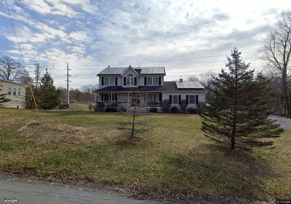
7 E Green Rd Rock Tavern, NY 12575
Estimated Value: $503,000 - $647,000
4
Beds
3
Baths
2,032
Sq Ft
$277/Sq Ft
Est. Value
About This Home
This home is located at 7 E Green Rd, Rock Tavern, NY 12575 and is currently estimated at $563,056, approximately $277 per square foot. 7 E Green Rd is a home located in Orange County with nearby schools including Washingtonville Middle School, Washingtonville High School, and The Birch School.
Ownership History
Date
Name
Owned For
Owner Type
Purchase Details
Closed on
Sep 6, 2007
Sold by
Kenary Michael
Bought by
Gallagher David
Current Estimated Value
Purchase Details
Closed on
Jan 3, 2002
Sold by
Latimer John M
Bought by
Kenary Michael and Kenary Jeannine
Purchase Details
Closed on
Jul 27, 1999
Sold by
Bracco Margery G
Bought by
Latimer John M
Purchase Details
Closed on
Aug 25, 1998
Sold by
Warth Dorothy G and Bracco Margery G
Bought by
Bracco Margery G
Purchase Details
Closed on
Nov 21, 1997
Sold by
Bracco Margery G and Green Elsie D
Bought by
Warth Dorothy G and Bracco Margery G
Create a Home Valuation Report for This Property
The Home Valuation Report is an in-depth analysis detailing your home's value as well as a comparison with similar homes in the area
Home Values in the Area
Average Home Value in this Area
Purchase History
We collect this data history from publicly available records. To have your information removed, we recommend requesting removal directly through your county’s website.
| Date | Buyer | Sale Price | Title Company |
|---|---|---|---|
| Gallagher David | $355,000 | Gary Goldstein | |
| Kenary Michael | $38,000 | Fidelity National Title Ins | |
| Latimer John M | $4,000 | First American Title Ins Co | |
| Bracco Margery G | -- | First American Title Ins Co | |
| Warth Dorothy G | -- | -- |
Source: Public Records
Tax History
| Year | Tax Paid | Tax Assessment Tax Assessment Total Assessment is a certain percentage of the fair market value that is determined by local assessors to be the total taxable value of land and additions on the property. | Land | Improvement |
|---|---|---|---|---|
| 2025 | $11,128 | $51,400 | $9,000 | $42,400 |
| 2024 | $11,127 | $51,400 | $9,000 | $42,400 |
| 2023 | $11,127 | $51,400 | $9,000 | $42,400 |
| 2022 | $11,283 | $51,400 | $9,000 | $42,400 |
| 2021 | $11,227 | $51,400 | $9,000 | $42,400 |
| 2020 | $9,958 | $51,400 | $9,000 | $42,400 |
| 2019 | $9,772 | $51,400 | $9,000 | $42,400 |
| 2018 | $9,772 | $51,400 | $9,000 | $42,400 |
| 2017 | $9,365 | $51,400 | $9,000 | $42,400 |
| 2016 | $9,025 | $51,400 | $9,000 | $42,400 |
| 2015 | -- | $51,400 | $9,000 | $42,400 |
| 2014 | -- | $51,400 | $9,000 | $42,400 |
Source: Public Records
Map
Nearby Homes
- 27 E Green Rd
- 51 E Green Rd
- 1 Stone Arch Manor Rd
- 629 Twin Arch Rd
- 600 Twin Arch Rd
- 2398 State Route 207
- 89 James Wilkinson Rd
- 181 Twin Arch Rd
- 0 New York 208 Unit KEY981300
- 0 New York 208 Unit KEY923275
- 9 Karen Ct
- 3431 State Route 208
- L 14.22 Ws of Route 208
- 218 Beattie Rd
- 302 Tower Ave
- 9 Megan Ln
- 3368 New York 208
- 307 Tower Ave
- 311 Tower Ave
- 708 Tower Ave
- 1 E Green Rd
- 11 E Green Rd
- 2 E Green Rd
- 15 E Green Rd
- 16 E Green Rd
- 2104 Little Britain Rd
- 2173 Little Britain Rd
- 2106 Little Britain Rd
- 22 E Green Rd
- 2177 Little Britain Rd
- 26 E Green Rd
- 671 Twin Arch Rd
- 2301 State Route 207
- 2301 State Route 207
- 673 Twin Arch Rd
- 669 Twin Arch Rd
- 10 Stone Arch Manor Rd
- 3 W Green Rd
- 9 Stone Arch Manor Rd
- 2084 Little Britain Rd
Your Personal Tour Guide
Ask me questions while you tour the home.