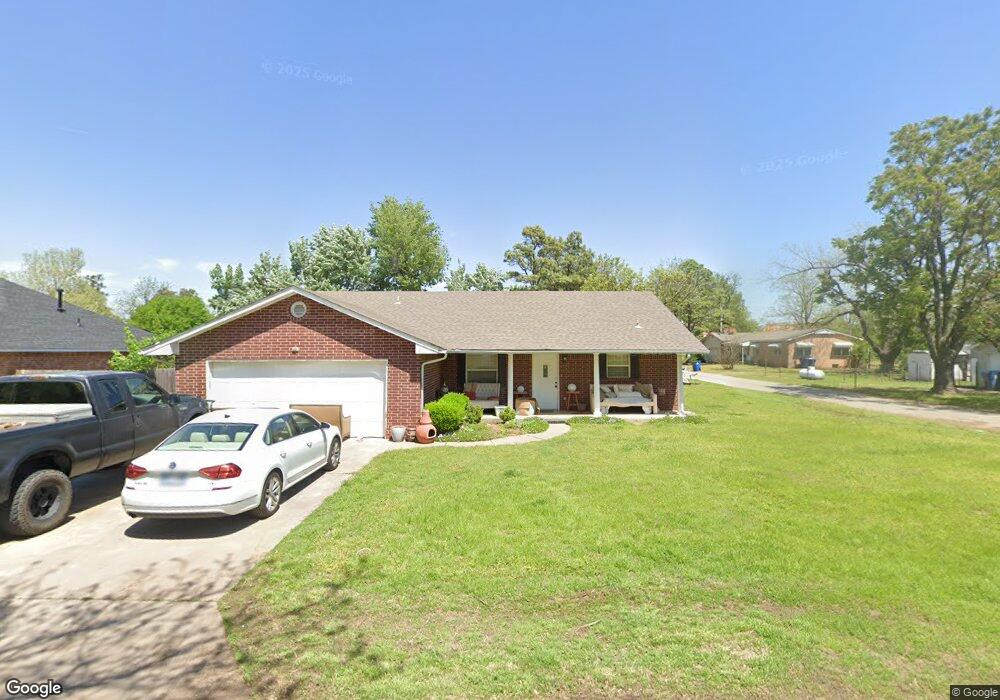
7 E Locust St Tuttle, OK 73089
Estimated Value: $206,000 - $249,000
3
Beds
2
Baths
1,496
Sq Ft
$154/Sq Ft
Est. Value
About This Home
This home is located at 7 E Locust St, Tuttle, OK 73089 and is currently estimated at $230,709, approximately $154 per square foot. 7 E Locust St is a home located in Grady County with nearby schools including Tuttle Intermediate School, Tuttle Elementary School, and Tuttle Middle School.
Ownership History
Date
Name
Owned For
Owner Type
Purchase Details
Closed on
Nov 4, 2014
Sold by
Koch Christina S and Koch Just
Bought by
Garrett Rental Llc
Current Estimated Value
Purchase Details
Closed on
Mar 6, 2010
Sold by
Pearce Dusti
Bought by
Koch Christina S and Koch Just
Purchase Details
Closed on
Sep 21, 2009
Sold by
Bank Of Oklahoma Na
Bought by
Greenroyd Ella
Purchase Details
Closed on
Jun 23, 2009
Sold by
Collins Jared Cole
Bought by
Bank Of Oklahoma Na and Bok Mortgage
Purchase Details
Closed on
Jan 30, 2007
Sold by
Morrison Charles L and Morrison April N
Bought by
Collins Jared Cole
Home Financials for this Owner
Home Financials are based on the most recent Mortgage that was taken out on this home.
Original Mortgage
$115,360
Interest Rate
6.13%
Mortgage Type
New Conventional
Create a Home Valuation Report for This Property
The Home Valuation Report is an in-depth analysis detailing your home's value as well as a comparison with similar homes in the area
Home Values in the Area
Average Home Value in this Area
Purchase History
| Date | Buyer | Sale Price | Title Company |
|---|---|---|---|
| Garrett Rental Llc | $130,000 | -- | |
| Koch Christina S | $119,000 | -- | |
| Greenroyd Ella | $101,000 | None Available | |
| Bank Of Oklahoma Na | $119,310 | None Available | |
| Collins Jared Cole | $112,000 | None Available |
Source: Public Records
Mortgage History
| Date | Status | Borrower | Loan Amount |
|---|---|---|---|
| Previous Owner | Collins Jared Cole | $115,360 |
Source: Public Records
Tax History
| Year | Tax Paid | Tax Assessment Tax Assessment Total Assessment is a certain percentage of the fair market value that is determined by local assessors to be the total taxable value of land and additions on the property. | Land | Improvement |
|---|---|---|---|---|
| 2025 | $1,640 | $15,566 | $820 | $14,746 |
| 2024 | $1,684 | $14,825 | $781 | $14,044 |
| 2023 | $1,684 | $14,119 | $900 | $13,219 |
| 2022 | $1,467 | $13,359 | $839 | $12,520 |
| 2021 | $1,510 | $13,691 | $839 | $12,852 |
| 2020 | $1,534 | $13,769 | $839 | $12,930 |
| 2019 | $1,526 | $13,934 | $839 | $13,095 |
| 2018 | $1,445 | $13,969 | $839 | $13,130 |
| 2017 | $1,495 | $14,091 | $839 | $13,252 |
| 2016 | $1,540 | $14,257 | $839 | $13,418 |
| 2015 | $1,239 | $14,300 | $839 | $13,461 |
| 2014 | $1,239 | $13,090 | $660 | $12,430 |
Source: Public Records
Map
Nearby Homes
- 104 SE 2nd St
- 605 SW 4th St
- 502 SW 5th St
- 2 NW 6th St
- 309 Elm St
- 311 N Cimarron Rd
- 10 Westend Ct
- 516 Kings Ct
- 1 NW 7th St
- 106 Englebretson Ln
- 901 N Cimarron Rd
- 2025 E Rock Creek Rd
- 1301 E Rock Creek Rd
- 1260 E Rock Creek Rd
- 903 County Street 2910
- 1874 E Rock Creek Rd
- 601 S Frisco Rd
- 1300 Ella
- 0 Frisco Rd
- 1330 E Silver City Ridge
Your Personal Tour Guide
Ask me questions while you tour the home.