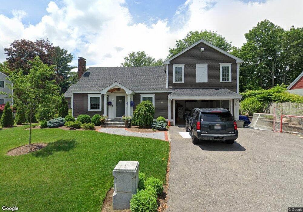
7 Fiske St Natick, MA 01760
Estimated Value: $991,000 - $1,074,000
4
Beds
2
Baths
1,464
Sq Ft
$715/Sq Ft
Est. Value
About This Home
This home is located at 7 Fiske St, Natick, MA 01760 and is currently estimated at $1,047,256, approximately $715 per square foot. 7 Fiske St is a home located in Middlesex County with nearby schools including Natick High School, Johnson Elementary School, and J F Kennedy Middle School.
Ownership History
Date
Name
Owned For
Owner Type
Purchase Details
Closed on
Apr 30, 2013
Sold by
7 Fiske Street Rt
Bought by
Emily S Indresano Lt
Current Estimated Value
Home Financials for this Owner
Home Financials are based on the most recent Mortgage that was taken out on this home.
Original Mortgage
$275,000
Outstanding Balance
$196,261
Interest Rate
3.64%
Mortgage Type
New Conventional
Estimated Equity
$850,995
Purchase Details
Closed on
Nov 9, 2012
Sold by
Scott Emily
Bought by
7 Fiske Street Rt
Purchase Details
Closed on
Jun 5, 2008
Sold by
Fitzgerald Rt
Bought by
Scott Emily and Scott Emily A
Home Financials for this Owner
Home Financials are based on the most recent Mortgage that was taken out on this home.
Original Mortgage
$245,000
Interest Rate
6.11%
Mortgage Type
Purchase Money Mortgage
Purchase Details
Closed on
May 31, 2006
Sold by
Fitzgerald Shirley J
Bought by
Fitzgerald Rt
Create a Home Valuation Report for This Property
The Home Valuation Report is an in-depth analysis detailing your home's value as well as a comparison with similar homes in the area
Home Values in the Area
Average Home Value in this Area
Purchase History
| Date | Buyer | Sale Price | Title Company |
|---|---|---|---|
| Emily S Indresano Lt | -- | -- | |
| 7 Fiske Street Rt | -- | -- | |
| Scott Emily | $275,000 | -- | |
| Fitzgerald Rt | -- | -- |
Source: Public Records
Mortgage History
| Date | Status | Borrower | Loan Amount |
|---|---|---|---|
| Open | Emily S Indresano Lt | $275,000 | |
| Previous Owner | Scott Emily | $245,000 |
Source: Public Records
Tax History Compared to Growth
Tax History
| Year | Tax Paid | Tax Assessment Tax Assessment Total Assessment is a certain percentage of the fair market value that is determined by local assessors to be the total taxable value of land and additions on the property. | Land | Improvement |
|---|---|---|---|---|
| 2025 | $10,150 | $848,700 | $442,200 | $406,500 |
| 2024 | $9,726 | $793,300 | $416,200 | $377,100 |
| 2023 | $9,766 | $772,600 | $399,000 | $373,600 |
| 2022 | $9,442 | $707,800 | $361,300 | $346,500 |
| 2021 | $3,376 | $665,200 | $340,700 | $324,500 |
| 2020 | $8,842 | $649,700 | $325,200 | $324,500 |
| 2019 | $3,103 | $649,700 | $325,200 | $324,500 |
| 2018 | $8,224 | $630,200 | $309,700 | $320,500 |
| 2017 | $2,884 | $397,400 | $267,100 | $130,300 |
| 2016 | $5,091 | $375,200 | $246,100 | $129,100 |
| 2015 | $5,037 | $364,500 | $246,100 | $118,400 |
Source: Public Records
Map
Nearby Homes
- 91 Speen St
- 1 Fern St
- 4 Sylvia Ave
- 2 Lodge Rd
- 40 Silver Hill Ln Unit 4
- 16 West St
- 46 Silver Hill Ln Unit 1
- 32 Silver Hill Ln Unit 1
- 9 Silver Hill Ln Unit 19
- 10 Kelsey Rd
- 26 Walden Dr Unit 4
- 12 Walden Dr Unit 19
- 25 Forest Ave
- 38 Ranger Rd
- 47 High St
- 58 W Central St
- 8 Pitts St
- 216-218 S Main St
- 57 Village Brook Ln Unit 5
- 50 Village Brook Ln Unit 4