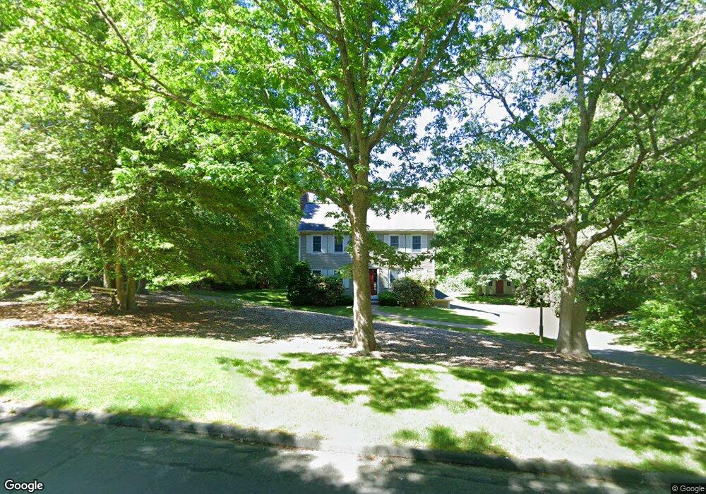
7 Heather Hill Rd Sandwich, MA 02563
Estimated Value: $756,332 - $836,000
4
Beds
3
Baths
2,020
Sq Ft
$388/Sq Ft
Est. Value
About This Home
This home is located at 7 Heather Hill Rd, Sandwich, MA 02563 and is currently estimated at $784,083, approximately $388 per square foot. 7 Heather Hill Rd is a home located in Barnstable County with nearby schools including Sandwich Middle High School and Sandwich Montessori School.
Ownership History
Date
Name
Owned For
Owner Type
Purchase Details
Closed on
May 6, 2015
Sold by
Lawson Carris A and Lawson Peter J
Bought by
Lawson Peter J and Lawson Carris A
Current Estimated Value
Purchase Details
Closed on
Apr 16, 1986
Bought by
Lawson Peter J and Lawson Carris A
Create a Home Valuation Report for This Property
The Home Valuation Report is an in-depth analysis detailing your home's value as well as a comparison with similar homes in the area
Home Values in the Area
Average Home Value in this Area
Purchase History
| Date | Buyer | Sale Price | Title Company |
|---|---|---|---|
| Lawson Peter J | -- | -- | |
| Lawson Peter J | -- | -- |
Source: Public Records
Tax History Compared to Growth
Tax History
| Year | Tax Paid | Tax Assessment Tax Assessment Total Assessment is a certain percentage of the fair market value that is determined by local assessors to be the total taxable value of land and additions on the property. | Land | Improvement |
|---|---|---|---|---|
| 2025 | $6,781 | $641,500 | $196,000 | $445,500 |
| 2024 | $6,560 | $607,400 | $175,000 | $432,400 |
| 2023 | $6,354 | $552,500 | $159,100 | $393,400 |
| 2022 | $5,994 | $455,500 | $142,000 | $313,500 |
| 2021 | $5,788 | $420,300 | $141,400 | $278,900 |
| 2020 | $5,808 | $405,900 | $141,200 | $264,700 |
| 2019 | $5,538 | $386,700 | $138,600 | $248,100 |
| 2018 | $5,104 | $357,200 | $126,500 | $230,700 |
| 2017 | $5,045 | $337,900 | $122,400 | $215,500 |
| 2016 | $4,752 | $328,400 | $118,400 | $210,000 |
| 2015 | $4,477 | $302,100 | $96,300 | $205,800 |
Source: Public Records
Map
Nearby Homes
- 22 Sconset Cir
- 93 Deerfield Rd
- 59 Southpoint Dr Unit 59
- 96 Pimlico Pond Rd
- 58 Southpoint Dr Unit J
- 185 Cotuit Rd Unit BE4
- 185 Cotuit Rd Unit JP1
- 185 Cotuit Rd Unit C5 Aspen
- 18 Katian Way
- 5 Aviators Ln
- 6 Southfield Ln
- 3 Glenwood Ln
- 544 Cotuit Rd
- 37 Pickerel Way
- 10 Wintergreen Ln
- 6 Santuit Pond Rd
- 15 Hunters Trail
- 15 Hunters Tr
- 7 Open Trail Rd
- 9 Heather Hill Rd
- 5 Heather Hill Rd
- 8 Heather Hill Rd
- 6 Heather Hill Rd
- 6 Bobwhite Ln
- 6 Bob White Ln
- 95 Boardley Rd
- 11 Heather Hill Rd
- 4 Bobwhite Ln
- 4 Bob White Ln
- 4 Heather Hill Rd
- 1 Heather Hill Rd
- 10 Heather Hill Rd
- 105 Boardley Rd
- 9 Viking Ln
- 11 Viking Ln
- 181 Bob White Ln
- 7 Viking Ln
- 8 Bob White Ln
- 8 Bobwhite Ln