


7 Hill St Medway, MA 02053
Estimated payment $4,706/month
Highlights
- In Ground Pool
- Solar Power System
- Property is near public transit
- John D. McGovern Elementary School Rated A-
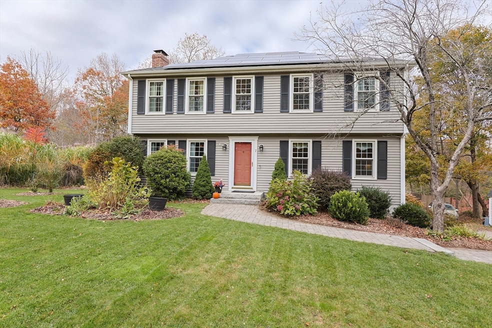
- Colonial Architecture
- Wooded Lot
About This Home
Colonial nestled on a private, wooded lot close to highway and area amenities. Welcoming layout with an eat-in kitchen open to the coffered ceiling family room with wood stove. A large dining room with a bow window opens to the formal living room, creating an ideal flow for entertaining. Off the kitchen is a sunroom with views of the tree-lined yard as well as fruit trees and organic lawn in front yard. Hardwood floors extend to both levels and the second floor offers an ensuite primary bedroom, three other beds and oversized full bath. Important updates include: roof ~ 2 years with Tesla Solar Panels as well as charging port in garage, 200-amp electrical service, 2021 septic system, central air 2022, young well pump. and replacement windows.
Home Details
Home Type
- Single Family
Est. Annual Taxes
- $9,143
Year Built
- Built in 1977
Lot Details
- 1.32 Acre Lot
- Wooded Lot
- Property is zoned AR-1
Parking
- 2 Car Attached Garage
- Garage Door Opener
- Driveway
- Open Parking
- Off-Street Parking
Home Design
- Colonial Architecture
- Frame Construction
- Shingle Roof
- Concrete Perimeter Foundation
Interior Spaces
- 2,069 Sq Ft Home
- Coffered Ceiling
- Ceiling Fan
- 1 Fireplace
- Insulated Windows
- Bay Window
- Dining Area
- Sun or Florida Room
- Screened Porch
- Storm Windows
- Washer and Electric Dryer Hookup
Kitchen
- Range
- Microwave
- Dishwasher
- Solid Surface Countertops
Flooring
- Wood
- Ceramic Tile
Bedrooms and Bathrooms
- 4 Bedrooms
- Primary bedroom located on second floor
- Walk-In Closet
- Bathtub with Shower
- Linen Closet In Bathroom
Basement
- Basement Fills Entire Space Under The House
- Interior Basement Entry
- Garage Access
- Laundry in Basement
Eco-Friendly Details
- Solar Power System
Outdoor Features
- In Ground Pool
- Bulkhead
Location
- Property is near public transit
- Property is near schools
Schools
- Medway Middle School
- Medway High School
Utilities
- Central Air
- 2 Cooling Zones
- 2 Heating Zones
- Heating System Uses Oil
- Pellet Stove burns compressed wood to generate heat
- Baseboard Heating
- 200+ Amp Service
- Private Water Source
- Electric Water Heater
- Private Sewer
- High Speed Internet
Listing and Financial Details
- Assessor Parcel Number 3166321
Community Details
Overview
- No Home Owners Association
- Electric Vehicle Charging Station
Recreation
- Park
- Jogging Path
- Bike Trail
Map
Home Values in the Area
Average Home Value in this Area
Tax History
| Year | Tax Paid | Tax Assessment Tax Assessment Total Assessment is a certain percentage of the fair market value that is determined by local assessors to be the total taxable value of land and additions on the property. | Land | Improvement |
|---|---|---|---|---|
| 2025 | $9,143 | $641,600 | $341,400 | $300,200 |
| 2024 | $9,239 | $641,600 | $341,400 | $300,200 |
| 2023 | $9,159 | $574,600 | $310,900 | $263,700 |
| 2022 | $8,093 | $478,000 | $230,300 | $247,700 |
| 2021 | $8,025 | $459,600 | $215,000 | $244,600 |
| 2020 | $7,882 | $450,400 | $215,000 | $235,400 |
| 2019 | $7,435 | $438,100 | $206,300 | $231,800 |
| 2018 | $7,486 | $423,900 | $197,600 | $226,300 |
| 2017 | $7,693 | $429,300 | $193,300 | $236,000 |
| 2016 | $7,498 | $414,000 | $178,000 | $236,000 |
| 2015 | $7,354 | $403,200 | $175,800 | $227,400 |
| 2014 | $7,359 | $390,600 | $177,400 | $213,200 |
Property History
| Date | Event | Price | List to Sale | Price per Sq Ft |
|---|---|---|---|---|
| 11/15/2025 11/15/25 | Pending | -- | -- | -- |
| 11/10/2025 11/10/25 | For Sale | $749,900 | -- | $362 / Sq Ft |
Purchase History
| Date | Type | Sale Price | Title Company |
|---|---|---|---|
| Deed | $234,000 | -- | |
| Deed | $235,000 | -- |
Mortgage History
| Date | Status | Loan Amount | Loan Type |
|---|---|---|---|
| Open | $233,000 | No Value Available | |
| Closed | $222,300 | Purchase Money Mortgage | |
| Previous Owner | $181,000 | No Value Available | |
| Previous Owner | $185,000 | No Value Available |
Source: MLS Property Information Network (MLS PIN)
MLS Number: 73453305
APN: MEDW-000003-000000-000007
Disclaimer: Certain information contained herein is derived from information provided by parties other than Homes.com. All information provided is deemed reliable, but is not guaranteed to be accurate and should be independently verified.
![]() The property listing data and information, or the Images, set forth herein were provided to MLS Property Information Network, Inc. from third party sources, including sellers, lessors and public records, and were compiled by MLS Property Information Network, Inc. The property listing data and information, and the Images, are for the personal, non-commercial use of consumers having a good faith interest in purchasing or leasing listed properties of the type displayed to them and may not be used for any purpose other than to identify prospective properties which such consumers may have a good faith interest in purchasing or leasing. MLS Property Information Network, Inc. and its subscribers disclaim any and all representations and warranties as to the accuracy of the property listing data and information, or as to the accuracy of any of the Images, set forth herein.
The property listing data and information, or the Images, set forth herein were provided to MLS Property Information Network, Inc. from third party sources, including sellers, lessors and public records, and were compiled by MLS Property Information Network, Inc. The property listing data and information, and the Images, are for the personal, non-commercial use of consumers having a good faith interest in purchasing or leasing listed properties of the type displayed to them and may not be used for any purpose other than to identify prospective properties which such consumers may have a good faith interest in purchasing or leasing. MLS Property Information Network, Inc. and its subscribers disclaim any and all representations and warranties as to the accuracy of the property listing data and information, or as to the accuracy of any of the Images, set forth herein.
- 116 Winthrop St
- 0 Hill St
- 19 Sycamore Way
- 625 Norfolk St
- 30 Broken Tree Rd
- 140 Goulding St
- 1037 Washington St
- 1 Walnut Ln
- 266 Willowgate Rise
- 3 Jameson Dr Unit 3
- 156 Mitchell Rd
- 36 Lovering St
- 27 Richardson Dr Unit 27
- 12 Lovering St
- 14 Heritage Dr
- 73 Orchard St
- 106 Holliston St
- 1366 Washington St
- 18 Lansing Way Unit 18
- 20 Lansing Way Unit 20
