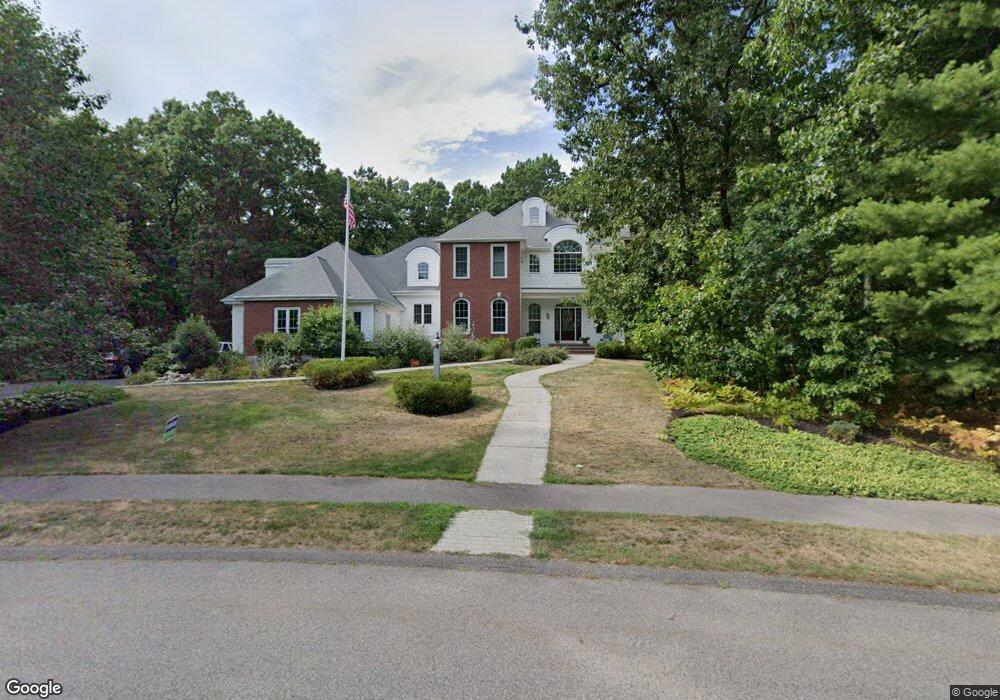
7 Independence Ln Medway, MA 02053
Estimated Value: $1,182,000 - $1,627,000
5
Beds
5
Baths
6,221
Sq Ft
$235/Sq Ft
Est. Value
About This Home
This home is located at 7 Independence Ln, Medway, MA 02053 and is currently estimated at $1,459,702, approximately $234 per square foot. 7 Independence Ln is a home located in Norfolk County with nearby schools including John D. McGovern Elementary School, Burke-Memorial Elementary, and Medway Middle School.
Ownership History
Date
Name
Owned For
Owner Type
Purchase Details
Closed on
Mar 24, 2023
Sold by
Yorkis Paul G and Yorkis Kathleen L
Bought by
Paul G & K L Yorkis Ret
Current Estimated Value
Purchase Details
Closed on
Mar 26, 2012
Sold by
Yorkis Paul G and Yorkis Kathleen L
Bought by
Yorkis Kathleen L
Purchase Details
Closed on
Dec 23, 2004
Sold by
Granite Ests Inc
Bought by
Yorkis Kathleen L and Yorkis Paul G
Create a Home Valuation Report for This Property
The Home Valuation Report is an in-depth analysis detailing your home's value as well as a comparison with similar homes in the area
Home Values in the Area
Average Home Value in this Area
Purchase History
| Date | Buyer | Sale Price | Title Company |
|---|---|---|---|
| Paul G & K L Yorkis Ret | -- | None Available | |
| Yorkis Kathleen L | -- | -- | |
| Yorkis Kathleen L | $77,777 | -- |
Source: Public Records
Tax History
| Year | Tax Paid | Tax Assessment Tax Assessment Total Assessment is a certain percentage of the fair market value that is determined by local assessors to be the total taxable value of land and additions on the property. | Land | Improvement |
|---|---|---|---|---|
| 2025 | $20,759 | $1,456,800 | $329,200 | $1,127,600 |
| 2024 | $20,978 | $1,456,800 | $329,200 | $1,127,600 |
| 2023 | $19,649 | $1,232,700 | $299,600 | $933,100 |
| 2022 | $18,711 | $1,105,200 | $221,600 | $883,600 |
| 2021 | $18,511 | $1,060,200 | $206,800 | $853,400 |
| 2020 | $18,548 | $1,059,900 | $206,800 | $853,100 |
| 2019 | $18,287 | $1,077,600 | $198,300 | $879,300 |
| 2018 | $18,628 | $1,054,800 | $198,300 | $856,500 |
| 2017 | $18,481 | $1,031,300 | $189,900 | $841,400 |
| 2016 | $18,487 | $1,020,800 | $179,400 | $841,400 |
| 2015 | $18,419 | $1,009,800 | $179,400 | $830,400 |
| 2014 | $15,049 | $798,800 | $179,400 | $619,400 |
Source: Public Records
Map
Nearby Homes
- 2 Kingson Ln Unit 2
- 6 Freedom Trail
- 6 Kingson Ln Unit 2
- 10 Franklin St
- 39 West St
- 8 Winthrop St
- 1391 Pond St
- 19 Evergreen St Unit A
- 56 Fisher St
- 4 Linda Ln
- 462 Hartford Ave
- 5 Richardson St
- 3 Nobscott Rd
- 23 Cedar Farms Rd
- 18 Mary Anne Dr
- 22 Granite St
- 79 Lovering St Unit B
- 15 Fox Run Rd
- 3 Thayer Rd
- 44 Arapahoe Rd
- 9 Independence Ln
- 1 Freedom Trail
- 5 Independence Ln
- 31 Highland St
- 31A Highland St
- 12 Independence Ln
- 18 Independence Ln
- 11 Independence Ln
- LOT 3 Freedom Trail
- Lot 18 Freedom Trail
- Lt 5 Freedom Trail
- 33 Highland St
- 3 Independence Ln
- 35 Highland St
- 2 Freedom Trail
- 4 Freedom Trail
- LOT 4 Freedom Trail
- 17 Independence Ln
- 13 Independence Ln
- 15 Independence Ln
Your Personal Tour Guide
Ask me questions while you tour the home.