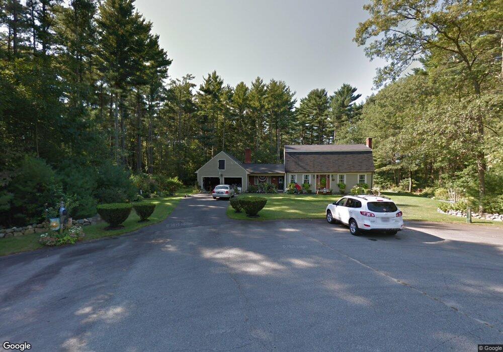
7 Jackie Ln East Freetown, MA 02717
Estimated Value: $622,000 - $711,000
3
Beds
2
Baths
2,214
Sq Ft
$305/Sq Ft
Est. Value
About This Home
This home is located at 7 Jackie Ln, East Freetown, MA 02717 and is currently estimated at $676,032, approximately $305 per square foot. 7 Jackie Ln is a home located in Bristol County with nearby schools including Freetown Elementary School, George R Austin Intermediate School, and Freetown-Lakeville Middle School.
Ownership History
Date
Name
Owned For
Owner Type
Purchase Details
Closed on
Jan 22, 1993
Sold by
Medeiros Eugene J and Medeireos Sheridan
Bought by
Baron Gary A and Mathews Rochelle
Current Estimated Value
Home Financials for this Owner
Home Financials are based on the most recent Mortgage that was taken out on this home.
Original Mortgage
$126,000
Interest Rate
8.15%
Mortgage Type
Purchase Money Mortgage
Create a Home Valuation Report for This Property
The Home Valuation Report is an in-depth analysis detailing your home's value as well as a comparison with similar homes in the area
Home Values in the Area
Average Home Value in this Area
Purchase History
| Date | Buyer | Sale Price | Title Company |
|---|---|---|---|
| Baron Gary A | $158,150 | -- |
Source: Public Records
Mortgage History
| Date | Status | Borrower | Loan Amount |
|---|---|---|---|
| Open | Baron Gary A | $110,000 | |
| Closed | Baron Gary A | $126,000 | |
| Previous Owner | Baron Gary A | $15,000 |
Source: Public Records
Tax History Compared to Growth
Tax History
| Year | Tax Paid | Tax Assessment Tax Assessment Total Assessment is a certain percentage of the fair market value that is determined by local assessors to be the total taxable value of land and additions on the property. | Land | Improvement |
|---|---|---|---|---|
| 2025 | $5,831 | $588,400 | $180,900 | $407,500 |
| 2024 | $5,793 | $555,400 | $170,600 | $384,800 |
| 2023 | $5,647 | $527,300 | $153,700 | $373,600 |
| 2022 | $5,426 | $449,900 | $130,200 | $319,700 |
| 2021 | $5,201 | $409,500 | $118,400 | $291,100 |
| 2020 | $5,161 | $396,400 | $113,900 | $282,500 |
| 2019 | $4,906 | $373,100 | $108,500 | $264,600 |
| 2018 | $4,596 | $345,300 | $108,500 | $236,800 |
| 2017 | $4,452 | $334,200 | $108,500 | $225,700 |
| 2016 | $4,248 | $324,500 | $105,300 | $219,200 |
| 2015 | $4,165 | $322,900 | $105,300 | $217,600 |
| 2014 | $3,912 | $310,200 | $103,200 | $207,000 |
Source: Public Records
Map
Nearby Homes
- 595 Quanapoag Rd
- 599 Quanapoag Rd
- 1599 Braley Rd Unit 68
- 122 Quanapoag Rd
- 1573 Braley Rd Unit 39
- 0 Costa Dr
- 150 Quanapoag Rd
- 13 Luscomb Ln
- 16 Swallow St
- Lot 2/3 Quanapoag Rd
- 1069 Cherokee St
- 4597 Acushnet Ave
- 3 Elaine Ave
- 64 Blaze Rd
- 144 Chace Rd
- 23 Parker Dr
- 210 Heritage Dr
- 34 Poplar Rd
- 145 Heritage Dr
- 26 Blueberry Dr