Estimated Value: $660,290 - $766,000
3
Beds
2
Baths
1,282
Sq Ft
$556/Sq Ft
Est. Value
About This Home
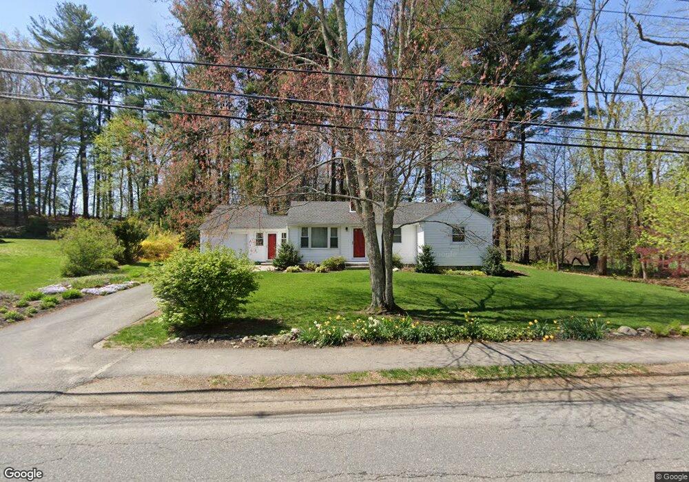
This home is located at 7 Lawsbrook Rd, Acton, MA 01720 and is currently estimated at $713,323, approximately $556 per square foot. 7 Lawsbrook Rd is a home located in Middlesex County with nearby schools including Acton-Boxborough Regional High School and Concord Academy.
Ownership History
Date
Name
Owned For
Owner Type
Purchase Details
Closed on
Sep 29, 2000
Sold by
Maloney John P and Maloney Andra F
Bought by
Camire Richard A and Camire Elizabeth J
Current Estimated Value
Home Financials for this Owner
Home Financials are based on the most recent Mortgage that was taken out on this home.
Original Mortgage
$229,500
Interest Rate
7.94%
Mortgage Type
Purchase Money Mortgage
Purchase Details
Closed on
May 14, 1999
Sold by
Hoodes Pamela A
Bought by
Maloney John P and Maloney Andrea F
Purchase Details
Closed on
Sep 29, 1992
Sold by
Harris Frederic C and Harris Patrice E
Bought by
Freidel Irene C
Purchase Details
Closed on
Apr 11, 1989
Sold by
Bunker Dorothy M
Bought by
Harris Frederic C
Create a Home Valuation Report for This Property
The Home Valuation Report is an in-depth analysis detailing your home's value as well as a comparison with similar homes in the area
Home Values in the Area
Average Home Value in this Area
Purchase History
| Date | Buyer | Sale Price | Title Company |
|---|---|---|---|
| Camire Richard A | $255,000 | -- | |
| Maloney John P | $208,000 | -- | |
| Freidel Irene C | $155,000 | -- | |
| Harris Frederic C | $165,000 | -- |
Source: Public Records
Mortgage History
| Date | Status | Borrower | Loan Amount |
|---|---|---|---|
| Open | Harris Frederic C | $229,500 | |
| Closed | Harris Frederic C | $229,500 |
Source: Public Records
Tax History
| Year | Tax Paid | Tax Assessment Tax Assessment Total Assessment is a certain percentage of the fair market value that is determined by local assessors to be the total taxable value of land and additions on the property. | Land | Improvement |
|---|---|---|---|---|
| 2025 | $10,024 | $584,500 | $268,800 | $315,700 |
| 2024 | $9,500 | $569,900 | $268,800 | $301,100 |
| 2023 | $9,066 | $516,300 | $244,400 | $271,900 |
| 2022 | $9,042 | $464,900 | $212,400 | $252,500 |
| 2021 | $8,685 | $429,300 | $196,700 | $232,600 |
| 2020 | $8,135 | $422,800 | $196,700 | $226,100 |
| 2019 | $7,541 | $389,300 | $196,700 | $192,600 |
| 2018 | $7,002 | $361,300 | $196,700 | $164,600 |
| 2017 | $6,886 | $361,300 | $196,700 | $164,600 |
| 2016 | $6,471 | $336,500 | $196,700 | $139,800 |
| 2015 | $5,944 | $312,000 | $196,700 | $115,300 |
| 2014 | $5,969 | $306,900 | $196,700 | $110,200 |
Source: Public Records
Map
Nearby Homes
- 59 Lexington Dr
- 303 School St
- 65 Summit St
- 245 Oak Hill Cir
- 7 Hillcrest Dr
- 37 Water St
- 27 Water St
- 31 Drummer Rd Unit 31
- 66 Old Stow Rd
- 1732 Main St Unit 205
- 130 Parker St Unit J2
- 1844 Main St Unit 1844
- 20 Westvale Meadows Unit C
- 42 Sunnyside Ln
- 1 Drummer Rd Unit A5
- 116 Conant St
- 1 Vanderbelt Rd
- 95 Concord Rd
- 95 Conant St Unit 320
- 67 Conant St
- 9 Lawsbrook Rd
- 11 Lawsbrook Rd
- 13 Lawsbrook Rd
- 271 School St
- Lot 1 Lexington Place
- 2 Lexington Dr
- 6 Lexington Dr
- 62 Lexington Dr
- 278 School St
- 4 Heritage Rd
- 285 School St
- 6 Heritage Rd
- 282 School St
- 267 School St
- 60 Lexington Dr
- 8 Lexington Dr
- 287 School St
- 8 Heritage Rd
- 61 Lexington Dr
- 280 School St
Your Personal Tour Guide
Ask me questions while you tour the home.