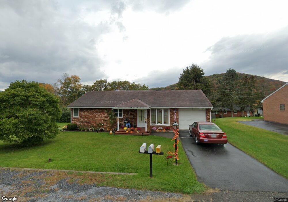
7 Magnolia Dr Lock Haven, PA 17745
Estimated Value: $188,000 - $217,000
3
Beds
1
Bath
1,064
Sq Ft
$191/Sq Ft
Est. Value
About This Home
This home is located at 7 Magnolia Dr, Lock Haven, PA 17745 and is currently estimated at $203,140, approximately $190 per square foot. 7 Magnolia Dr is a home located in Clinton County with nearby schools including Lock Haven Christian School, Lock Haven Catholic Elementary School, and Wordsong Christian School.
Ownership History
Date
Name
Owned For
Owner Type
Purchase Details
Closed on
Mar 18, 2014
Sold by
Yonkin Dennis J
Bought by
Young Pamela J
Current Estimated Value
Home Financials for this Owner
Home Financials are based on the most recent Mortgage that was taken out on this home.
Original Mortgage
$94,000
Outstanding Balance
$71,004
Interest Rate
4.25%
Mortgage Type
New Conventional
Estimated Equity
$132,136
Purchase Details
Closed on
May 25, 2011
Sold by
Williamson Jason M and Williamson Larisha B
Bought by
Yonkin Dennis J
Home Financials for this Owner
Home Financials are based on the most recent Mortgage that was taken out on this home.
Original Mortgage
$116,958
Interest Rate
4.75%
Mortgage Type
FHA
Purchase Details
Closed on
Dec 16, 2003
Bought by
Young Pamela J
Create a Home Valuation Report for This Property
The Home Valuation Report is an in-depth analysis detailing your home's value as well as a comparison with similar homes in the area
Home Values in the Area
Average Home Value in this Area
Purchase History
| Date | Buyer | Sale Price | Title Company |
|---|---|---|---|
| Young Pamela J | $126,000 | None Available | |
| Yonkin Dennis J | $120,000 | None Available | |
| Young Pamela J | -- | -- |
Source: Public Records
Mortgage History
| Date | Status | Borrower | Loan Amount |
|---|---|---|---|
| Open | Young Pamela J | $94,000 | |
| Previous Owner | Yonkin Dennis J | $116,958 |
Source: Public Records
Tax History Compared to Growth
Tax History
| Year | Tax Paid | Tax Assessment Tax Assessment Total Assessment is a certain percentage of the fair market value that is determined by local assessors to be the total taxable value of land and additions on the property. | Land | Improvement |
|---|---|---|---|---|
| 2025 | $2,510 | $102,000 | $20,400 | $81,600 |
| 2024 | $2,458 | $102,000 | $20,400 | $81,600 |
| 2023 | $2,351 | $102,000 | $20,400 | $81,600 |
| 2022 | $2,351 | $102,000 | $20,400 | $81,600 |
| 2021 | $2,366 | $102,000 | $20,400 | $81,600 |
| 2020 | $2,368 | $102,000 | $0 | $0 |
| 2019 | $2,220 | $102,000 | $0 | $0 |
| 2018 | $2,175 | $102,000 | $0 | $0 |
| 2017 | $2,144 | $102,000 | $0 | $0 |
| 2016 | $1,881 | $102,000 | $0 | $0 |
| 2015 | $1,823 | $102,000 | $0 | $0 |
| 2014 | $1,894 | $102,000 | $0 | $0 |
Source: Public Records
Map
Nearby Homes
- 208 Woodward Ave
- 202 Hillside Dr
- PARCEL 036 Coudersport Pike
- 214 Walton Rd
- 16 Woodland Dr
- 1796 Coudersport Pike
- 72 Lockport Heights
- 519 E Main St
- 2030 Coudersport Pike
- 201 E Church St
- 101 E Main St
- PARCEL 45-9 Cedar Crest Dr
- 6 Cedar Crest Dr
- 425 Cider Press Rd
- 55 W Main St
- 145 Oak Hollow Rd
- 4 Grimm Cir
- 310 W Clinton St
- 0 Pennsylvania 120
- 520 W Main St