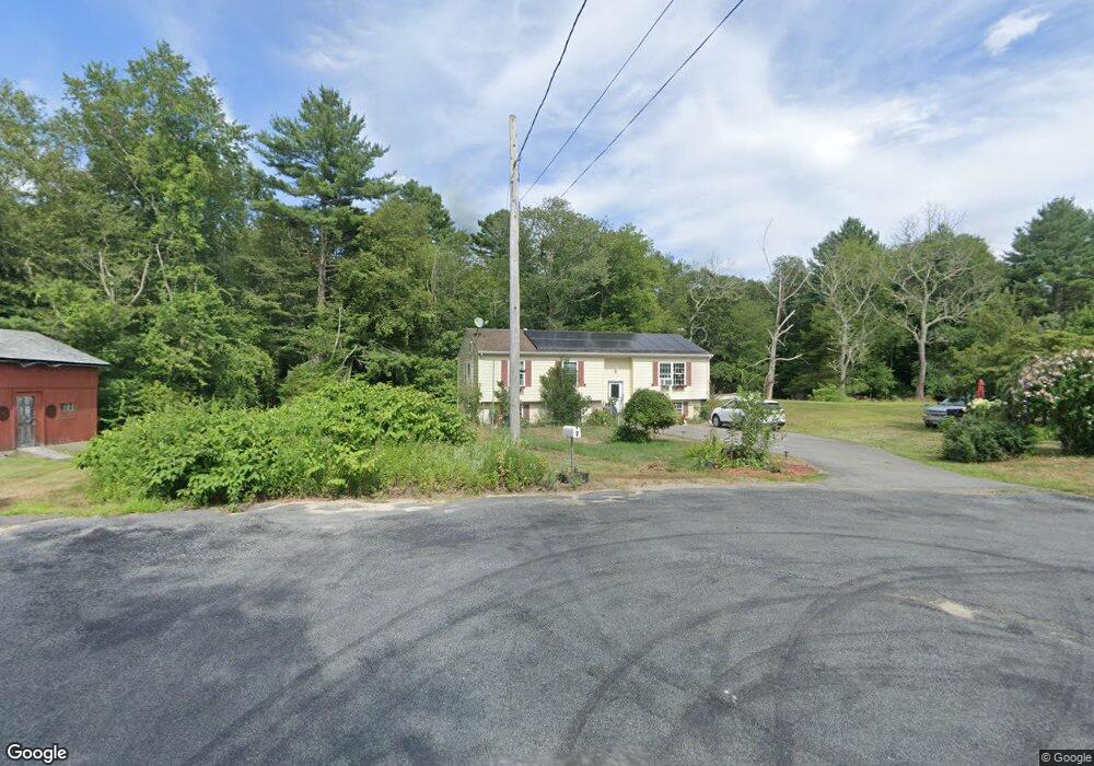
7 Maple Ln Rehoboth, MA 02769
Estimated Value: $423,000 - $597,000
3
Beds
2
Baths
1,136
Sq Ft
$462/Sq Ft
Est. Value
About This Home
This home is located at 7 Maple Ln, Rehoboth, MA 02769 and is currently estimated at $525,014, approximately $462 per square foot. 7 Maple Ln is a home located in Bristol County with nearby schools including Dighton-Rehoboth Regional High School.
Ownership History
Date
Name
Owned For
Owner Type
Purchase Details
Closed on
Sep 1, 2022
Sold by
Jordan Albert
Bought by
Jordan Albert
Current Estimated Value
Purchase Details
Closed on
Jan 21, 2005
Sold by
Jordan Linda L and Derouin James D
Bought by
Bilodeau Joanne and Erickson Craig
Purchase Details
Closed on
Apr 1, 1984
Bought by
Jordan Albert
Create a Home Valuation Report for This Property
The Home Valuation Report is an in-depth analysis detailing your home's value as well as a comparison with similar homes in the area
Home Values in the Area
Average Home Value in this Area
Purchase History
| Date | Buyer | Sale Price | Title Company |
|---|---|---|---|
| Jordan Albert | -- | None Available | |
| Bilodeau Joanne | -- | -- | |
| Jordan Albert | -- | -- |
Source: Public Records
Mortgage History
| Date | Status | Borrower | Loan Amount |
|---|---|---|---|
| Previous Owner | Jordan Albert | $16,000 | |
| Previous Owner | Jordan Albert | $110,000 |
Source: Public Records
Tax History
| Year | Tax Paid | Tax Assessment Tax Assessment Total Assessment is a certain percentage of the fair market value that is determined by local assessors to be the total taxable value of land and additions on the property. | Land | Improvement |
|---|---|---|---|---|
| 2025 | $44 | $393,600 | $190,800 | $202,800 |
| 2024 | $4,643 | $408,700 | $190,800 | $217,900 |
| 2023 | $4,406 | $380,500 | $186,800 | $193,700 |
| 2022 | $4,241 | $334,700 | $178,400 | $156,300 |
| 2021 | $54,942 | $310,700 | $162,100 | $148,600 |
| 2020 | $3,817 | $290,900 | $162,100 | $128,800 |
| 2018 | $4,867 | $273,900 | $154,300 | $119,600 |
| 2017 | $3,268 | $260,200 | $154,300 | $105,900 |
| 2016 | $3,198 | $263,200 | $154,300 | $108,900 |
| 2015 | $3,069 | $249,300 | $147,100 | $102,200 |
| 2014 | $2,877 | $231,300 | $139,900 | $91,400 |
Source: Public Records
Map
Nearby Homes
- 0 Horton St Unit 73333337
- 24 New St
- 133 Winthrop St
- 2713 Horton St
- 23 Bay State Rd
- 248 County
- 349 Anawan St
- 0 Winthrop St Unit 73180872
- 10 Muriel Way
- 145 Winthrop St
- 139 Winthrop St
- 257 Anawan St
- 321 Winthrop St
- 19 Cedar St Unit 21
- 2188 Cedar St
- 185 Moulton St
- 1 Clubhouse Way
- 2201 Wheeler St
- 8 Linden Ln
- 8 Linden Ln
- 11 Maple Ln
- 10 Maple Ln
- 16 Maple Ln
- 15 Maple Ln
- 21 Maple Ln
- 22 Maple Ln
- 25 Maple Ln
- 26 Maple Ln
- 30 Maple Ln
- 29 Maple Ln
- 34 Maple Ln
- 41 Maple Ln
- 40 Maple Ln
- 45 Maple Ln
- 51 Maple Ln
- 0 Maple Lane L-17a Unit 50491783
- 0 Maple Lane L-M41 P-17d Unit 50491784
- 0 Maple Lane L-7e Unit 50491781
- 48 Maple Ln
- 52 Maple Ln
Your Personal Tour Guide
Ask me questions while you tour the home.