
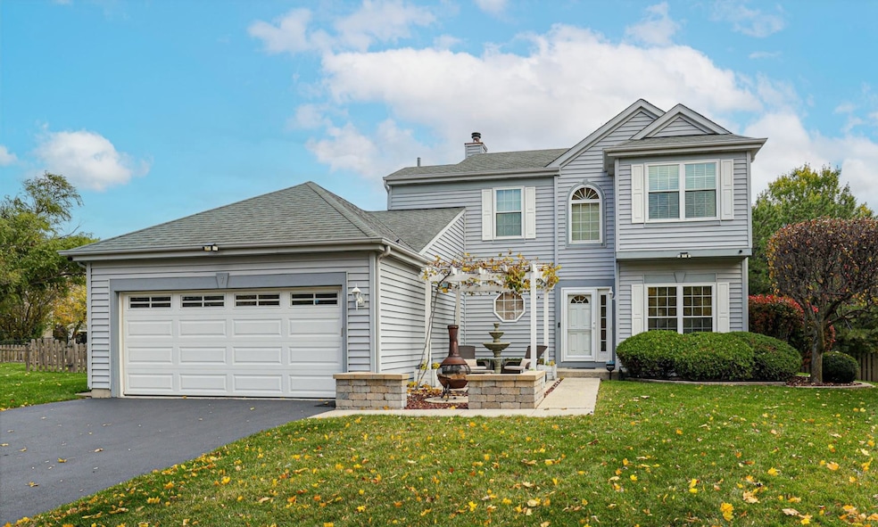
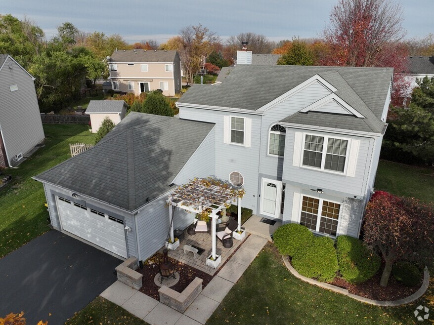

7 Michael Ct Lake In the Hills, IL 60156
Estimated payment $2,643/month
Total Views
15,112
3
Beds
2.5
Baths
1,502
Sq Ft
$253
Price per Sq Ft
Highlights
- Recreation Room
- Wood Flooring
- Stainless Steel Appliances
- Harry D Jacobs High School Rated A-
- Den
- 2-minute walk to Stoneybrook Park
About This Home
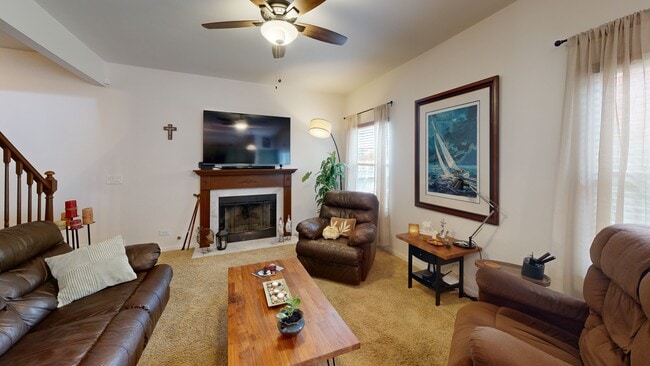
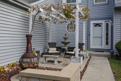
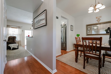
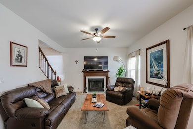
Welcome to 7 Michael Court, a captivating 3-bedroom, 2.5-bath residence, ideally situated on a serene cul-de-sac in the desirable Stoney Brooke subdivision. This meticulously maintained property seamlessly blends comfort and elegance. Step inside to discover an inviting, open-concept floor plan, featuring gleaming hard flooring throughout the kitchen and dining area. The gourmet kitchen, the heart of the home, is accentuated by luxurious Italian marble countertops, perfect for culinary enthusiasts and entertaining alike. Extend your living space downstairs into the fully finished basement, offering versatility as a family room, a dedicated home office, home gym, or a recreational haven. The outdoor living areas are an entertainer's delight. The private backyard oasis features a 12x20 Kayak above-ground pool with an expansive aluminum deck, enveloped by mature trees for ultimate seclusion. The charming front courtyard presents a picturesque setting, complete with a vine-draped pergola, a cozy fire pit, and a tranquil water fountain, offering a perfect venue for quiet relaxation. Peace of mind comes standard with numerous significant updates, including an updated roof, siding, windows, patio door, garage door, front door, asphalt driveway, HVAC system, water heater, and water softener. Oversized garage has a heater and bump-out extending to almost an additional space. This move-in ready home is a rare find, combining modern amenities, exquisite outdoor spaces, and a prime location near local parks, shopping centers, and top-tier schools.
Home Details
Home Type
- Single Family
Est. Annual Taxes
- $7,685
Year Built
- Built in 1994
Lot Details
- Lot Dimensions are 43x111x49x49x26x110
Parking
- 2 Car Garage
Interior Spaces
- 1,502 Sq Ft Home
- 2-Story Property
- Family Room with Fireplace
- Living Room
- Dining Room
- Den
- Recreation Room
- Basement Fills Entire Space Under The House
Kitchen
- Range
- Microwave
- Dishwasher
- Stainless Steel Appliances
Flooring
- Wood
- Carpet
Bedrooms and Bathrooms
- 3 Bedrooms
- 3 Potential Bedrooms
Laundry
- Laundry Room
- Dryer
- Washer
Schools
- Lake In The Hills Elementary Sch
- Westfield Community Middle School
- H D Jacobs High School
Utilities
- Forced Air Heating and Cooling System
- Heating System Uses Natural Gas
- Water Softener
Community Details
- Stoney Brooke Subdivision, Arlington Floorplan
3D Interior and Exterior Tours
Floorplans
Map
Create a Home Valuation Report for This Property
The Home Valuation Report is an in-depth analysis detailing your home's value as well as a comparison with similar homes in the area
Home Values in the Area
Average Home Value in this Area
Tax History
| Year | Tax Paid | Tax Assessment Tax Assessment Total Assessment is a certain percentage of the fair market value that is determined by local assessors to be the total taxable value of land and additions on the property. | Land | Improvement |
|---|---|---|---|---|
| 2024 | $7,685 | $104,049 | $23,419 | $80,630 |
| 2023 | $7,306 | $93,058 | $20,945 | $72,113 |
| 2022 | $6,807 | $82,876 | $22,290 | $60,586 |
| 2021 | $6,540 | $77,209 | $20,766 | $56,443 |
| 2020 | $6,376 | $74,476 | $20,031 | $54,445 |
| 2019 | $6,244 | $71,282 | $19,172 | $52,110 |
| 2018 | $5,968 | $65,850 | $17,711 | $48,139 |
| 2017 | $5,843 | $62,035 | $16,685 | $45,350 |
| 2016 | $5,747 | $58,183 | $15,649 | $42,534 |
| 2013 | -- | $53,958 | $14,598 | $39,360 |
Source: Public Records
Property History
| Date | Event | Price | List to Sale | Price per Sq Ft |
|---|---|---|---|---|
| 11/14/2025 11/14/25 | Pending | -- | -- | -- |
| 11/06/2025 11/06/25 | For Sale | $380,000 | -- | $253 / Sq Ft |
Source: Midwest Real Estate Data (MRED)
Purchase History
| Date | Type | Sale Price | Title Company |
|---|---|---|---|
| Warranty Deed | -- | None Available | |
| Warranty Deed | $217,750 | Fatic | |
| Warranty Deed | $154,000 | Chicago Title |
Source: Public Records
Mortgage History
| Date | Status | Loan Amount | Loan Type |
|---|---|---|---|
| Previous Owner | $214,300 | FHA | |
| Previous Owner | $145,800 | No Value Available |
Source: Public Records
About the Listing Agent
Always having a passion for architecture and a desire to meet new people, entering the real estate business was a natural fit. In 1994, I began developing condominiums on Chicago's North Side having recently graduated with honors from Loyola University. I then formed North Shore Realty Group in 1999 until merging talent with Keller Williams in 2016 where I remain today as a Broker. Although the market has evolved and I have evolved with it, I've always subscribed to one core philosophy...treat
Joseph's Other Listings
Source: Midwest Real Estate Data (MRED)
MLS Number: 12510784
APN: 19-21-455-022
Disclaimer: Certain information contained herein is derived from information provided by parties other than Homes.com. All information provided is deemed reliable, but is not guaranteed to be accurate and should be independently verified.
![]() Based on information submitted to the MLS GRID. All data is obtained from various sources and may not have been verified by broker or MLS GRID. Supplied Open House Information is subject to change without notice. All information should be independently reviewed and verified for accuracy. Properties may or may not be listed by the office/agent presenting the information. Some IDX listings have been excluded from this website.
Based on information submitted to the MLS GRID. All data is obtained from various sources and may not have been verified by broker or MLS GRID. Supplied Open House Information is subject to change without notice. All information should be independently reviewed and verified for accuracy. Properties may or may not be listed by the office/agent presenting the information. Some IDX listings have been excluded from this website.
The Digital Millennium Copyright Act of 1998, 17 U.S.C. § 512 (the “DMCA”) provides recourse for copyright owners who believe that material appearing on the Internet infringes their rights under U.S. copyright law. If you believe in good faith that any content or material made available in connection with our website or services infringes your copyright, you (or your agent) may send us a notice requesting that the content or material be removed, or access to it blocked.
Notices must be sent in writing by email to DMCAnotice@MLSGrid.com.
The DMCA requires that your notice of alleged copyright infringement include the following information:
(1) description of the copyrighted work that is the subject of claimed infringement;
(2) description of the alleged infringing content and information sufficient to permit us to locate the content;
(3) contact information for you, including your address, telephone number and email address;
(4) a statement by you that you have a good faith belief that the content in the manner complained of is not authorized by the copyright owner, or its agent, or by the operation of any law;
(5) a statement by you, signed under penalty of perjury, that the information in the notification is accurate and that you have the authority to enforce the copyrights that are claimed to be infringed; and
(6) a physical or electronic signature of the copyright owner or a person authorized to act on the copyright owner’s behalf. Failure to include all of the above information may result in the delay of the processing of your complaint.
Nearby Homes
- 618 Grace Dr
- 832 Brandt Dr
- 937 Mesa Dr
- 900 Windstone Ct
- 992 Mcphee Dr
- 1049 Horizon Ridge
- 809 Menominee Dr
- 807 Menominee Dr
- 541 Blackhawk Dr
- LOT 3 Blackhawk Dr
- 909 Roger St
- 1019 Maple St
- 16 Brian Ct
- 20 Echo Hill
- lot 021 Route 31 Hwy
- 266 Grandview Ct
- 10401 Kenilworth Ave
- 1114 Ash St
- Lots 10 & 11 Ramble Rd
- 10280 Kenilworth Ave