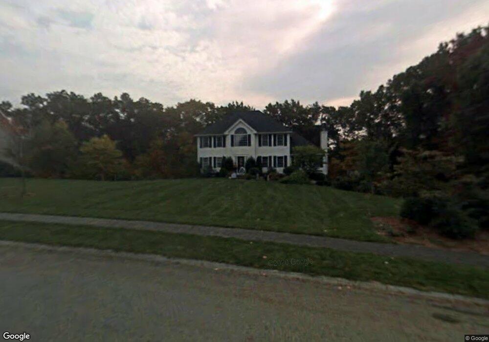
7 Morrison Ln Westford, MA 01886
Estimated Value: $1,102,000 - $1,225,000
4
Beds
3
Baths
2,508
Sq Ft
$468/Sq Ft
Est. Value
About This Home
This home is located at 7 Morrison Ln, Westford, MA 01886 and is currently estimated at $1,173,424, approximately $467 per square foot. 7 Morrison Ln is a home located in Middlesex County with nearby schools including Rita E. Miller Elementary School, Day Elementary School, and Stony Brook School.
Ownership History
Date
Name
Owned For
Owner Type
Purchase Details
Closed on
Aug 19, 2011
Sold by
Coleman Russell T and Coleman Cindy S
Bought by
Hu Qingyong Z and Zhang Xueying H
Current Estimated Value
Home Financials for this Owner
Home Financials are based on the most recent Mortgage that was taken out on this home.
Original Mortgage
$463,500
Outstanding Balance
$312,264
Interest Rate
4%
Mortgage Type
Purchase Money Mortgage
Estimated Equity
$861,160
Purchase Details
Closed on
May 26, 2000
Sold by
Greystone Llc
Bought by
Coleman Russell T and Coleman Cindy S
Create a Home Valuation Report for This Property
The Home Valuation Report is an in-depth analysis detailing your home's value as well as a comparison with similar homes in the area
Home Values in the Area
Average Home Value in this Area
Purchase History
| Date | Buyer | Sale Price | Title Company |
|---|---|---|---|
| Hu Qingyong Z | $618,000 | -- | |
| Coleman Russell T | $371,018 | -- |
Source: Public Records
Mortgage History
| Date | Status | Borrower | Loan Amount |
|---|---|---|---|
| Open | Hu Qingyong Z | $463,500 | |
| Previous Owner | Coleman Russell T | $48,000 | |
| Previous Owner | Coleman Russell T | $384,000 | |
| Previous Owner | Coleman Russell T | $10,000 |
Source: Public Records
Tax History Compared to Growth
Tax History
| Year | Tax Paid | Tax Assessment Tax Assessment Total Assessment is a certain percentage of the fair market value that is determined by local assessors to be the total taxable value of land and additions on the property. | Land | Improvement |
|---|---|---|---|---|
| 2025 | $13,972 | $1,014,700 | $347,900 | $666,800 |
| 2024 | $13,972 | $1,014,700 | $347,900 | $666,800 |
| 2023 | $13,396 | $907,600 | $331,500 | $576,100 |
| 2022 | $13,742 | $852,500 | $274,400 | $578,100 |
| 2021 | $12,229 | $734,900 | $274,400 | $460,500 |
| 2020 | $12,025 | $736,400 | $274,400 | $462,000 |
| 2019 | $11,046 | $667,000 | $274,400 | $392,600 |
| 2018 | $10,792 | $667,000 | $274,400 | $392,600 |
| 2017 | $10,171 | $619,800 | $274,400 | $345,400 |
| 2016 | $9,919 | $608,500 | $262,000 | $346,500 |
| 2015 | $9,739 | $599,700 | $253,300 | $346,400 |
| 2014 | $9,708 | $584,800 | $253,700 | $331,100 |
Source: Public Records
Map
Nearby Homes
- 6 Caldwell Dr
- 12 Kestrel Ln Unit 7
- 20 Highland Rd
- 22 Highland Rd
- 0 Dunstable Rd
- 15 Stone Ridge Rd
- 19 Sandstone Rd
- 216 Westford Rd
- 31 Sandstone Rd
- 26 N Hill Rd
- D11 Scotty Hollow Dr Unit D
- 427 Groton Rd
- 10 Gassett Rd
- 48 Mission Rd
- 30 Lake Shore Dr N
- 44 Shakespeare St
- 2 Alder Point Unit 2
- 10 Dickens Ln
- 5 Mission Rd Unit 203
- 55 Lawson Rd