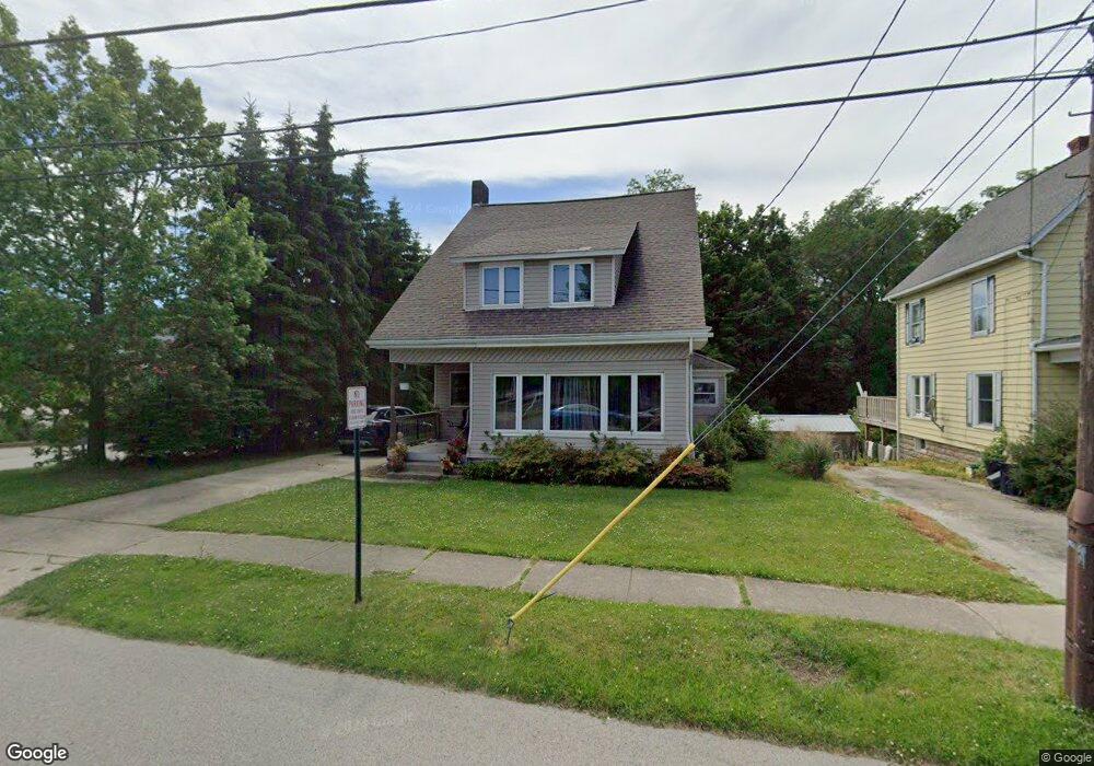
7 N Mill St North East, PA 16428
Estimated Value: $197,002 - $232,000
3
Beds
2
Baths
1,516
Sq Ft
$141/Sq Ft
Est. Value
About This Home
This home is located at 7 N Mill St, North East, PA 16428 and is currently estimated at $213,751, approximately $140 per square foot. 7 N Mill St is a home located in Erie County with nearby schools including Earle C. Davis Primary School, North East Intermediate Elementary School, and North East Middle School.
Ownership History
Date
Name
Owned For
Owner Type
Purchase Details
Closed on
Aug 31, 2006
Sold by
Morrison Robert H and Morrison Jennine
Bought by
Evans David R
Current Estimated Value
Home Financials for this Owner
Home Financials are based on the most recent Mortgage that was taken out on this home.
Original Mortgage
$27,600
Interest Rate
6.44%
Mortgage Type
Balloon
Purchase Details
Closed on
Nov 14, 2003
Sold by
Eastlake Development Corp
Bought by
Morrison Robert H and Rosseter William K
Purchase Details
Closed on
Aug 11, 2003
Sold by
Fitzgerald Thomas M
Bought by
Eastlake Development Corp
Purchase Details
Closed on
Nov 17, 1999
Sold by
Carr Emma M and Swift Tad
Bought by
Swift Emma M
Create a Home Valuation Report for This Property
The Home Valuation Report is an in-depth analysis detailing your home's value as well as a comparison with similar homes in the area
Home Values in the Area
Average Home Value in this Area
Purchase History
| Date | Buyer | Sale Price | Title Company |
|---|---|---|---|
| Evans David R | $138,000 | None Available | |
| Morrison Robert H | $35,000 | -- | |
| Eastlake Development Corp | $25,700 | -- | |
| Swift Emma M | -- | -- |
Source: Public Records
Mortgage History
| Date | Status | Borrower | Loan Amount |
|---|---|---|---|
| Closed | Evans David R | $27,600 | |
| Open | Evans David R | $110,400 |
Source: Public Records
Tax History Compared to Growth
Tax History
| Year | Tax Paid | Tax Assessment Tax Assessment Total Assessment is a certain percentage of the fair market value that is determined by local assessors to be the total taxable value of land and additions on the property. | Land | Improvement |
|---|---|---|---|---|
| 2025 | $2,851 | $102,600 | $29,500 | $73,100 |
| 2024 | $2,763 | $102,600 | $29,500 | $73,100 |
| 2023 | $2,638 | $102,600 | $29,500 | $73,100 |
| 2022 | $2,581 | $102,600 | $29,500 | $73,100 |
| 2021 | $2,554 | $102,600 | $29,500 | $73,100 |
| 2020 | $2,528 | $102,600 | $29,500 | $73,100 |
| 2019 | $2,528 | $102,600 | $29,500 | $73,100 |
| 2018 | $2,483 | $102,600 | $29,500 | $73,100 |
| 2017 | $2,456 | $102,600 | $29,500 | $73,100 |
| 2016 | $2,898 | $102,600 | $29,500 | $73,100 |
| 2015 | $2,873 | $102,600 | $29,500 | $73,100 |
| 2014 | $1,477 | $102,600 | $29,500 | $73,100 |
Source: Public Records
Map
Nearby Homes
- 94 Gibson St
- 55 S Pearl St
- 48 N Pearl St
- 10644 W Main Rd Unit 60
- 10644 W Main Rd Unit 170
- 10644 W Main Rd Unit 155C
- 10644 W Main St Unit 155D
- 51 E Main St
- 2085 Cemetery Rd
- 2165 Freeport Rd
- 0 Ackerman Ln
- 74 Smedley St
- 3101 Cemetery Rd
- 1648 Freeport Rd
- 128 Grahamville St
- 131 Wellington St
- 107 Jefferson St
- 126 Pine Tree Ln
- 4709 Cedar Dr
- 0 Concord Dr