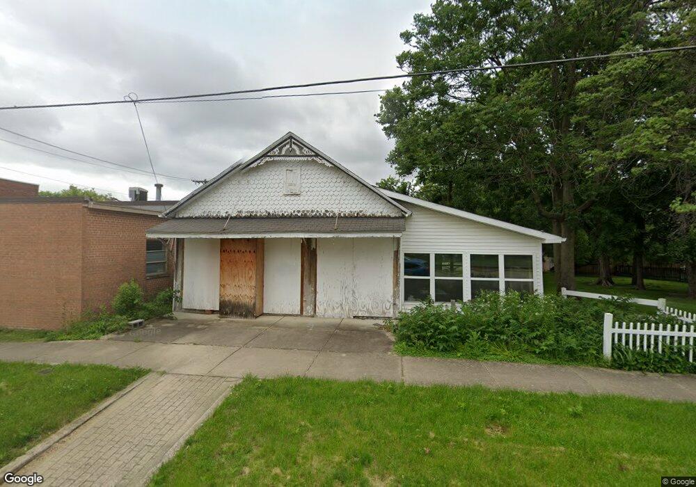
7 N Walnut St Oakland, IL 61943
Estimated Value: $117,882
3
Beds
2
Baths
1,427
Sq Ft
$83/Sq Ft
Est. Value
About This Home
This home is located at 7 N Walnut St, Oakland, IL 61943 and is currently estimated at $117,882, approximately $82 per square foot. 7 N Walnut St is a home located in Coles County with nearby schools including Lake Crest Elementary School and Oakland High School.
Ownership History
Date
Name
Owned For
Owner Type
Purchase Details
Closed on
May 11, 2021
Sold by
End Of The Road Llc
Bought by
Christenson Diane
Current Estimated Value
Purchase Details
Closed on
Dec 30, 2020
Sold by
11T Il Llc
Bought by
End Of The Road Llc
Purchase Details
Closed on
Mar 11, 2019
Sold by
Guardian Tax Il Llc
Bought by
11T Il Llc
Purchase Details
Closed on
Dec 26, 2018
Sold by
Coles County Clerk
Bought by
Guardian Tax Il Llc
Purchase Details
Closed on
Dec 2, 2011
Sold by
Coon Paul E and Coon Mary Jane
Bought by
Thomas Lee Allen and Thomas Monica D
Create a Home Valuation Report for This Property
The Home Valuation Report is an in-depth analysis detailing your home's value as well as a comparison with similar homes in the area
Home Values in the Area
Average Home Value in this Area
Purchase History
| Date | Buyer | Sale Price | Title Company |
|---|---|---|---|
| Christenson Diane | $3,500 | None Available | |
| End Of The Road Llc | -- | Attorney | |
| 11T Il Llc | -- | None Available | |
| Guardian Tax Il Llc | -- | None Available | |
| Thomas Lee Allen | $55,000 | None Available |
Source: Public Records
Tax History Compared to Growth
Tax History
| Year | Tax Paid | Tax Assessment Tax Assessment Total Assessment is a certain percentage of the fair market value that is determined by local assessors to be the total taxable value of land and additions on the property. | Land | Improvement |
|---|---|---|---|---|
| 2024 | $875 | $10,131 | $953 | $9,178 |
| 2023 | $873 | $10,131 | $953 | $9,178 |
| 2022 | $944 | $10,188 | $1,054 | $9,134 |
| 2021 | $924 | $9,208 | $953 | $8,255 |
| 2020 | $936 | $9,540 | $987 | $8,553 |
| 2019 | $1,851 | $18,167 | $2,357 | $15,810 |
| 2018 | $1,849 | $18,167 | $2,357 | $15,810 |
| 2017 | $1,909 | $18,167 | $2,357 | $15,810 |
| 2016 | $1,953 | $18,167 | $2,357 | $15,810 |
| 2015 | $1,053 | $18,167 | $2,357 | $15,810 |
| 2014 | $1,053 | $18,167 | $2,357 | $15,810 |
| 2013 | $1,053 | $18,167 | $2,357 | $15,810 |
Source: Public Records
Map
Nearby Homes
- 512 Norton Dr
- 100 N Reel St
- 312 Ashmore Rd
- 215 Silver St
- 509 Lakeshore Dr
- 22518 State Highway 133
- 0 E Co Road 1550 N
- County Road 1550 N
- 0 County Road 2300 Rd E Unit 24630606
- 0 County Road 2300 Rd E Unit RMAPA1260552
- 212 Michigan St
- 206 S Boyer Ave
- 18428 E Co Road 1500 N
- 20315 Airtight Rd
- 12 E Walnut St
- 6 S Oakland Rd
- 210 Buena Vista St
- 2445 E County Road 875 N
- 137 E Buena Vista St
- 303 S Front St
- 23 N Walnut St
- 111 W Main St
- 121 W Main St
- 116 W Montgomery St
- 115 W Montgomery St
- 123 W Main St
- 116 W Main St
- 119 W Montgomery St
- 124 W Montgomery St
- 120 W Main St
- 123 W Montgomery St
- 116 W Washington St
- 101 N Walnut St
- 109 N Walnut St
- 109 N Walnut St
- 120 W Washington St
- 131 W Main St
- 126 W Main St
- 111 N Walnut St
- 124 W Washington St