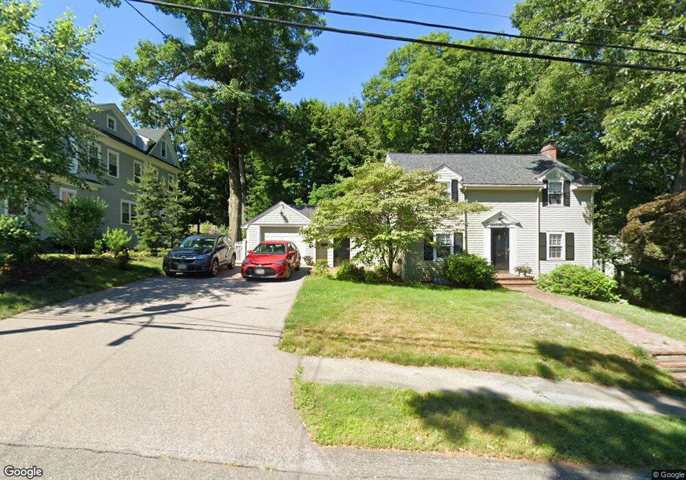
7 Parker Rd Needham Heights, MA 02494
Estimated Value: $1,279,000 - $1,362,163
3
Beds
3
Baths
1,098
Sq Ft
$1,200/Sq Ft
Est. Value
About This Home
This home is located at 7 Parker Rd, Needham Heights, MA 02494 and is currently estimated at $1,317,541, approximately $1,199 per square foot. 7 Parker Rd is a home located in Norfolk County with nearby schools including Mitchell Elementary School, High Rock Middle School, and Pollard Middle School.
Ownership History
Date
Name
Owned For
Owner Type
Purchase Details
Closed on
Jun 30, 2000
Sold by
Simms James A and Simms Nancy G
Bought by
Mccormack Peter S and Mccormack Ruth R
Current Estimated Value
Home Financials for this Owner
Home Financials are based on the most recent Mortgage that was taken out on this home.
Original Mortgage
$340,000
Outstanding Balance
$124,763
Interest Rate
8.59%
Mortgage Type
Purchase Money Mortgage
Estimated Equity
$1,192,778
Purchase Details
Closed on
Jun 8, 1990
Sold by
Magid Herbert
Bought by
Simms James A
Home Financials for this Owner
Home Financials are based on the most recent Mortgage that was taken out on this home.
Original Mortgage
$236,000
Interest Rate
10.39%
Mortgage Type
Purchase Money Mortgage
Create a Home Valuation Report for This Property
The Home Valuation Report is an in-depth analysis detailing your home's value as well as a comparison with similar homes in the area
Home Values in the Area
Average Home Value in this Area
Purchase History
| Date | Buyer | Sale Price | Title Company |
|---|---|---|---|
| Mccormack Peter S | $520,000 | -- | |
| Simms James A | $295,000 | -- | |
| Simms James A | $295,000 | -- |
Source: Public Records
Mortgage History
| Date | Status | Borrower | Loan Amount |
|---|---|---|---|
| Open | Simms James A | $340,000 | |
| Previous Owner | Simms James A | $236,000 |
Source: Public Records
Tax History
| Year | Tax Paid | Tax Assessment Tax Assessment Total Assessment is a certain percentage of the fair market value that is determined by local assessors to be the total taxable value of land and additions on the property. | Land | Improvement |
|---|---|---|---|---|
| 2025 | $11,502 | $1,085,100 | $772,800 | $312,300 |
| 2024 | $10,965 | $875,800 | $552,000 | $323,800 |
| 2023 | $11,072 | $849,100 | $552,000 | $297,100 |
| 2022 | $10,343 | $773,600 | $484,200 | $289,400 |
| 2021 | $10,080 | $773,600 | $484,200 | $289,400 |
| 2020 | $9,561 | $765,500 | $484,100 | $281,400 |
| 2019 | $8,912 | $719,300 | $440,100 | $279,200 |
| 2018 | $8,545 | $719,300 | $440,100 | $279,200 |
| 2017 | $8,140 | $684,600 | $440,100 | $244,500 |
| 2016 | $7,900 | $684,600 | $440,100 | $244,500 |
| 2015 | $7,729 | $684,600 | $440,100 | $244,500 |
| 2014 | $7,464 | $641,200 | $400,100 | $241,100 |
Source: Public Records
Map
Nearby Homes
- 143 Hunting Rd
- 100 Woodbine Cir
- 108 Woodbine Cir
- 5 Hazel Ln
- 40 High St
- 28 Mercer Rd
- 5 Sachem Rd
- 7 West St
- 17 Lindbergh Ave
- 510 Webster St
- 132 Hillside Ave
- 134 Hillside Ave Unit 134
- 62 Evelyn Rd
- 140 Hillside Ave
- 140 Hillside Ave Unit a
- 58 Morton St
- 379 Hunnewell St Unit 379
- 385 Hillside Ave
- 385 Hillside Ave Unit 385
- 3 Crescent Rd
- 15 Parker Rd
- 161 Greendale Ave
- 8 Parker Rd
- 175 Greendale Ave
- 23 Parker Rd
- 155 Greendale Ave
- 14 Parker Rd
- 118 Concord St
- 16 Cimino Rd
- 22 Parker Rd
- 183 Greendale Ave
- 170 Greendale Ave
- 24 Cimino Rd
- 164 Greendale Ave
- 29 Parker Rd
- 151 Greendale Ave
- 176 Greendale Ave
- 28 Parker Rd
- 156 Greendale Ave
- 30 Cimino Rd
Your Personal Tour Guide
Ask me questions while you tour the home.