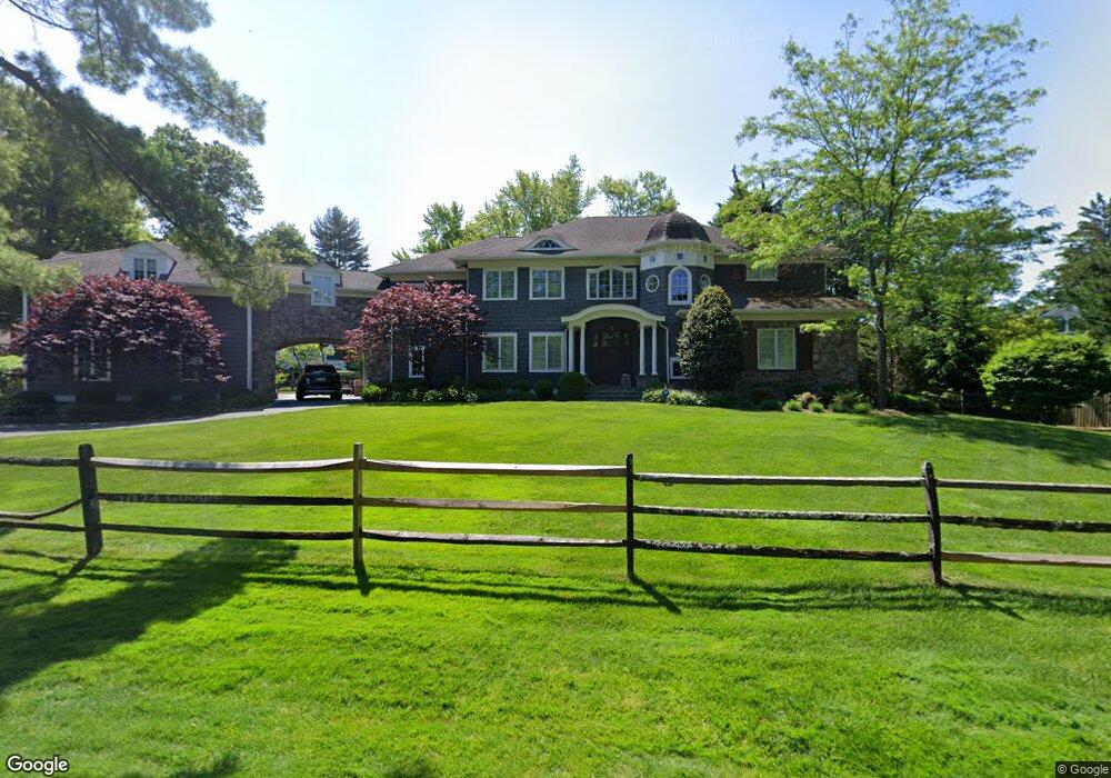
7 Pine Ct New Providence, NJ 07974
Estimated Value: $1,575,000 - $2,534,000
Studio
--
Bath
5,084
Sq Ft
$405/Sq Ft
Est. Value
About This Home
This home is located at 7 Pine Ct, New Providence, NJ 07974 and is currently estimated at $2,057,325, approximately $404 per square foot. 7 Pine Ct is a home located in Union County with nearby schools including New Providence High School, The Academy of Our Lady of Peace, and Oak Knoll School of the Holy Child.
Ownership History
Date
Name
Owned For
Owner Type
Purchase Details
Closed on
Jan 11, 2013
Sold by
Bisaccia Christopher M and Bisaccia Nicole L
Bought by
Bisaccia Nicole L
Current Estimated Value
Purchase Details
Closed on
Jan 7, 2013
Sold by
Bisaccia Christopher M and Bisaccia Nicole L
Bought by
Bisaccia Nicole L
Purchase Details
Closed on
Mar 18, 2008
Sold by
Muntz Jerry E and Muntz Susan T
Bought by
Bisaccia Christopher M and Bisaccia Nicole L
Home Financials for this Owner
Home Financials are based on the most recent Mortgage that was taken out on this home.
Original Mortgage
$775,250
Interest Rate
5.75%
Mortgage Type
Purchase Money Mortgage
Create a Home Valuation Report for This Property
The Home Valuation Report is an in-depth analysis detailing your home's value as well as a comparison with similar homes in the area
Home Values in the Area
Average Home Value in this Area
Purchase History
| Date | Buyer | Sale Price | Title Company |
|---|---|---|---|
| Bisaccia Nicole L | -- | None Available | |
| Bisaccia Nicole L | -- | None Available | |
| Bisaccia Christopher M | $975,250 | None Available |
Source: Public Records
Mortgage History
| Date | Status | Borrower | Loan Amount |
|---|---|---|---|
| Previous Owner | Bisaccia Christopher M | $775,250 |
Source: Public Records
Tax History
| Year | Tax Paid | Tax Assessment Tax Assessment Total Assessment is a certain percentage of the fair market value that is determined by local assessors to be the total taxable value of land and additions on the property. | Land | Improvement |
|---|---|---|---|---|
| 2025 | $43,387 | $840,500 | $194,300 | $646,200 |
| 2024 | $42,084 | $840,500 | $194,300 | $646,200 |
| 2023 | $42,084 | $840,500 | $194,300 | $646,200 |
| 2022 | $41,504 | $840,500 | $194,300 | $646,200 |
| 2021 | $41,201 | $840,500 | $194,300 | $646,200 |
| 2020 | $41,185 | $840,500 | $194,300 | $646,200 |
| 2019 | $40,932 | $840,500 | $194,300 | $646,200 |
| 2018 | $38,968 | $804,300 | $194,300 | $610,000 |
| 2017 | $38,333 | $804,300 | $194,300 | $610,000 |
| 2016 | $37,794 | $804,300 | $194,300 | $610,000 |
| 2015 | $37,271 | $804,300 | $194,300 | $610,000 |
| 2014 | $36,708 | $804,300 | $194,300 | $610,000 |
Source: Public Records
Map
Nearby Homes
- 47 Clinton Ave
- 297 Elkwood Ave
- 50 Livingston Ave
- 852 Springfield Ave
- 100 Commonwealth Ave
- 107 Pleasantview Ave
- 77 Commonwealth Ave
- 26 E 3rd St
- 240 Riveredge Dr
- 199 Hickson Dr
- 65 Division Ave
- 10C Heritage Dr Unit C
- 5G Terrace Dr
- 19I Heritage Dr Unit I
- 19C Heritage Dr
- 2F Terrace Dr Unit F
- 157 Grant Ave
- 2H Heritage Dr Unit H
- 20C Heritage Dr Unit C
- 32 Charnwood Rd
Your Personal Tour Guide
Ask me questions while you tour the home.