Estimated Value: $631,000 - $709,000
2
Beds
2
Baths
1,992
Sq Ft
$334/Sq Ft
Est. Value
About This Home
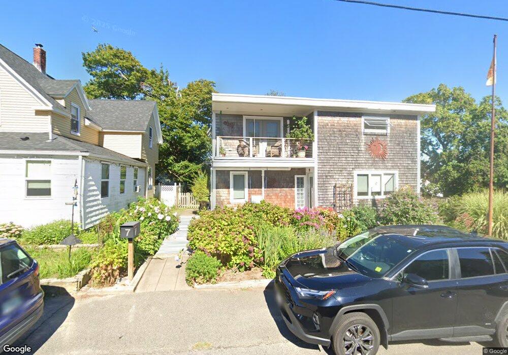
This home is located at 7 Standish Rd, Hull, MA 02045 and is currently estimated at $664,935, approximately $333 per square foot. 7 Standish Rd is a home located in Plymouth County with nearby schools including Lillian M. Jacobs Elementary School, Memorial Middle School, and Hull High School.
Ownership History
Date
Name
Owned For
Owner Type
Purchase Details
Closed on
Jul 6, 2011
Sold by
Munro David M
Bought by
Munro Draper Ft and Munro
Current Estimated Value
Home Financials for this Owner
Home Financials are based on the most recent Mortgage that was taken out on this home.
Original Mortgage
$100,000
Outstanding Balance
$69,293
Interest Rate
4.74%
Mortgage Type
Unknown
Estimated Equity
$595,642
Purchase Details
Closed on
Apr 30, 1990
Sold by
Ketchem John V
Bought by
Munro David M
Create a Home Valuation Report for This Property
The Home Valuation Report is an in-depth analysis detailing your home's value as well as a comparison with similar homes in the area
Purchase History
| Date | Buyer | Sale Price | Title Company |
|---|---|---|---|
| Munro Draper Ft | -- | -- | |
| Munro David M | $127,500 | -- | |
| Munro David M | $127,500 | -- |
Source: Public Records
Mortgage History
| Date | Status | Borrower | Loan Amount |
|---|---|---|---|
| Open | Munro David M | $100,000 | |
| Previous Owner | Munro David M | $200,000 | |
| Previous Owner | Munro David M | $90,000 |
Source: Public Records
Tax History
| Year | Tax Paid | Tax Assessment Tax Assessment Total Assessment is a certain percentage of the fair market value that is determined by local assessors to be the total taxable value of land and additions on the property. | Land | Improvement |
|---|---|---|---|---|
| 2025 | $5,319 | $474,900 | $251,100 | $223,800 |
| 2024 | $5,358 | $459,900 | $243,000 | $216,900 |
| 2023 | $5,329 | $437,900 | $226,800 | $211,100 |
| 2022 | $5,154 | $411,000 | $210,600 | $200,400 |
| 2021 | $4,703 | $370,900 | $186,300 | $184,600 |
| 2020 | $4,579 | $357,200 | $186,300 | $170,900 |
| 2019 | $4,556 | $349,100 | $178,200 | $170,900 |
| 2018 | $4,417 | $329,100 | $178,200 | $150,900 |
| 2017 | $5,737 | $329,100 | $178,200 | $150,900 |
| 2016 | $4,436 | $329,100 | $178,200 | $150,900 |
| 2015 | $4,026 | $288,800 | $149,900 | $138,900 |
| 2014 | $4,006 | $288,800 | $149,900 | $138,900 |
Source: Public Records
Map
Nearby Homes
- 134 Hampton Cir
- 15 Lincoln Ave
- 127 Hampton Cir
- 8 Hampton Cir
- 3 3rd St
- 53 Mountford Rd
- 2 6th St
- 102 Edgewater Rd
- 38 Newport Rd
- 22 Berkley Rd Unit B
- 4 Atherton Rd
- 23 Wyola Rd
- 141 Edgewater Rd
- 121 Nantasket Ave Unit 503
- 88 Revere St
- 44 Gilford Rd
- 1 Longbeach Ave Unit 202
- 62 Oceanside Dr
- 69 Beach Ave
- 6 State Park Rd Unit 2
- 11 Standish Rd
- 5 Standish Rd
- 8 Lincoln Ave
- 10 Lincoln Ave
- 8A Lincoln Ave
- 6 Lincoln Ave
- 6 Lincoln Ave Unit 2
- 6 Lincoln Ave Unit 1
- 12 Lincoln Ave
- 10 Standish Rd
- 3 Standish Rd
- 13 Standish Rd
- 2 Standish Rd
- 4 Lincoln Ave
- 14 Standish Rd
- 15 Standish Rd
- 72 Hampton Cir
- 76 Hampton Cir
- 5 Lincoln Ave
- 16 Standish Rd
Your Personal Tour Guide
Ask me questions while you tour the home.