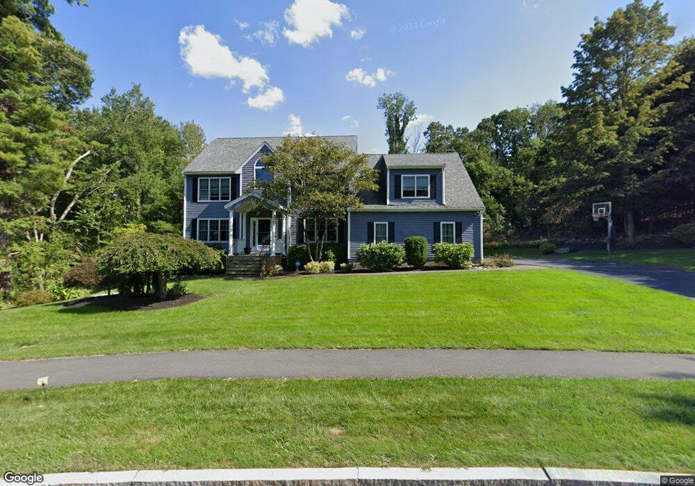
7 Sundance Way Natick, MA 01760
Estimated Value: $1,664,000 - $1,880,000
4
Beds
3
Baths
3,500
Sq Ft
$506/Sq Ft
Est. Value
About This Home
This home is located at 7 Sundance Way, Natick, MA 01760 and is currently estimated at $1,772,258, approximately $506 per square foot. 7 Sundance Way is a home located in Middlesex County with nearby schools including Natick High School, Memorial Elementary School, and J F Kennedy Middle School.
Ownership History
Date
Name
Owned For
Owner Type
Purchase Details
Closed on
Jun 8, 2007
Sold by
Lopes Dawn E and Lopes Joel R
Bought by
Pole Colleen D and Pole Stephen T
Current Estimated Value
Home Financials for this Owner
Home Financials are based on the most recent Mortgage that was taken out on this home.
Original Mortgage
$345,000
Outstanding Balance
$210,875
Interest Rate
6.17%
Mortgage Type
Purchase Money Mortgage
Estimated Equity
$1,561,383
Create a Home Valuation Report for This Property
The Home Valuation Report is an in-depth analysis detailing your home's value as well as a comparison with similar homes in the area
Home Values in the Area
Average Home Value in this Area
Purchase History
| Date | Buyer | Sale Price | Title Company |
|---|---|---|---|
| Pole Colleen D | $801,000 | -- |
Source: Public Records
Mortgage History
| Date | Status | Borrower | Loan Amount |
|---|---|---|---|
| Open | Pole Colleen D | $345,000 |
Source: Public Records
Tax History Compared to Growth
Tax History
| Year | Tax Paid | Tax Assessment Tax Assessment Total Assessment is a certain percentage of the fair market value that is determined by local assessors to be the total taxable value of land and additions on the property. | Land | Improvement |
|---|---|---|---|---|
| 2025 | $18,525 | $1,548,900 | $525,800 | $1,023,100 |
| 2024 | $17,842 | $1,455,300 | $496,600 | $958,700 |
| 2023 | $17,037 | $1,347,900 | $496,800 | $851,100 |
| 2022 | $16,163 | $1,211,600 | $414,000 | $797,600 |
| 2021 | $7,373 | $1,136,000 | $391,300 | $744,700 |
| 2020 | $15,230 | $1,119,000 | $374,300 | $744,700 |
| 2019 | $10,110 | $1,119,000 | $374,300 | $744,700 |
| 2018 | $13,859 | $1,062,000 | $358,100 | $703,900 |
| 2017 | $5,513 | $1,038,900 | $347,500 | $691,400 |
| 2016 | $11,074 | $816,100 | $347,500 | $468,600 |
| 2015 | $10,737 | $776,900 | $347,500 | $429,400 |
Source: Public Records
Map
Nearby Homes
- 10 Sundance Way
- 94 Woodland St
- 39 Davis Brook Dr
- 5 Deer Path
- 11 Avon St
- 15 Penobscot Rd
- 67 E Central St & 5 Union St
- 5 Wilson St Unit 5A
- 6B Lincoln St Unit 6B
- 15 Church St Unit 3
- 4B Lincoln St Unit 4B
- 21 Harvest Moon Dr
- 3 Wilson St Unit 3B
- 8 Floral Ave Unit 8
- 62 E Central St Unit 305
- 48 S Main St Unit 7
- 6 Ambler Ct
- 20 Marion St
- 8 Floral Avenue Extension
- 3 Vale St Unit B
- 14 Clearview Dr
- 9 Sundance Way
- 8 Sundance Way
- 9 Moccasin Path
- 7 Moccasin Path
- 16 Clearview Dr
- 12 Clearview Dr
- 11 Moccasin Path
- 6 Sundance Way
- 10 Clearview Dr
- 11 Sundance Way
- Lot 8 Clearview Dr
- 4 Moccasin Path
- 5 Moccasin Path
- 5 Moccasin Path
- 5 Moccasin Path Unit 5
- 8 Clearview Dr
- 17 Clearview Dr
- 6 Moccasin Path
- 12 Sundance Way