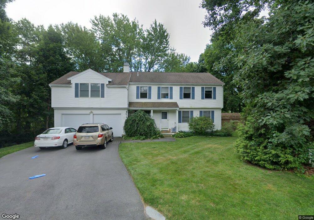
7 Townsend Cir Natick, MA 01760
Estimated Value: $1,143,000 - $1,259,000
5
Beds
3
Baths
2,476
Sq Ft
$479/Sq Ft
Est. Value
About This Home
This home is located at 7 Townsend Cir, Natick, MA 01760 and is currently estimated at $1,184,822, approximately $478 per square foot. 7 Townsend Cir is a home located in Middlesex County with nearby schools including Natick High School, J F Kennedy Middle School, and Johnson Elementary School.
Ownership History
Date
Name
Owned For
Owner Type
Purchase Details
Closed on
Dec 21, 2018
Sold by
Rivard Michael D and Rivard Karin K
Bought by
Rivard Michael D
Current Estimated Value
Home Financials for this Owner
Home Financials are based on the most recent Mortgage that was taken out on this home.
Original Mortgage
$500,000
Outstanding Balance
$440,511
Interest Rate
4.8%
Mortgage Type
Adjustable Rate Mortgage/ARM
Estimated Equity
$744,311
Purchase Details
Closed on
Apr 28, 1995
Sold by
Neuberger Peter and Yeh Lo-Ping
Bought by
Rivard Michael D and Rivard Karin K
Home Financials for this Owner
Home Financials are based on the most recent Mortgage that was taken out on this home.
Original Mortgage
$213,600
Interest Rate
8.33%
Mortgage Type
Purchase Money Mortgage
Purchase Details
Closed on
Jul 22, 1992
Sold by
Ccs Rt
Bought by
Neuberger Peter and Yeh Lo-Ping
Home Financials for this Owner
Home Financials are based on the most recent Mortgage that was taken out on this home.
Original Mortgage
$184,000
Interest Rate
8.49%
Mortgage Type
Purchase Money Mortgage
Create a Home Valuation Report for This Property
The Home Valuation Report is an in-depth analysis detailing your home's value as well as a comparison with similar homes in the area
Home Values in the Area
Average Home Value in this Area
Purchase History
| Date | Buyer | Sale Price | Title Company |
|---|---|---|---|
| Rivard Michael D | -- | -- | |
| Rivard Michael D | $267,000 | -- | |
| Neuberger Peter | $230,000 | -- |
Source: Public Records
Mortgage History
| Date | Status | Borrower | Loan Amount |
|---|---|---|---|
| Open | Rivard Michael D | $500,000 | |
| Previous Owner | Rivard Michael D | $213,000 | |
| Previous Owner | Rivard Michael D | $213,600 | |
| Previous Owner | Neuberger Peter | $184,000 |
Source: Public Records
Tax History
| Year | Tax Paid | Tax Assessment Tax Assessment Total Assessment is a certain percentage of the fair market value that is determined by local assessors to be the total taxable value of land and additions on the property. | Land | Improvement |
|---|---|---|---|---|
| 2025 | $11,632 | $972,600 | $453,100 | $519,500 |
| 2024 | $11,240 | $916,800 | $426,400 | $490,400 |
| 2023 | $10,867 | $859,700 | $407,800 | $451,900 |
| 2022 | $10,628 | $796,700 | $368,500 | $428,200 |
| 2021 | $346 | $746,800 | $347,400 | $399,400 |
| 2020 | $9,949 | $731,000 | $331,600 | $399,400 |
| 2019 | $9,291 | $731,000 | $331,600 | $399,400 |
| 2018 | $331 | $730,100 | $315,800 | $414,300 |
| 2017 | $9,191 | $681,300 | $274,800 | $406,500 |
| 2016 | $8,911 | $656,700 | $253,800 | $402,900 |
| 2015 | $8,555 | $619,000 | $253,800 | $365,200 |
Source: Public Records
Map
Nearby Homes
- 79 Speen St
- 28 Sylvester Rd
- 5 Lanes End
- 1 Fern St
- 46 Silver Hill Ln Unit 1
- 36 Silver Hill Ln Unit 21
- 3 Silver Hill Ln Unit 6
- 26 Wellesley Ave Unit B
- 1 Post Oak Ln Unit 19
- 34 Walden Dr Unit 5
- 30 Walden Dr Unit 7
- 8 Walden Dr Unit 13
- 15 Edwards Rd
- 8 Village Way Unit 11
- 57 Village Brook Ln Unit 5
- 52 Village Brook Ln Unit 14
- 15 Village Way Unit 8
- 16 West St
- 27 Stillman St
- 21 Kelsey Rd
Your Personal Tour Guide
Ask me questions while you tour the home.