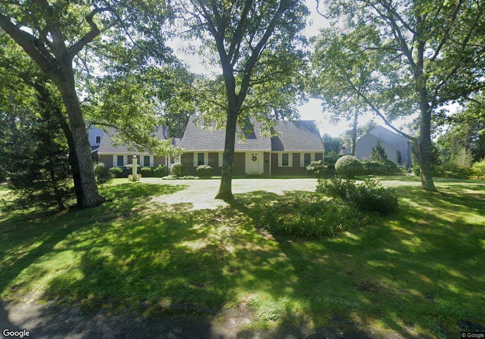
7 Warren Rd Buzzards Bay, MA 02532
Estimated Value: $755,000 - $1,050,000
3
Beds
3
Baths
2,331
Sq Ft
$396/Sq Ft
Est. Value
About This Home
This home is located at 7 Warren Rd, Buzzards Bay, MA 02532 and is currently estimated at $924,174, approximately $396 per square foot. 7 Warren Rd is a home located in Barnstable County with nearby schools including Bourne High School, St Margaret Regional School, and Cadence Academy Preschool - Bourne.
Ownership History
Date
Name
Owned For
Owner Type
Purchase Details
Closed on
Jan 22, 2009
Sold by
Riordan Judith A
Bought by
Judith A Riordan T A and Judith Riordan
Current Estimated Value
Purchase Details
Closed on
Jul 11, 1994
Sold by
Wysocki Mona J
Bought by
Riordan Judith A
Create a Home Valuation Report for This Property
The Home Valuation Report is an in-depth analysis detailing your home's value as well as a comparison with similar homes in the area
Purchase History
| Date | Buyer | Sale Price | Title Company |
|---|---|---|---|
| Judith A Riordan T A | -- | -- | |
| Judith A Riordan T A | -- | -- | |
| Riordan Judith A | $72,500 | -- | |
| Riordan Judith A | $72,500 | -- |
Source: Public Records
Mortgage History
| Date | Status | Borrower | Loan Amount |
|---|---|---|---|
| Previous Owner | Riordan Judith A | $70,000 | |
| Previous Owner | Riordan Judith A | $75,000 |
Source: Public Records
Tax History
| Year | Tax Paid | Tax Assessment Tax Assessment Total Assessment is a certain percentage of the fair market value that is determined by local assessors to be the total taxable value of land and additions on the property. | Land | Improvement |
|---|---|---|---|---|
| 2025 | $6,557 | $839,600 | $350,300 | $489,300 |
| 2024 | $6,411 | $799,400 | $333,600 | $465,800 |
| 2023 | $6,232 | $707,400 | $295,200 | $412,200 |
| 2022 | $5,978 | $592,500 | $261,300 | $331,200 |
| 2021 | $5,849 | $543,100 | $237,800 | $305,300 |
| 2020 | $5,541 | $515,900 | $235,500 | $280,400 |
| 2019 | $5,495 | $522,800 | $255,100 | $267,700 |
| 2018 | $4,822 | $457,500 | $205,600 | $251,900 |
| 2017 | $4,635 | $450,000 | $197,500 | $252,500 |
| 2016 | $4,510 | $443,900 | $197,500 | $246,400 |
| 2015 | $4,470 | $443,900 | $197,500 | $246,400 |
Source: Public Records
Map
Nearby Homes
- 35 Benedict Rd
- 60 Bourne Neck Dr
- 203 County Rd
- 5 Zoli Ln
- 13 Laurel Hill Ct
- 46 Holt Rd Unit B
- 46 Holt Rd
- 40-A Lafayette Ave
- 4 Van Bummel Rd
- 5 Sea Knoll Ct
- 566 Shore Rd
- 12 Turnberry Rd Unit 12
- 3 Fairway Dr Unit F
- 44 Cotuit Rd
- 16 Amberwood Ct
- 36B Starboard Dr Unit 36E
- 36B Starboard Dr Unit 36G
- 36B Starboard Dr Unit 36C
- 36B Starboard Dr Unit 36A
- 36B Starboard Dr Unit 36D
Your Personal Tour Guide
Ask me questions while you tour the home.