


70 4th St Silver City, NV 89428
Estimated payment $1,455/month
Total Views
63,474
1
Bed
1
Bath
803
Sq Ft
$342
Price per Sq Ft
Highlights
- 0.61 Acre Lot
- Covered Deck
- Wood Flooring
- Mountain View
- Vaulted Ceiling
- Main Floor Primary Bedroom
About This Home
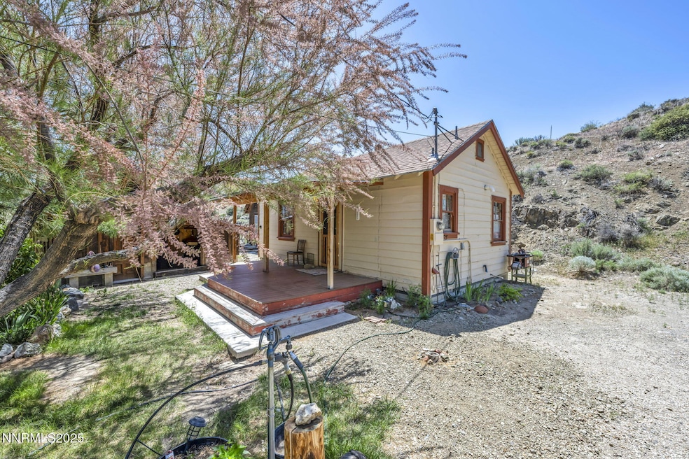
Charming Historic Gem in Silver City! Step back in time with this beautifully updated 1900s home. The property is being sold with 285 Main Street (APN#: 008-01-604). The main structure on the Fourth Street property has a square footage of 419 sq. ft. and the main structure on the Main Street property has a square footage of 384 sq. ft., for a total combined total square footage of 803 sq. ft. The property at 70 Fourth Street has a .61 acre lot, and the property at 285 Main Street consists of a .33 acre lot, for a total combined acreage of .94 acreage. The open-concept layout at 70 Fourth Street features an updated kitchen, full bathroom with shower stall, convenient laundry room, and a versatile loft area perfect for extra sleeping or lounging. The home's interior boasts gorgeous wooden ceilings with exposed high beams, rich wood floors, and abundant natural light that adds warmth and character throughout. Relax on the charming covered deck and take in the peaceful surroundings. The property includes two additional structures — one ideal for storage, and a larger shed that's perfect for a workshop or studio space. With plenty of room to expand or build further, this property offers endless potential. Whether you're seeking a weekend escape, full-time residence, or creative retreat, this Silver City treasure is not to be missed! The adjacent property at 285 Main Street currently does not have a viable working septic system but could be used as an office or an additional storage area. The property at 285 Main Street is being sold with 70 Fourth Street as access to 70 Fourth Street is across the front of the 285 Main Street property and also across the lower corner of APN#: 008-01-706 via an Access and Parking Agreement.
Home Details
Home Type
- Single Family
Est. Annual Taxes
- $462
Year Built
- Built in 1900
Lot Details
- 0.61 Acre Lot
- Landscaped
- Level Lot
- Front Yard Sprinklers
- Manual Sprinklers System
- Property is zoned SF
Property Views
- Mountain
- Desert
- Valley
Home Design
- Pitched Roof
- Composition Roof
- Wood Siding
- Stick Built Home
Interior Spaces
- 803 Sq Ft Home
- 1-Story Property
- Vaulted Ceiling
- Free Standing Fireplace
- Wood Frame Window
- Great Room
- Loft
- Crawl Space
- Fire and Smoke Detector
Kitchen
- Gas Oven
- Gas Range
- Dishwasher
Flooring
- Wood
- Linoleum
Bedrooms and Bathrooms
- 1 Primary Bedroom on Main
- 1 Full Bathroom
Laundry
- Laundry Room
- Dryer
- Washer
- Shelves in Laundry Area
Parking
- 2 Parking Spaces
- Parking Pad
Outdoor Features
- Covered Deck
- Separate Outdoor Workshop
- Shed
- Storage Shed
Schools
- Dayton Elementary And Middle School
- Dayton High School
Utilities
- Refrigerated and Evaporative Cooling System
- Cooling System Mounted To A Wall/Window
- Heating System Powered By Owned Propane
- Wall Furnace
- Tankless Water Heater
- Propane Water Heater
- Septic Tank
- Internet Available
Community Details
- No Home Owners Association
- Silver City Cdp Community
- Silver City 8 05 & 06 Subdivision
Listing and Financial Details
- Assessor Parcel Number 00801503
Map
Create a Home Valuation Report for This Property
The Home Valuation Report is an in-depth analysis detailing your home's value as well as a comparison with similar homes in the area
Home Values in the Area
Average Home Value in this Area
Tax History
| Year | Tax Paid | Tax Assessment Tax Assessment Total Assessment is a certain percentage of the fair market value that is determined by local assessors to be the total taxable value of land and additions on the property. | Land | Improvement |
|---|---|---|---|---|
| 2025 | $235 | $17,972 | $12,250 | $5,723 |
| 2024 | $228 | $17,898 | $12,250 | $5,647 |
| 2023 | $228 | $8,588 | $3,400 | $5,188 |
| 2022 | $196 | $8,255 | $3,400 | $4,855 |
| 2021 | $190 | $8,052 | $3,400 | $4,652 |
| 2020 | $184 | $7,730 | $3,400 | $4,330 |
| 2019 | $178 | $7,501 | $3,400 | $4,101 |
| 2018 | $170 | $7,324 | $3,400 | $3,924 |
| 2017 | $163 | $7,256 | $3,400 | $3,856 |
| 2016 | $159 | $5,450 | $1,700 | $3,750 |
| 2015 | $159 | $4,987 | $1,700 | $3,287 |
| 2014 | $154 | $5,233 | $1,700 | $3,533 |
Source: Public Records
Property History
| Date | Event | Price | List to Sale | Price per Sq Ft |
|---|---|---|---|---|
| 12/29/2025 12/29/25 | For Sale | $275,000 | 0.0% | $342 / Sq Ft |
| 12/27/2025 12/27/25 | Off Market | $275,000 | -- | -- |
| 11/11/2025 11/11/25 | Price Changed | $275,000 | 0.0% | $342 / Sq Ft |
| 11/11/2025 11/11/25 | For Sale | $275,000 | +38.2% | $342 / Sq Ft |
| 06/18/2025 06/18/25 | Off Market | $199,000 | -- | -- |
| 05/27/2025 05/27/25 | For Sale | $199,000 | -- | $248 / Sq Ft |
Source: Northern Nevada Regional MLS
Purchase History
| Date | Type | Sale Price | Title Company |
|---|---|---|---|
| Administrators Deed | -- | None Listed On Document | |
| Warranty Deed | -- | Ticor Title Carson City | |
| Warranty Deed | -- | Ticor Title Carson City | |
| Warranty Deed | -- | Ticor Title Gardnervile | |
| Warranty Deed | -- | Ticor Title Carson City | |
| Warranty Deed | $38,000 | Northern Nevada Title Cc | |
| Warranty Deed | -- | Ticor Title Carson City |
Source: Public Records
About the Listing Agent
Kathy Tatro and Adrienne Jordan Phenix, known as TEAM TATRO, are mother and daughter. Kathy and Adrienne love Nevada! Kathy has lived in Nevada since ’72, and Adrienne is a native Nevadan! This helps TEAM TATRO better serve both sellers and buyers because of their extensive knowledge of Nevada. They love real estate, and it is obvious.
Adrienne graduated from UNR in Business Marketing (2009), she became a Realtor and TEAM TATRO started. She also has her Masters in Education from
Adrienne's Other Listings
Source: Northern Nevada Regional MLS
MLS Number: 250050455
APN: 008-015-03
Disclaimer: Certain information contained herein is derived from information provided by parties other than Homes.com. All information provided is deemed reliable, but is not guaranteed to be accurate and should be independently verified.
![]() IDX information is provided exclusively for personal, non-commercial use, and may not be used for any purpose other than to identify prospective properties consumers may be interested in purchasing. Information is deemed reliable but not guaranteed. The content relating to real estate for sale on this web site comes in part from the Broker Reciprocity/ IDX program of the Northern Nevada Regional Multiple Listing Service°. Real estate listings held by brokerage firms other than Ten-X are marked with the Broker Reciprocity logo and detailed information about those listings includes the name of the listing brokerage. Any use of the content other than by a search performed by a consumer looking to purchase or rent real estate is prohibited. © 2026 Northern Nevada Regional Multiple Listing Service® MLS. All rights reserved.
IDX information is provided exclusively for personal, non-commercial use, and may not be used for any purpose other than to identify prospective properties consumers may be interested in purchasing. Information is deemed reliable but not guaranteed. The content relating to real estate for sale on this web site comes in part from the Broker Reciprocity/ IDX program of the Northern Nevada Regional Multiple Listing Service°. Real estate listings held by brokerage firms other than Ten-X are marked with the Broker Reciprocity logo and detailed information about those listings includes the name of the listing brokerage. Any use of the content other than by a search performed by a consumer looking to purchase or rent real estate is prohibited. © 2026 Northern Nevada Regional Multiple Listing Service® MLS. All rights reserved.
Nearby Homes
- 100 Pedlar Rd
- 55 4th St
- 286 Nevada 341
- 1341 N Main St
- 305a Grosh Ave
- 310 Grosh Ave
- 505 S C St
- 738 Butte Creek Rd
- 140 Rose Peak Rd
- 7 D Grosh Ave
- 395 S D St
- 16 Stope Rd
- 375 S D St
- 202 Rose Peak Rd
- 204 Rose Peak Rd
- 206 Rose Peak Rd
- 208 Rose Peak Rd
- 399 Russell Rd Unit Homesite 115
- 398 Russell Rd Unit Homesite 86
- 63 Jasper Ln
- 603 E College Pkwy
- 700 Hot Springs Rd
- 730 Silver Oak Dr
- 1600 E Long St
- 3418 Imperial Way Unit C
- 3230 Imperial Way
- 2021 Lone Mountain Dr
- 3162 Allen Way
- 616 E John St
- 400 S Saliman Rd Unit B-21
- 1301 Como St
- 103 N Harbin Ave Unit 3
- 832 S Saliman Rd
- 1220 E Fifth St
- 2364 Devin Ave
- 2492 Devin Ave
- 2396 Devin Ave
- 2444 Devin Ave
- 2428 Devin Ave
- 2491 Devin Ave
Your Personal Tour Guide
Ask me questions while you tour the home.