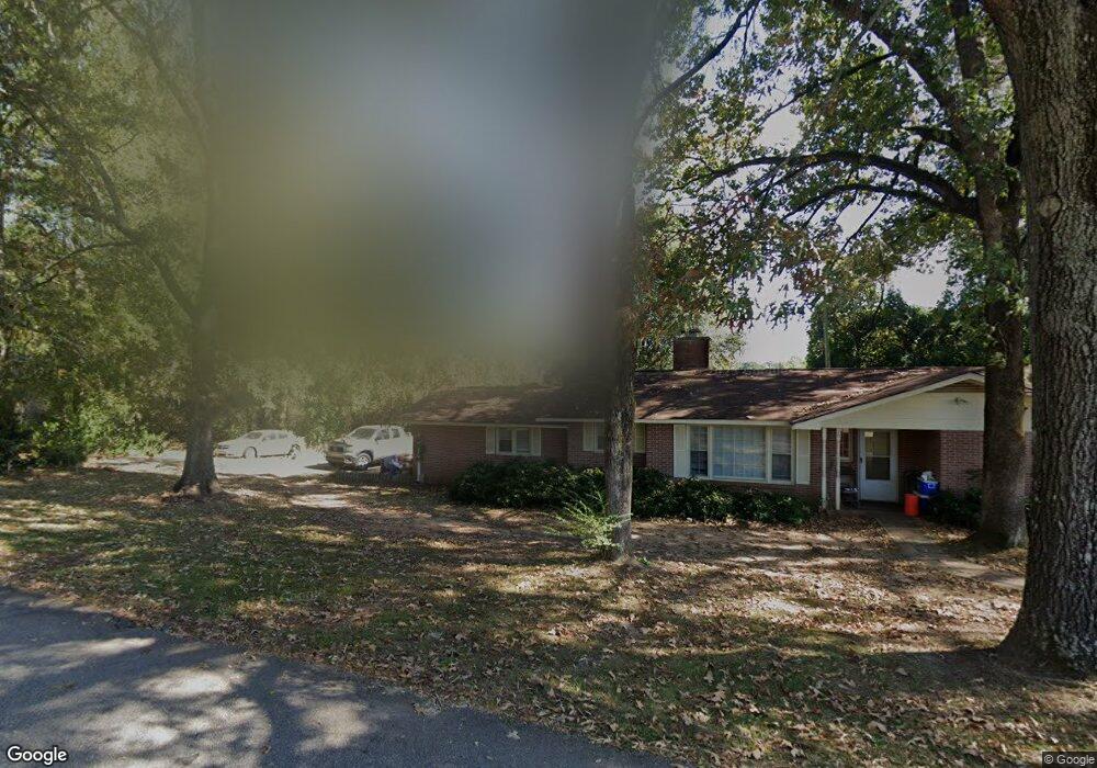
70 Avery Dr Lagrange, GA 30240
Estimated Value: $163,000 - $220,000
3
Beds
2
Baths
1,970
Sq Ft
$96/Sq Ft
Est. Value
About This Home
This home is located at 70 Avery Dr, Lagrange, GA 30240 and is currently estimated at $188,781, approximately $95 per square foot. 70 Avery Dr is a home located in Troup County with nearby schools including Berta Weathersbee Elementary School, Whitesville Road Elementary School, and Long Cane Elementary School.
Ownership History
Date
Name
Owned For
Owner Type
Purchase Details
Closed on
Jun 27, 2024
Sold by
Aspinwall Tiffany
Bought by
Daniel Tiffany S
Current Estimated Value
Purchase Details
Closed on
Jan 6, 2004
Sold by
Ray Ernest and Tamara Lynn
Bought by
Aspinwall Partnership
Purchase Details
Closed on
Apr 1, 1999
Sold by
Murrell Sandra
Bought by
Ray Ernest and Tamara Lynn
Purchase Details
Closed on
Apr 15, 1998
Sold by
Donald Murrell
Bought by
Murrell Sandra
Purchase Details
Closed on
Sep 15, 1978
Bought by
Donald Murrell
Purchase Details
Closed on
Jun 8, 1976
Purchase Details
Closed on
Nov 25, 1975
Purchase Details
Closed on
Jan 1, 1971
Purchase Details
Closed on
Jan 1, 1965
Create a Home Valuation Report for This Property
The Home Valuation Report is an in-depth analysis detailing your home's value as well as a comparison with similar homes in the area
Purchase History
| Date | Buyer | Sale Price | Title Company |
|---|---|---|---|
| Daniel Tiffany S | -- | -- | |
| Aspinwall Partnership | $68,700 | -- | |
| Ray Ernest | $72,900 | -- | |
| Murrell Sandra | -- | -- | |
| Donald Murrell | -- | -- | |
| -- | -- | -- | |
| -- | -- | -- | |
| -- | -- | -- | |
| -- | -- | -- |
Source: Public Records
Tax History
| Year | Tax Paid | Tax Assessment Tax Assessment Total Assessment is a certain percentage of the fair market value that is determined by local assessors to be the total taxable value of land and additions on the property. | Land | Improvement |
|---|---|---|---|---|
| 2025 | $1,717 | $62,940 | $6,040 | $56,900 |
| 2024 | $1,431 | $52,460 | $6,200 | $46,260 |
| 2023 | $1,393 | $51,060 | $6,200 | $44,860 |
| 2022 | $1,338 | $47,940 | $6,200 | $41,740 |
| 2021 | $1,260 | $41,764 | $8,160 | $33,604 |
| 2020 | $1,260 | $41,764 | $8,160 | $33,604 |
| 2019 | $1,203 | $39,888 | $6,560 | $33,328 |
| 2018 | $1,113 | $36,904 | $6,608 | $30,296 |
| 2017 | $1,113 | $36,904 | $6,608 | $30,296 |
| 2016 | $1,083 | $35,910 | $6,608 | $29,302 |
| 2015 | $1,085 | $35,910 | $6,608 | $29,302 |
| 2014 | $1,002 | $33,103 | $6,608 | $26,495 |
| 2013 | -- | $35,341 | $6,608 | $28,733 |
Source: Public Records
Map
Nearby Homes
- 3 Reed Dr
- 0 Unit 10514554
- 0 Bradfield Dr Unit 10568803
- 8 Horace Carter Rd
- 120 Laurel Ridge Ave E
- 101 Crown St Unit LOT 5
- 102 Crown St Unit LOT 1
- 134 Laurel Ridge Ave E
- 149 Laurel Ridge Ave E
- 427 Fling Rd
- 205 Grady St
- 608 Wilburn Ave
- 610 Wilburn Ave
- 107 Clark St
- 223 Pinehaven Dr
- 211 Moores Hill
- 0 Moores Hill
- 509 Connie Dr
- 202 Parker Ln
- 808 S Fling Rd
- 86 Avery Dr
- 75 Avery Dr
- 46 Avery Dr
- 22 Avery Ln
- 2106 West Point Rd
- 41 Morningside Dr
- 107 Avery Dr
- 102 Avery Dr
- 2116 West Point Rd
- LOT 9 Morningside Dr
- 9 Morningside Dr
- 2092 W Point Rd
- 59 Morningside Dr
- 103 Avery Dr
- 40 Morningside Dr
- 50 Morningside Dr
- 2094 W Point Rd
- 11 Sunset Dr
- 11 Sunset Dr Unit 1
- 62 Morningside Dr
Your Personal Tour Guide
Ask me questions while you tour the home.